Science Features
 Loading Page...

The world’s longest-running Earth-observing satellite program — Landsat — turns 40.
The world’s longest-running Earth-observing satellite program — Landsat — is 40 years old.
NASA — working in cooperation with the U.S. Department of the Interior (DOI) and its science agency, the USGS — launched the first Landsat satellite on July 23, 1972. The resulting 40-year archive of Earth observations from the Landsat fleet forms an impartial, comprehensive, and easily accessed register of human and natural changes on the land.
Remote-sensing satellites, such as the Landsat series, help scientists to observe the world beyond the power of human sight, to monitor changes, and to detect critical trends in the conditions of natural resources. Data supplied by Landsat supports the improvement of human and environmental health, energy and water management, urban planning, disaster recovery, and crop monitoring.
Through 40 years of continuous coverage, the Landsat series of Earth observation satellites has become a fundamental global reference for scientific issues related to land use and natural resources. Landsat is valued all over the world as the gold standard of land observation. No other satellite program, in our nation or in any other country, comes close to having the historical length and breadth, the continuity and the coverage, of the Landsat archive.
A Versatile Perspective
Landsat satellites can give us a view as broad as 12,000 square miles per scene while characterizing land cover in units the size of a baseball diamond. In one instant look from over 400 miles in space, a single Landsat scene can record the condition of hundreds of thousands of acres of grassland, agricultural crops, or forests.

A comparison of the images illustrates the significant growth in the greater D.C. area. Major urban development can be seen the surrounding communities of Rockville, Greenbelt, and Suitland, Maryland. The expanded Woodrow Wilson Bridge, connecting Springfield, Virginia, with Oxon Hill, Maryland, is evident. The record of surface change is used by urban planners and local officials to evaluate the rate and direction of growth in the area.
Landsat images from space are not just pictures. They contain many layers of data collected at different points along the visible and invisible light spectrum. Consequently, Landsat images can show where vegetation is thriving and where it is stressed, where droughts are occurring, where wildland fire is a danger, and where erosion has altered coastlines or river courses.
Landsat images reveal subtle, gradual changes, such as Wyoming rangelands greening up after a drought, as well as massive landscape changes that occur in rapidly growing urban areas. Landsat can also provide inexpensive assessments of sudden natural or human-induced disasters, such as the number of acres charred by a forest fire or the extent of tsunami inundation.
Impartial information freely available
The Department of the Interior’s policy of releasing the full Landsat archive at no cost allows everyone to have access to this important resource, allowing researchers in the private sector and at universities to generate even more data applications — applications that serve commercial endeavors in agriculture and forestry, that enable land managers in and out of government to work more efficiently, and that define and tackle critical environmental issues.
Landsat and innovation
Landsat has sparked innovation in Earth systems research and in commercial applications of the data from its inception in the mid-1960s. Since 2008, when Landsat images were made available free of charge, there has been a remarkable burst of innovative science applications of the data.
For example, Landsat data played a central role in an award-winning type of mapping that tracks water use. Using Landsat imagery supplied by USGS in combination with ground-based water data, the Idaho Department of Water Resources and the University of Idaho developed a novel method to create water-use maps that are accurate to the scale of individual fields. Water-use maps help save taxpayer money by increasing the accuracy and effectiveness of public decisions involving water — for instance, in monitoring compliance with legal water rights. In 2009, the Kennedy School of Government at Harvard University cited Idaho’s original design for these maps as an outstanding innovation in American government.

The National Land Cover Database (NLCD 2006) produced by USGS and the federal interagency Multi‑Resolution Land Characteristics Consortium (MRLC) from Landsat imagery is a massive database that describes the surface condition of each 30-meter cell of land in the conterminous U.S. One such cell is approximately the area of a baseball diamond. The range and accuracy of the database enables land managers, urban planners, agricultural experts, and scientists with many different interests (for instance, climate change or invasive species) to identify critical characteristics of the land for a wide variety of investigations.
In the beginning
By the mid-1960s, some civilian geologists, geographers, and agronomists were familiar with imaging potential of classified Earth-observing satellites and had also studied the surprisingly detailed land-surface photos taken by early astronauts using hand-held cameras.
In 1966, with NASA still heavily committed to the Apollo Program in preparation for what would be a 1969 moon landing, the USGS convinced Interior Secretary Stewart Udall to hold a press conference announcing Interior’s new Project EROS, the acronym for Earth Resources Observation Satellites, and, furthermore, that Interior’s first satellite would launch in 1969!
In a statement that echoes true to this day, Udall said, “…the time is now right and urgent to apply space technology towards the solution of many pressing natural resources problems being compounded by population and industrial growth.” This bold announcement succeeded as a catalyst for what eventually became the world’s first civilian land-imaging satellite, developed by NASA and launched on July 23, 1972.
Six years earlier, Udall had said the satellite would be “…just the beginning of a great decade in land and resource analysis for a burgeoning population.” Today we celebrate not one but four great decades in Earth science from space.

USGS created the “Earth as Art” series to provide a unique avenue of insight about the geography of selected Landsat scenes that have an artistic resonance. This image is titled “Malaspina Glacier.” The tongue of the Malaspina Glacier, the largest glacier in Alaska, fills most of this image. The Malaspina lies west of Yakutat Bay and covers 1,500 sq mi (3,880 sq km).
On the horizon
NASA is preparing to launch the next Landsat satellite, the Landsat Data Continuity Mission (LDCM), on February 11, 2013, from Vandenberg Air Force Base in California. LDCM will be the most technologically advanced satellite in the Landsat series. LDCM sensors take advantage of evolutionary advances in detector and sensor technologies to improve performance and increase reliability. Once it successfully achieves orbit, LDCM will join the Landsat 5 and Landsat 7 satellites as Landsat 8 to continue the Landsat data record.
Join the celebration
NASA and USGS held a news conference, July 23, to highlight the accomplishments of the Landsat program at the Newseum in Washington, DC.
NASA Television and the NASA website provided live briefing coverage and will maintain archived video of the event. Visit NASA TV or NASA Goddard Multimedia.
For information about “Landsat at 40” anniversary features:
For details about the Landsat program, including current operations and situational updates, visit USGS Landsat.

Dust storms July 21-22 blinded motorists, grounded flights and knocked out electricity. What’s causing the dust storms?

The majority of the nation is facing dry conditions; in most areas drought conditions are expected to persist or intensify. Read more

A contest to celebrate 40 years of Landsat. Read more

Please comment on the USGS’ draft science strategies! Read more

Timing is everything! Consider helping track changes in spring’s arrival

Need a historical map for your genealogy research? You are in luck. We’ve got what you need! Download and view USGS historical maps from the comfort of your own home.

Flood Safety Awareness Week is March. 12-16. What can you do to prepare?

National Groundwater Awareness Week is Mar. 11-17, 2012. See how USGS science is connecting groundwater and surface water.

Since Japan’s March 11, 2011, Tohoku earthquake and subsequent tsunami, scientists at the USGS have learned much to help better prepare for a large earthquake in the United States.

Five USGS employees honored with Distinguished Service Awards for their service to the nation
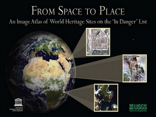
The USGS and UNESCO have produced a book that gives us a new way to look at our shared global heritage.
Groundwater in aquifers on the East Coast and in the Central U.S. has the highest risk of contamination from radium, a naturally occurring radioactive element and known carcinogen.
The proposed USGS budget reflects research priorities to respond to nationally relevant issues, including water quantity and quality, ecosystem restoration, hydraulic fracturing, natural disasters such as floods and earthquakes, and support for the National Ocean Policy, and has a large R&D component.

Caribou expert Layne Adams discusses the lives of reindeer — apart from their famous role on Christmas Eve. How they survive the cold.

Climate science is helping to predict food shortages, identify impacts on human health, and prepare for future conditions.

As demand grows, Landsat data can help us track trends in key resources. Remote-sensing satellites help scientists to observe our world, monitor changes, and detect critical trends in forestry, water, crops, and urban landscapes. Learn more.

A new study provides crucial information for difficult decisions regarding conservation, economic interests, and food and water security. Projected changes for 2010-2099

It's only the beginning of their careers, but these 3 young scientists have forged ahead with innovative research at the frontiers of science. How they've transformed their fields

Oct. 9-15, 2011, is Earth Science Week, themed "Our-Ever Changing Earth," and Oct. 12, 2011, is International Day for Natural Disaster Reduction. Answers to questions posed by a changing world

By 1936, devastating losses of wildlife populations were threatening the Nation’s natural resource heritage. America's first wildlife research center
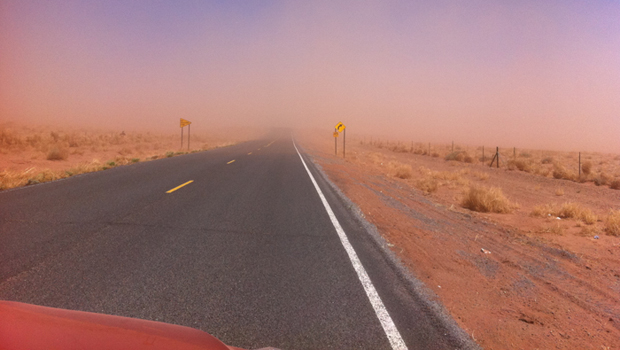
A dust storm on Tuesday, October 4, blinded motorists and caused a large string of motor vehicle crashes, multiple injuries, and at least one death. What’s causing the dust storms?
USGS scientists study walruses off the northwestern Alaska coast in August as part of their ongoing study of how the Pacific walrus are responding to reduced sea ice conditions in late summer and fall.
USGS scientists are collecting water samples and other data to determine trends in ocean acidification from the least explored ocean in the world.
In support of the Famine Early Warning Systems Network, USGS scientists use satellite remote sensing to assess agricultural conditions that foretell famine.
New USGS research shows that rice could become adapted to climate change and some catastrophic events by colonizing its seeds or plants with the spores of tiny naturally occurring fungi. The DNA of the rice plant itself is not changed; instead, researchers are re-creating what normally happens in nature.
Now that field work has wrapped up at the Ice Age "Snowmastodon" fossil site near Snowmass Village, Colo., USGS and other scientists will begin work on unraveling the climate and environmental history of the area.
USGS scientists are studying the Earth’s conditions 3 million years ago to gain insight into the impacts of future climate. Join us Aug. 3 in Reston, Va., to learn how this information is used to better understand the magnitude of changes forecast for the end of this century.
USGS crews continue to measure streamflow and collect water quality and sediment samples in the Ohio and Mississippi River basins using state-of-art instruments.
Over the past four decades, about 14% of the ice and permanent snow of Washington's Mount Rainier has melted due to combined recent warming and reduced precipitation.
USGS science supports management, conservation, and restoration of imperiled, at-risk, and endangered species.
In a unique application of data, this year's report provides the nation's first assessment of birds on public lands and waters.
The USGS, NASA, and other organizations and Federal agencies are studying how climate change affects wildlife and ecosystems.

Using coral growth records and measurements of changing ocean chemistry from increased atmospheric CO2, USGS scientists are providing a foundation for predicting future impacts of ocean acidification and sea-level rise to coral reefs.
Increased dust storm activity may result from enhanced aridity in the Southwest, according to a USGS study.
Provide your input on the draft USGS Global Change Science Strategy by April 8, 2011.
Sea-ice habitats essential to polar bears would likely respond positively should more curbs be placed on global greenhouse gas emissions, according to a new modeling study published today in the journal, Nature.
Landscape photos taken in the same place but many years apart reveal dramatic changes due to human and natural factors. The USGS Desert Laboratory Repeat Photography Collection, the largest archive of its kind in the world, is 50 years old.
Decreasing pH and warming temperatures are changing ocean conditions and affecting coral and algal growth in South Florida. USGS scientists are conducting field measurements to learn more.
Many coastal wetlands worldwide including several on the U.S. Atlantic coast may be more sensitive than previously thought to climate change and sea-level rise in the this century.
USGS findings support recent predictions that climate change will stress ecosystems at lower elevations more than higher elevations. This information may guide future conservation efforts in helping decision makers develop regional landscape predictions about biological responses to climate changes.
The Earth as Art 3 collection, the latest set of Landsat satellite images selected for their artistic quality, reveals an intricate beauty in Earth’s natural patterns.
USGS scientists are investigating sea turtles and their habitats in Dry Tortugas National Park to provide insight that will be used as decision-support tools for managing coral ecosystems.
Looking for information on natural resources, natural hazards, geospatial data, and more? The USGS Education site provides great resources, including lessons, data, maps, and more, to support teaching, learning, K-12 education, and university-level inquiry and research.
The timing of animal migration and reproduction, and observing when plants send out new leaves and bear fruit, is increasingly important in understanding how climate change affects biological and hydrologic systems. Photo credit Copyright C Brandon Cole.
The United States Group on Earth Observations (USGEO) is working to connect Earth observations with public health, agriculture, climate, and data management and dissemination.
USGS studies the relationships among earth surface processes, ecological systems, understanding current changes in the context of prehistoric and recent earth processes, distinguishing between natural and human-influenced changes, and recognizing ecological and physical responses to changes in climate.
The USGS Science Strategy is a comprehensive report to critically examine the USGS's major science goals and priorities for the coming decade. The USGS is moving forward with these strategic science directions in response to the challenges that our Nation's future faces and for the stewards of our Federal lands.

7 p.m.—Public lecture (also live-streamed over the Internet)

USGS-led survey finds that national wildlife refuges rate highly with visitors.

As the climate has warmed, many plants are starting to grow leaves and bloom flowers earlier. A new study published in the journal, Nature, suggests that most field experiments may underestimate the degree to which the timing of leafing and flowering changes with global warming.

Stressed agricultural lands may be releasing less of the moisture needed to protect the breadbasket of a continent.

Spring rains in the eastern Horn of Africa are projected to begin late this year and be substantially lower than normal.

In recognition of World Forestry Day, let’s take a glimpse at USGS science to understand the fate of forests from climate change.

A new study concludes that fossil fuel emissions are likely contributors to a substantial amount of organic carbon found on glaciers in Alaska. Fossil fuel emissions, which contain organic carbon, can speed up the rate of glacier melt when deposited on glacier surfaces. In addition, the organic molecules associated with these deposits can be transportedContinue Reading

The U.S. Geological Survey had a very busy 2011 — below are a few of our highlights from last year.

Despite news articles warning of large-scale releases of methane due to climate change, recent research indicates that most of the world’s gas hydrate deposits should remain stable for the next few thousand years.
Join us on February 1 to view the Earth from space, and discuss the profound impact Landsat has on many facets of our economy, safety, and environment.

Scientists have discovered an outbreak of coral disease called Montipora White Syndrome in Kāneohe Bay, Oahu. The affected coral are of the species Montipora capitata, also known as rice coral.
USGS scientists will join thousands of scientists, managers, and decision makers in Boston this week to present new findings on toxics at the Society for Environmental Toxicology and Chemistry (SETAC) conference in the Hynes Convention Center, Nov. 13-17.

On Nov. 3, USGS scientists Patrick Barnard and William Ellsworth will present a public lecture in Menlo Park, CA, providing Bay Area residents information about USGS research in the San Francisco Bay Area, including recent discoveries beneath San Francisco Bay and ongoing studies to better understand earthquake probabilities and the potential hazards associated with strong ground shaking.

Rivers and streams in the United States are releasing substantially more carbon dioxide into the atmosphere than previously thought.

Climate Change Impacts to Tribal Communities The USGS is working with Native American communities and organizations to understand climate change impacts to their land and neighborhoods. Projects include interviews with indigenous Alaskans to understand their personal observations of climate change, as well as studying how climate change is impacting sand dunes and posing risksContinue Reading

As climate changes, it affects the timing of when leaves emerge, the amount of foliage that grows as well as the timeframe when leaves begin to fall.

How will accelerated glacial melting over the next 50 years as a result of climate change affect the unique Gulf of Alaska and Copper River coastal ecosystems? USGS scientists are studying these processes and impacts.

USGS scientists are assessing the potential to remove CO2 from the atmosphere for storage in other Earth systems through a process called carbon sequestration.

![]() U.S. Department of the Interior |
U.S. Geological Survey
U.S. Department of the Interior |
U.S. Geological Survey
URL: www.usgs.gov/blogs/features/usgs_top_story/landsat-at-40-the-long-view-of-earth-from-space/
Page Contact Information: Ask USGS
Page Last Modified: September 14, 2011


