Science Features
 Loading Page...

USGS vigilant for West Nile virus in wildlife through surveillance, research, and mapping.

Dust storms July 21-22 blinded motorists, grounded flights and knocked out electricity. What’s causing the dust storms?

Please comment on the USGS’ draft science strategies! Read more

While on your spring hike, beware of hitchhiking ticks—they may carry Lyme Disease.

For the first time since its discovery, White-nose syndrome has been found in the West.

The family picnic: food and fun...until unwanted guests show up! Learn what you can do to prevent West Nile virus from infecting your loved ones.

Timing is everything! Consider helping track changes in spring’s arrival

Flood Safety Awareness Week is March. 12-16. What can you do to prepare?

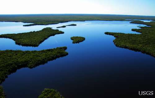
National Groundwater Awareness Week is Mar. 11-17, 2012. See how USGS science is connecting groundwater and surface water.

Since Japan’s March 11, 2011, Tohoku earthquake and subsequent tsunami, scientists at the USGS have learned much to help better prepare for a large earthquake in the United States.

Five USGS employees honored with Distinguished Service Awards for their service to the nation

It’s National Invasive Species Awareness Week. Did you know invasive species cost our country more than 100 billion dollars each year? Get to know America’s ten top invaders this week.

Groundwater in aquifers on the East Coast and in the Central U.S. has the highest risk of contamination from radium, a naturally occurring radioactive element and known carcinogen.
The proposed USGS budget reflects research priorities to respond to nationally relevant issues, including water quantity and quality, ecosystem restoration, hydraulic fracturing, natural disasters such as floods and earthquakes, and support for the National Ocean Policy, and has a large R&D component.

Four new reports examine the contaminants polycyclic aromatic hydrocarbons (PAHs) found in house dust, streams, lakes, soil, and air.

Climate science is helping to predict food shortages, identify impacts on human health, and prepare for future conditions.

It's only the beginning of their careers, but these 3 young scientists have forged ahead with innovative research at the frontiers of science. How they've transformed their fields
Oct. 9-15, 2011, is Earth Science Week, themed "Our-Ever Changing Earth," and Oct. 12, 2011, is International Day for Natural Disaster Reduction. Answers to questions posed by a changing world

By 1936, devastating losses of wildlife populations were threatening the Nation’s natural resource heritage. America's first wildlife research center

A dust storm on Tuesday, October 4, blinded motorists and caused a large string of motor vehicle crashes, multiple injuries, and at least one death. What’s causing the dust storms?
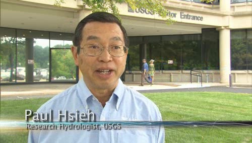
As the team of responders struggled to end the worst oil spill in our Nation’s history, USGS scientist Paul Hsieh provided the critical scientific information needed to make a crucial decision.

The movie Contagion dramatizes the scenario of a global pandemic that begins with the spread of a disease from animals to humans. What are real-life experts doing to prevent a pandemic that originates with wildlife?

On September 11, 2001, as the twin towers of the World Trade Center exploded and collapsed, clouds of dust billowed into the sky and across the city.
Forests play a significant role in removing carbon from the atmosphere by absorbing one-third of carbon emissions annually. This is according to a new U.S. Forest Service study conducted in collaboration with USGS scientists.
USGS crews continue to measure streamflow and collect water quality and sediment samples in the Ohio and Mississippi River basins using state-of-art instruments.
Ten gangly, adolescent whooping cranes have been released in Louisiana, marking a milestone for the USGS, the State of Louisiana, and the whooping cranes. The USGS has the largest breeding flock in the U.S., at about 60 birds. About half of these USGS-raised birds are returned to the wild each year.
Human health, ecological health, and environmental health are closely connected. Join us to learn how USGS science contributes to our understanding of how such environmental factors affect health threats.
Looking for information on natural resources, natural hazards, geospatial data, and more? The USGS Education site provides great resources, including lessons, data, maps, and more, to support teaching, learning, K-12 education, and university-level inquiry and research.
The Chesapeake Bay has long been an R&R destination for DC residents. However, the watershed’s overpopulation contributes to its decline. Join us when USGS’s Scott Phillips and Peter Claggett discuss new science efforts applied to restoring the Nation's largest estuary on October 6th.
USGS scientists help land managers determine if fire is the appropriate strategy for controlling or enhancing specific plant species.
Pharmaceutical manufacturing facilities can be a significant source of pharmaceuticals in surface water. The USGS is working with water utilities to try to reduce the release of pharmaceuticals and other emerging contaminants to the environment.
The United States Group on Earth Observations (USGEO) is working to connect Earth observations with public health, agriculture, climate, and data management and dissemination.
The USGS Science Strategy is a comprehensive report to critically examine the USGS's major science goals and priorities for the coming decade. The USGS is moving forward with these strategic science directions in response to the challenges that our Nation's future faces and for the stewards of our Federal lands.

7 p.m.—Public lecture (also live-streamed over the Internet)

After nearly 2 years of meticulous research, academic and government scientists confirmed that the 2010 oil spill had damaged local coral ecosystems

In recognition of World Forestry Day, let’s take a glimpse at USGS science to understand the fate of forests from climate change.

Join us on March 7 to learn about bat white-nose syndrome, which has killed an estimate 5 million bats, and to discuss the profound impacts this emergent wildlife disease may have in the 21st century.

The U.S. Geological Survey had a very busy 2011 — below are a few of our highlights from last year.

Scientists have discovered an outbreak of coral disease called Montipora White Syndrome in Kāneohe Bay, Oahu. The affected coral are of the species Montipora capitata, also known as rice coral.

Recent USGS research shows that climate, vegetation, groundwater recharge rate, and proximity of the contaminants to the water table can all affect and control natural removal rates.
USGS scientists will join thousands of scientists, managers, and decision makers in Boston this week to present new findings on toxics at the Society for Environmental Toxicology and Chemistry (SETAC) conference in the Hynes Convention Center, Nov. 13-17.

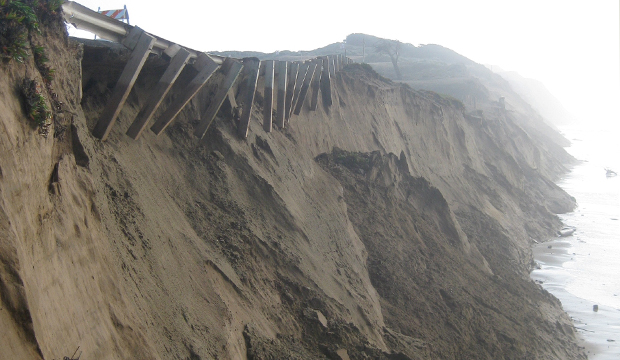
On Nov. 3, USGS scientists Patrick Barnard and William Ellsworth will present a public lecture in Menlo Park, CA, providing Bay Area residents information about USGS research in the San Francisco Bay Area, including recent discoveries beneath San Francisco Bay and ongoing studies to better understand earthquake probabilities and the potential hazards associated with strong ground shaking.

Taking advantage of USGS expertise in satellite telemetry, geospatial mapping and analysis and waterfowl migration monitoring, researchers have tracked waterfowl across Asia, Eastern Europe, and Africa and discovered new flu transmission links.

USGS is working in collaboration with numerous state and federal agencies and tribes to obtain approval for field trials with vaccine-laden, peanut-butter flavored baits and evaluate the safety and effectiveness of the vaccine in grasslands.

Psychedelically colored wolves depicted by thermal imaging will shed light on how mange affects the survival, reproduction and social behavior of wolves in Yellowstone National Park.

![]() U.S. Department of the Interior |
U.S. Geological Survey
U.S. Department of the Interior |
U.S. Geological Survey
URL: www.usgs.gov/blogs/features/science_feature/environmental_health/
Page Contact Information: Ask USGS
Page Last Modified: September 14, 2011


