
Printer-friendly version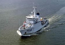

Commerce’s NOAA Ship Thomas Jefferson, one of the most technologically advanced hydrographic survey vessels in the world, will depart its Norfolk, Va. homeport on April 6 to conduct a five-month long effort to map the seafloor and look for hazards to navigation off the Gulf coast. “The Gulf of Mexico has been affected by a number of large hurricanes in recent years, and our work will pinpoint the resulting hazards and shoals in these busy waters,” said Cmdr. Shepard Smith, Thomas Jefferson’s commanding officer. (More)
Comments Closed
Due to increased spam, comments have been closed on this content. If you wish to comment about the content, we encourage you to email webmaster@doc.gov.