Syndicate content

Blog Category: #Irene

Hurricane Irene: NOAA’s Efforts Before, During and After

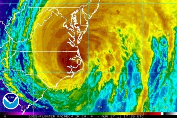
Hurricane Irene as it makes landfall in North Carolina on August 27, 2011

Hurricane season for the National Oceanic and Atmospheric Administration (NOAA) is much more than just naming hurricanes. Even before Irene became the first hurricane of the season, NOAA was tracking her. Things kicked into high gear when Irene formed as a hurricane and appeared headed for landfall.

BEFORE

On Tuesday, August 23rd, NOAA forecasters began tracking and forecasting the track of the recently declared Hurricane Irene as it entered the southeastern Bahamas. As it turned out, this track forecast was remarkably accurate. The 48-hour error for Irene was 20 percent better than the 5-year average, and during the time that watches and warning were in effect for the United States, the average 48-hour track error was half of what it would have been 15 years ago. NOAA has a video of the accuracy of the prediction. The accuracy of this forecast is due to the guidance from the forecast model, advances in satellite-based observations and supercomputers, as well as the regular surveillance missions of the NOAA Gulfstream-IV beginning on August 23rd, allowing NOAA forecasters to watch the development of the storm.

On Friday, August 26th, NOAA and the University of Oklahoma deployed  two state-of-the-art mobile radar instrumented vehicles in North Carolina to intercept Hurricane Irene. These vehicles were equipped with dual-polarization technology that provided more accurate estimates of precipitation type and amount. This was also the first hurricane for the National Science Foundation-funded Rapid X-Scan X-band dual polarized radar which is sensitive enough to detect cloud particles. By using these mobile radar instruments, NOAA was able to compare three different radars scanning for three different features of the storm, giving NOAA scientists valuable data about hurricanes and their rainfall characteristics.

On August 26th and 27th, NOAA provided people in the projected path of the Hurricane with an accurate picture of the impact the Hurricane. In order to battle what NOAA calls “hurricane amnesia,” they released warnings about the dangers of inland flooding so as to advise people not to discount the power of the storm. This is part of NOAA’s broader effort to create a ‘Weather-Ready Nation,’ a strategic plan organized by the National Weather Service to increase the public’s knowledge of different environmental and weather related phenomena.

DURING

Acting Commerce Secretary Blank Statement on Post-Hurricane Status of Commerce Department

Image of Commerce's Herbert Hoover headquarters with Washington Monument behind

In the aftermath of Hurricane Irene, the Department of Commerce (HCHB) facility was inspected and is open for employees to report to work on Monday, August 29, 2011. Federal employees should check with the Department of Commerce website www.commerce.gov or the Office of Personnel Management (OPM) website www.opm.gov to obtain any information about leave and telework policies and any updates. For Commerce employees, the operating status phone lines are 202-482-7400 or 1-877-860-2329 and will be updated accordingly.

Acting Secretary of Commerce Rebecca Blank Urges Hurricane Preparedness

NOAA satellite image of Hurricane Irene (NOAA photo, Aug. 26)

As you know, Hurricane Irene is making its way up the East Coast of the United States. Make no mistake: This is a large and destructive storm and needs to be taken seriously, especially by the millions of people who live, work or travel in Irene’s projected path. 

Time is quickly running out for people to make emergency preparations and move out of harm’s way.

According to our meteorologists at Commerce/NOAA’s National Hurricane Center, Irene will approach the coast of North Carolina tonight, then move north and affect the mid-Atlantic and Northeast. Irene is a large storm and its high winds and heavy rain will affect a large area. Hurricanes like Irene are capable of causing other serious and life-threatening hazards, such as coastal surges, inland flooding and tornadoes. 

We strongly urge all affected Commerce employees and their families to finalize their preparations, so that they can meet their basic needs for a minimum of 72 hours. Visit FEMA’s preparedness sites www.ready.gov or www.listo.gov for tips on how you can make an emergency kit and put an emergency plan in place.

To follow the latest on Hurricane Irene, please visit NOAA’s National Hurricane Center on the Web at www.nhc.noaa.gov/#IRENE and on Twitter at www.twitter.com/NHC_Atlantic. Monitor local media or listen to NOAA Weather Radio for the latest developments and check your local National Weather Service forecast at www.weather.gov.  We also encourage you to consult our Tropical Cyclone Preparedness Guide.

Moreover, please heed the direction of your local officials, and be sure to know your evacuation route in case evacuation orders are given. 

Should you need to seek higher ground or take cover, shelters in North Carolina and other states are being prepared along the East Coast. You can find more information about open Red Cross shelters at www.redcross.org

We’re ready. Please be ready, too.

Commerce and NOAA have been actively mobilizing: Our National Hurricane Center meteorologists have been issuing forecasts, watches and warnings to the media, emergency managers and the public. At the same time, we’re also preparing to respond if necessary to Irene’s aftermath when National Weather Service local forecast offices will issue a variety of severe weather alerts for inland high winds, flooding and severe weather, including tornadoes. 

The larger federal government family is aggressively preparing for two phases of this operation–response and recovery–and has teams and assets moving into all of the states/regions across the East Coast that will be impacted by Hurricane Irene. We are continuing to do everything we can to support the governors and their teams.

On a final note, I want to thank all the NOAA staff who have been working hard this week to ensure that Americans have the most accurate and timely storm updates, watches and warnings—as well as those who will be working through the weekend and coming days to see this storm through and assist in the response phase. Your service to Commerce and the nation is deeply appreciated.