
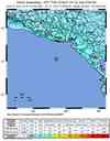
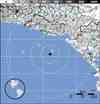
Magnitude 7.3 - OFFSHORE EL SALVADOR
This webpage is being phased out and is no longer maintained. Please use the new Real-time Earthquake Map instead and update your bookmark. See Quick Tips & User Guide.
2012 August 27 04:37:20 UTC
Earthquake Details
- This event has been reviewed by a seismologist.
| Magnitude | 7.3 |
|---|---|
| Date-Time |
|
| Location | 12.278°N, 88.528°W |
| Depth | 20.3 km (12.6 miles) |
| Region | OFFSHORE EL SALVADOR |
| Distances | 111 km (68 miles) S of Puerto El Triunfo, El Salvador 118 km (73 miles) S of Usulutan, El Salvador 123 km (76 miles) S of San Rafael Oriente, El Salvador 133 km (82 miles) S of Santiago de Maria, El Salvador |
| Location Uncertainty | horizontal +/- 16.1 km (10.0 miles); depth +/- 4.2 km (2.6 miles) |
| Parameters | NST=345, Nph=345, Dmin=130.2 km, Rmss=1.21 sec, Gp= 65°, M-type=(unknown type), Version=D |
| Source |
|
| Event ID | usc000c7yw |
- Did you feel it? Report shaking and damage at your location. You can also view a map displaying accumulated data from your report and others.


Earthquake Maps


- Preliminary Earthquake Report
- U.S. Geological Survey, National Earthquake Information Center:
World Data Center for Seismology, Denver
