

Tweets
- Tweets
- Tweets & replies

Want to help @USGS update maps? MT @USGSTNM : Consider The National Map Corps! http://bit.ly/11e0VLu #TNMCorps #mapping #crowdsourcing
New Oregon Maps Feature National Scenic Trails - Sept 15, 2014 - Newly released US Topo maps for Oregon now... http://tmblr.co/ZVm18y1RMfZNh

New HDDS event for fires in California, includes #meadowfire and #KingFire ... RSS for incoming imagery at: http://bit.ly/1r75HL7
New HDDS event this week for #kilauea lava flows. RSS for incoming imagery at: http://bit.ly/1r762gL
NHD News has available the August NHD Newsletter and NHD Photo of the Month: http://nhd.usgs.gov/nhd_news.html

cmc486 & Molly Weasley earn Surveyor’s Chain badge! Welcome to #TNMCorps data volunteers. http://bit.ly/1bcglt2 #USGS #GIS #VGI

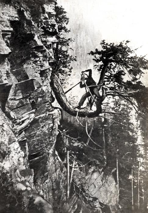
This cartographer went out on a limb (literally) to get the job done. http://on.doi.gov/1p2Lvp0 #TBT pic.twitter.com/C5RdOI08Uf
rfrach, C391 & SSLFCA earn Surveyor’s Chain badge! Welcome to #TNMCorps data volunteers. http://bit.ly/1bcglt2 #USGS #GIS #VGI

Top story: USGS on Twitter: "Boston was founded on this date in 1630. We don't … pic.twitter.com/T7Ha9RFehI, see more http://tweetedtimes.com/search/%23GIS/en?s=tnp …

@USGS - The 3D Elevation Program Initiative—A Call for Action. NEW REPORT. #Geologic Hazards http://pubs.usgs.gov/circ/1399/ pic.twitter.com/40EsZtliP6

Boston was founded on this date in 1630. We don't have a map that old, but here's how it looked on a 1903 @USGS map. pic.twitter.com/Bfj4zRF8JB
Landsat 1 discovered an unknown island in 1976 & the first visitor received a rude welcome from the natives. #NASA http://1.usa.gov/1u1I2xP

RT @USGS_Pubs: Read abt #hydrologic #maps, part of interactive #energy atlas in #USGS report. http://pubs.er.usgs.gov/publication/ofr20141158 … pic.twitter.com/PdzTy6xu7r

RT @mtricomi: New #Oregon US #TopoMaps Feat. National Scenic #Trails #Nationalmaps @USGSTNM http://on.doi.gov/1qbO3R8

Why is 3D Elevation data important? Find out here http://bit.ly/1qUriGl #3DEP pic.twitter.com/4wz4xTLqx7


@USGS pressman places paper on a lithographic stone to print 1of 3 color layers of a topographic map pic.twitter.com/FUcHxSeyp3


New Oregon US Topo Maps Feature National Scenic Trails @USGSTNM http://on.doi.gov/1qbO3R8
#3DEP Program Initiative: Call for Action, released. http://on.doi.gov/1uBdx0G #USGS #GIS #maps #lidar #elevation pic.twitter.com/VeqXmgdSyO

Great for the classroom! Colorful Tapestry of Time & Terrain http://on.doi.gov/X6slqH #backtoschool pic.twitter.com/kBLx59R56C

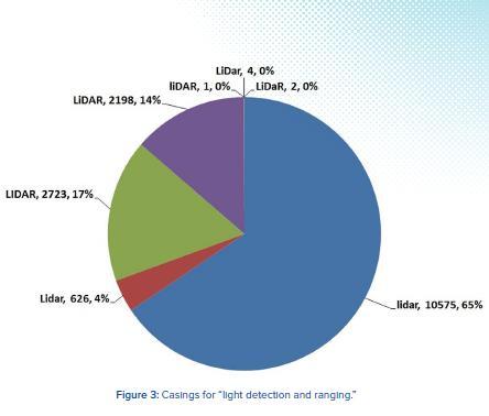
Two #USGS researchers debate: #LiDAR Lidar, LiDAR, LIDAR, LiDar, LiDaR...? Nitpicky? Hardly: http://bit.ly/YLS0qs pic.twitter.com/Kw4pJ3xAvL
Twitter may be over capacity or experiencing a momentary hiccup.
Visit Twitter Status for more information.