
Measuring volcanic gases: emission rates
of sulfur dioxide and carbon dioxide in volcanic plumes

Flying beneath volcanic gas
plume to measure SO2
Photograph
by S.R. Brantley on June 16, 1982
Like this plume rising from the crater of Mount St. Helens, a typical plume of gas rises to some height above a volcano where it reaches equilibrium with the atmosphere and is bent over and blown away. By measuring both the amount of a specific gas in the plume and the wind speed, scientists can calculate the emission rate or discharge of the gas. Several methods are used to measure the amount of specific gases in a volcanic plume.
The amount of sulfur dioxide gas (SO2) in a plume is measured with an optical correlation spectrometer (COSPEC) by moving the instrument beneath the plume in an aircraft or along the ground. The amount of carbon dioxide gas (CO2) in a plume is measured with a small infrared analyzer (LI-COR) by flying the instrument through the plume several times so that it can continuously sample an entire cross section of the plume. A third technique for measuring gases in volcanic plumes involves a Fourier Transform infrared spectrometer system (FTIR) that also continuously samples gas in a volcanic plume.
Coupled with this instrumentation, Global Positioning System (GPS) technology is now routinely used by USGS scientists to map airborne traverses through volcanic plumes. GPS data is simultaneously collected along with chemical data so that accurate plume cross sections and flight paths can later be accurately constructed.
Correlation spectrometer (COSPEC): measuring SO2 emission rate
The correlation spectrometer (COSPEC) has been in use for more than two decades for measuring sulfur dioxide emission rates from various volcanoes throughout the world. Originally designed for measuring industrial pollutants, the COSPEC measures the amount of ultraviolet light absorbed by sulfur dioxide molecules within a volcanic plume. The instrument is calibrated by comparing all measurements to a known SO2 standard mounted in the instrument. Although the COSPEC can be used from the ground in a vehicle or on a tripod to scan a plume, the highest quality measurements are obtained by mounting a COSPEC in an aircraft and flying traverses underneath the plume at right angles to the direction of plume travel.
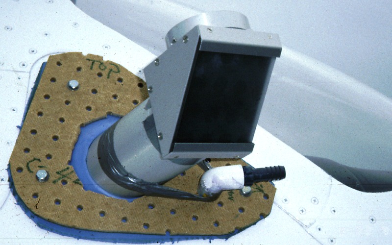
COSPEC from the air: in plane or helicopter

Mounted through
window
Airborne SO2 measurements are made by flying below and at right angles to a volcanic plume with the upward-looking COSPEC. Typically, 3-6 traverses are made beneath the plume in order to determine the average SO2 concentration along a vertical cross section of the plume. Wind speed is determined during flight either by GPS or by comparing true air speed, flying with and against the wind, with true ground speed.
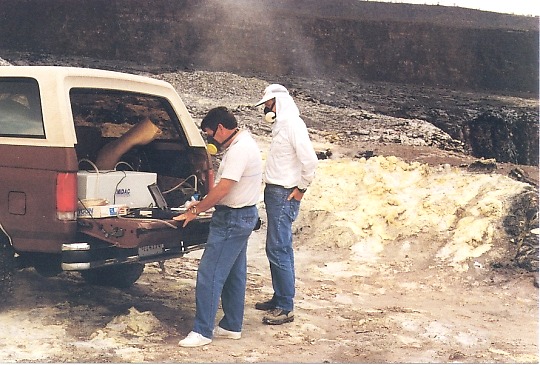
COSPEC from the ground: in a vehicle

View inside vehicle
COSPEC from the ground: from a stationary tripod

On tripod near vent
Examples of COSPEC Data
- Mount St. Helens, 1980-1988
- Kilauea Volcano, 1979-1997: Open-File Report 98-462
- Cook Inlet volcanoes, 1990-1994: Open-File Report 95-55
LI-COR infrared analyzer: measuring CO2 emission rate
Use of a small infrared carbon dioxide analyzer (LI-COR), has recently become a standard method for measuring carbon dioxide emission rates at restless volcanoes. The LI-COR is mounted in a small aircraft configured for sampling outside air. Traverses are then systematically flown through the plume at different elevations until the entire cross-section of the plume is analyzed. From these data, a carbon dioxide emission rate can be calculated. This technique was first employed by USGS scientists at Popocatepetl volcano in Mexico in 1995. More recently, it has been used at several domestic volcanoes.
LI-COR secured inside aircraft

Inside aircraft
Aircraft rigged to sample
gas near COSPEC periscope
Example of LI-COR Data: Mammoth Mountain, Long Valley caldera, California.
Fourier transform infrared spectrometer (FTIR): measuring many volcanic gases
A third technique for measuring gases in volcanic plumes involves the use of a Fourier transform infrared spectrometer system (FTIR). The FTIR is capable of analyzing several gases simultaneously using an open-path or closed-path system. The open-path method uses an optical telescope to aim the FTIR at a target gas some distance away. The infrared light source is either natural solar light or light from a heated filament behind the target gas. The closed-path method involves delivering gas from a plume or fumarole to a gas cell within the FTIR. Recently, a prototype closed-path FTIR successfully measured SO2 at Kilauea Volcano in Hawai`i. The volcano's plume was sampled directly by an FTIR mounted in an aircraft in the same way that the LI-COR anlayzer is used to measure CO2.
FTIR instrument

Interior of FITR
FTIR in vehicle
Kilauea Volcano, Hawai`i
