
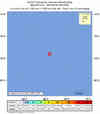
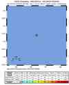
Magnitude 6.7 - MAURITIUS - REUNION REGION
This webpage has been replaced by a new version and will be phased out in the future. Please use our new Real-time Earthquake Map to access the latest earthquake information and event details. The links to the World, US, and CA/NV maps that were in the navigation on the left side of the page have been replaced by the links at the top of the new Map. The Real-time Earthquake Map User Guide describes how to use the map and all its features.
2012 July 26 05:33:31 UTC
Earthquake Details
- This event has been reviewed by a seismologist.
| Magnitude | 6.7 |
|---|---|
| Date-Time |
|
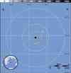
| Location | 17.593°S, 66.363°E |
| Depth | 9.8 km (6.1 miles) |
| Region | MAURITIUS - REUNION REGION |
| Distances | 387 km (240 miles) NE of Port Mathurin, Mauritius 388 km (241 miles) NE of Ile Rodrigues, Northern Mariana Islands 954 km (592 miles) ENE of Bel Air, Mauritius 955 km (593 miles) ENE of Centre de Flacq, Mauritius |
| Location Uncertainty | horizontal +/- 20.3 km (12.6 miles); depth +/- 4.2 km (2.6 miles) |
| Parameters | NST= 62, Nph= 62, Dmin=980.7 km, Rmss=1.56 sec, Gp= 72°, M-type=centroid moment magnitude (Mw), Version=7 |
| Source |
|
| Event ID | usb000bgdg |
- Did you feel it? Report shaking and damage at your location. You can also view a map displaying accumulated data from your report and others.
Earthquake Maps


- Preliminary Earthquake Report
- U.S. Geological Survey, National Earthquake Information Center:
World Data Center for Seismology, Denver
