
Research
Research Projects
 Borehole Geophysics and Rock Mechanics
Using borehole geophysical measurements in conjunction with laboratory studies, scientists study heat flow, stress, fluid pressure, and the mechanical behavior of fault-zone materials at seismogenic depths to yield improved models of the earthquake cycle.
 Earthquake Geology & Paleoseismology
Earthquake geology in the broad sense is the study of the history, effects, and mechanics of earthquakes within and on the Earth's crust.
 Regional & Whole-Earth Structure
Seismic waves from earthquakes, man-made sources both local and distant, computer generated simulations and geophysical surveys are used to determine local, crustal, mantle and core structures of the earth.
 Strong-motion Seismology, Site Response & Ground Motion
Strong motion seismology uses special sensors, called accelerometers, to record large-amplitude ground motions and the response of engineered structures to these motions.
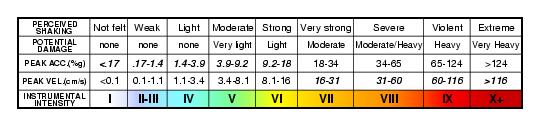
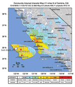 Did You Feel It?
Maps showing the distribution of felt shaking as reported by citizen scientists.
 PAGER - Rapid Assessment of an Earthquake's Impact
Information on the impact of an earthquake using data about the shaking, the affected population, and the affected infrastructure.
 ShakeMap
Maps showing the distribution of shaking produced by an earthquake.
 Earthquake Early Warning
Earthquake Early Warning (EEW) uses existing seismic networks to detect earthquakes rapidly and send a warning ahead of destructive seismic waves.
Data

Searchable databases and downloadable earthquake and seismic data.
Software

Software programs that are available for download.
External Research Support

The U.S. Geological Survey (USGS) invites research proposals that will assist in achieving the goals of the National Earthquake Hazards Reduction Program (NERHP).
