From NASA:
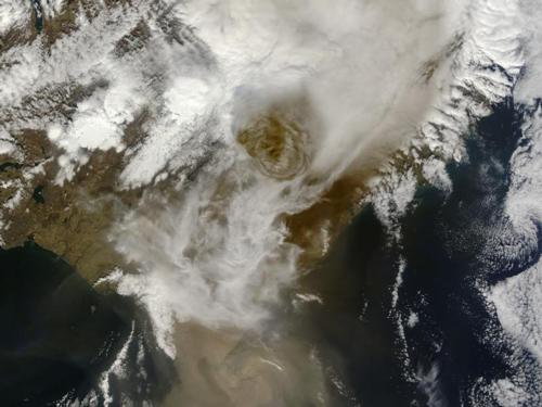
On May 21, 2011, Iceland’s Grimsvotn Volcano erupted, sending an ash plume 12 miles (20 kilometers) high and closing Keflavik Airport, Iceland’s largest. Ash fell on much of Iceland, with some areas pitch black at midday on the 22nd. This eruption is not expected to disrupt air travel as much as that of Eyjafjallajokull in 2010 because the Grimsvotn ash particles are larger and settling out of the atmosphere more quickly.
This natural-color satellite image, acquired by the Moderate Resolution Imaging Spectroradiometer (MODIS) aboard the Terra satellite, shows the towering ash plume at 1:00 p.m. local time. Beneath the ash plume, clouds cover much of the scene. Lingering snow is visible beneath the clouds to the northeast (upper left). Brown ash covers a portion of the Vatnajokull Glacier near the Atlantic coast (lower right).
