
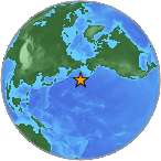
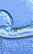
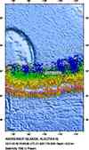
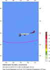
Magnitude 6.4 - ANDREANOF ISLANDS, ALEUTIAN IS., ALASKA
This webpage is being phased out and is no longer maintained. Please use the new Real-time Earthquake Map instead and update your bookmark. See Quick Tips & User Guide.
2012 September 26 23:39:54 UTC
Earthquake Details
- This event has been reviewed by a seismologist.
| Magnitude | 6.4 |
|---|---|
| Date-Time |
|
| Location | 51.634°N, 178.293°W |
| Depth | 9.9 km (6.2 miles) |
| Region | ANDREANOF ISLANDS, ALEUTIAN IS., ALASKA |
| Distances | 34 km (21 miles) S of Tanaga Volcano, Alaska 1487 km (923 miles) SSE of Anadyr', Russia 1580 km (981 miles) E of Petropavlovsk-Kamchatskiy, Russia 1597 km (992 miles) E of Yelizovo, Russia |
| Location Uncertainty | horizontal +/- 13.9 km (8.6 miles); depth +/- 2.6 km (1.6 miles) |
| Parameters | NST=833, Nph=853, Dmin=114.7 km, Rmss=1.17 sec, Gp= 22°, M-type="moment" magnitude from initial P wave (tsuboi method) (Mi/Mwp), Version=E |
| Source |
|
| Event ID | usc000cwni |
- Did you feel it? Report shaking and damage at your location. You can also view a map displaying accumulated data from your report and others.
Earthquake Maps


Scientific & Technical Information

 Tsunami Information
The earthquake locations and magnitudes cited in NOAA tsunami statements and bulletins are preliminary and are superseded by USGS locations and magnitudes computed using more extensive data sets.
General Tsunami Information
Additional Information
- Preliminary Earthquake Report
- U.S. Geological Survey, National Earthquake Information Center:
World Data Center for Seismology, Denver
