
Magnitude 5.1 - HINDU KUSH REGION, AFGHANISTAN
This webpage is being phased out and is no longer maintained. Please use the new Real-time Earthquake Map instead and update your bookmark. See Quick Tips & User Guide.
2012 September 25 08:33:01 UTC
Earthquake Details
- This event has been reviewed by a seismologist.
| Magnitude | 5.1 |
|---|---|
| Date-Time |
|
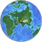
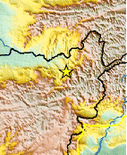
| Location | 36.383°N, 69.186°E |
| Depth | 33.5 km (20.8 miles) |
| Region | HINDU KUSH REGION, AFGHANISTAN |
| Distances | 34 km (21 miles) S of Khanabad, Afghanistan 35 km (21 miles) N of Nahrin, Afghanistan 48 km (29 miles) SE of Kunduz, Afghanistan 50 km (31 miles) SW of Taloqan, Afghanistan |
| Location Uncertainty | horizontal +/- 12.9 km (8.0 miles); depth +/- 7.5 km (4.7 miles) |
| Parameters | NST=163, Nph=166, Dmin=204.8 km, Rmss=0.85 sec, Gp= 47°, M-type=body wave magnitude (Mb), Version=A |
| Source |
|
| Event ID | usc000cvfb |
- Did you feel it? Report shaking and damage at your location. You can also view a map displaying accumulated data from your report and others.
Earthquake Maps


Scientific & Technical Information
 Historic Moment Tensor Solutions
- Preliminary Earthquake Report
- U.S. Geological Survey, National Earthquake Information Center:
World Data Center for Seismology, Denver
