
Volcano Hazards Program Features Archive
-
 New Video Explaining Caldera Formation
To better explain how calderas form, geologist Dina Venezky was filmed demonstrating one of the models made for public outreach events. For more information, please watch the Caldera Demonstration Model.
-
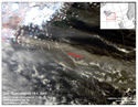 Eyjafjallajökull, Ash, and Eruption Impacts
The recent eruption at Eyjafjallajökull, Iceland has been producing a cloud of steam and volcanic ash that has been affecting air traffic. For more information, please see our Eyjafjallajökull page.
-
 Mount St. Helens 30th Anniversary
On May 18, 1980, Mount St. Helens erupted with a lateral blast followed by a vertical plume of volcanic ash rose over 80,000 feet. Please see the CVO Mount St. Helens Anniversary page for more information.
-
Recovery Funding to Improve Monitoring and Public Safety
The Volcano Hazards Program has received American Recovery and Reinvestment Act funds for six projects that will benefit volcano monitoring at the high-risk volcanic areas our observatories monitor. AVO will receive $7.56 million, CVO will receive $2.4 million, HVO will receive $3.3 million, LVO will receive $200,000, YVO will receive $950,000, and $800,000 was received for upgrading networks in the Commonwealth of the Northern Marianas. For more information, please see the press releases for each observatory: AVO, CVO, HVO, LVO, YVO, and the Northern Mariana Islands.
-
Summary of January - February 2010 Yellowstone Earthquake Swarm
The rate of earthquake occurrence in the Madison Plateau area is now at background levels. The swarm began on January 17, 2010 around 1:00 PM MST about 10 miles (16 km) northwest of the Old Faithful area on the northwestern edge of Yellowstone Caldera. Swarms have occurred in this area several times over the past two decades. YVO continues to monitor the activity. See the Summary of the 2010 Swarm Article for more information.
-
Yellowstone Swarm Continues
The current Yellowstone swarm began January 17, 2010 around 1:00 PM MST about 10 miles (16 km) northwest of the Old Faithful area on the northwestern edge of Yellowstone Caldera. Swarms have occurred in this area several times over the past two decades. See the YVO website for more information.
-
January 2010 is Hawai`i Volcano Awareness Month
Throughout the month of January, the USGS Hawaiian Volcano Observatory (HVO), in cooperation with Hawai'i Volcanoes National Park, Hawai'i County Civil Defense, and the University of Hawai'i at Hilo, will sponsor various events to promote the importance of understanding and respecting the island's volcanoes. Volcano Awareness Month continues throughout the month of January with talks, hikes, and workshops. An event schedule and additional information can be found on the HVO website.
-
Information about Activity at Redoubt Volcano

On June 30 AVO lowered the Aviation Color Code and Volcano Alert Level to Yellow and Advisory at Redoubt volcano based on a significant decrease in the rate of lava extrusion. Between March 22nd and April 4th 2009, Redoubt produced multiple significant explosions that sent ash and gas clouds to as high as 65,000 feet (19.8 km) above sea level and significantly disrupted air traffic. After April 4th, the eruption continued with extrusion of a lava dome within the summit crater, eventually producing a blocky lava flow down the north flank of the volcano. For the most up-to-date information, please see the Redoubt Activity Page.
-
May is Volcano Awareness Month in Washington State

Volcano Awareness Month is an opportunity for Washington State's residents to become familiar with volcano hazards and preparedness. Information about volcanoes in Washington State can be found on the VHP Fact Sheet page and on the Cascades Volcano Observatory (CVO) site. Preparedness information can be found on Washington State's Emergency Management Division (EMD) site.
-
Yellowstone Lake Earthquake Swarm Summary as of 8 January 2009

Seismic activity at Yellowstone Lake in Yellowstone National Park increased in late December 2008. As of January 8, 2009, the seismic activity has markedly decreased. Earthquake swarms within the Yellowstone caldera are typical, with magnitudes occasionally ranging above 4.0. All earthquakes with magnitudes greater than 2.0 have now been reviewed by YVO seismologists. See our new article, Yellowstone Lake Earthquake Swarm Summary as of 8 January 2009 for more information about this swarm and past activity.
-
Third Aleutian Volcano Erupts Explosively

Kasatochi is the third volcano to erupt in the Aleutian Islands in three weeks. Okmok Volcano erupted unexpectedly and explosively on July 12, followed by Cleveland Volcano, 100 miles away, on July 21.
-
Okmok erupts in Alaska

Okmok Volcano in Alaska started erupting on July 12 at 11:43 AKDT (19:43 UTC). The initial phase of the eruption was quite explosive and produced a wet, ash and gas-rich plume that reached 50,000 feet above sea level.
-
Mount St. Helens Eruption Ceases, for now

Scientists say the nearly three and a half years of eruption at Mount St. Helens is over for now and have lowered the Volcano Alert Level from Advisory to Normal and the Aviation Color Code from Yellow to Green.
-
VHP launches Web Site beta

Visit the new Volcanic Activity section of our beta web site. We will be moving pages from the old site and continuing to add new content for the forseeable future.
-
20 Years of AVO

Alaska Volcano Observatory (AVO) Celebrates Twenty Years of Volcano Research and Hazard Mitigation …
-
Halema`uma`u gas plume becomes ash-laden

On the evening of March 23, 2008 small incandescent particles were observed erupting from the vent below the Halema`uma`u Overlook. See the HVO Timeline for more information …
-
Mount St. Helens Alert Level and Aviation Color Code Decreased to Advisory Yellow

Growth of the new lava dome inside the crater of Mount St. Helens, which began in October 2004, appears to have paused …
-
Recent ups and downs of the Yellowstone Caldera

Parts of the Yellowstone Caldera rose as much as 7 cm (~3") per year from 2004 to 2006. …
-
New USGS Hazards Assessment for Medicine Lake Volcano

Medicine Lake volcano covers more than 2000 square km in California. New report covers potential volcano hazards. …
-
New lava flow hazard assessment

Lava flow hazard assessment, as of August 2007, for Kilauea East Rift Zone eruptions, Hawai'i Island …
-
Volcano and Earthquake Mapplets

Track volcanic and earthquake activity on your personal Google Map …
Previous Archive
2008 Jack Kleinman Internship for Volcano Research
08 January 2008
The U.S. Geological Survey, through its Cascades Volcano Observatory in Vancouver, Washington, invites applications for the 2008 Jack Kleinman Volcano Research Grants Program. Stipends of $500 to $2,000 are available to senior undergraduates and graduate students who are conducting research in volcanology, preferably in the Cascade Range, Aleutian volcanic arc, Hawaii, Yellowstone, or Long Valley caldera. The application deadline is March 1, 2008. [Added May 2008] To see this year's winners, please see the Jack Kleinman Internship page.
Recent Scientific Summary of Cascade Volcanoes by Wes Hildreth
17 December 2007

The Cascade magmatic arc is a belt of Quaternary volcanoes that extends 1,250 km from Lassen Peak in northern California to Meager Mountain in Canada, above the subduction zone where the Juan de Fuca Plate plunges beneath the North American Plate. Newly published Professional Paper 1744, Quaternary Magmatism in the Cascades—Geologic Perspectives by Wes Hildreth, presents a synthesis of the entire volcanic arc, addressing all 2,300 known Quaternary volcanoes. Wes Hildreth’s insightful understanding of volcanic processes and his uncompromising scientific integrity make him uniquely qualified to present this synthesis. During more than three decades of volcanological studies, he has carried out comprehensive investigations of Mount Adams, Mount Baker, the Three Sisters, and the Simcoe Mountains Volcanic Field. He also brings a broad experience in other volcanic arcs, having conducted integrated field and laboratory investigations at several major volcanic centers in the Andes and the Aleutian arcs. His expertise and perspective have been further enhanced by in-depth petrologic studies of caldera environments, primarily in Long Valley, California, and Yellowstone. This scientific volume will influence and guide the course of Cascade investigations for decades to come. [excerpted from Foreword]
New Fact Sheet Explains Recent Geysering and other Thermal Instabilities in Hot Creek, CA
2 July 2007
USGS scientists along with our colleagues at the U.S. Forest Service have published a new Fact Sheet, Boiling Water at Hot Creek - The Dangerous and Dynamic Thermal Springs in California's Long Valley Caldera. The Fact Sheet was written in response to safety concerns regarding recent hot spring activity and geysering in Hot Creek Gorge. Due to the unpredictability of the hazardous spring activity, the U.S. Forest Service has closed parts of the Hot Creek Geologic Site. Fact Sheet 2007-3045 explains why the previously popular swimming area is thermally unstable.
Series of Earthquakes in Sierra Nevada near Long Valley Caldera
21 June 2007
For more information please see the summary of the June 12th earthquake sequence south of Long Valley caldera.
New Lava outbreak in Upper East Rift Zone of Kīlauea Volcano
19 June 2007
For more information please see the Kīlauea update page (http://volcanoes.usgs.gov/hvo/activity/kilaueastatus.php). For the most recent images, please see the current images page (http://hvo.wr.usgs.gov/kilauea/update/images.html).
USGS Scientists Publish Design Document for the Database of Worldwide Volcanic Unrest
14 June 2007
The ability to forecast near future activity during periods of volcanic unrest has been a primary concern for human populations living near volcanoes. Our ability to forecast future activity and mitigate hazards is based on knowledge of previous activity at the volcano exhibiting unrest and knowledge of previous activity at similar volcanoes. A small set of experts with past experience are often involved in forecasting. To both preserve the knowledge the experts use and continue to investigate volcanic data to make better forecasts, the World Organization of Volcano Observatories (WOVO) has designed a database called WOVOdat. The Design Document, written by USGS scientists Dina Venezky and Chris Newhall, covers the first phase of the project and explains the schema for version 1.0. For more information, please seeWOVOdat Design Document: The Schema, Table Descriptions, and Create Table Statements for the Database of Worldwide Volcanic Unrest (WOVOdat Version 1.0).
YVO Releases a Preliminary Hazards Assessment of Yellowstone National Park and Vicinity
04 April 2007
Yellowstone Volcano Observatory (YVO) just released a Preliminary Assessment of Volcanic and Hydrothermal Hazards in Yellowstone National Park and Vicinity. The assessment, four years in the making, is authored by Robert Christiansen, a leading expert on the Yellowstone volcanic system, along with eight colleagues. The preliminary assessment has been published as an Open-File Report. Over the next 2 years, the assessment will be enlarged to include a seismic hazards analysis and other additional enhancements. At that point, the hazards assessment will be released as a more formal USGS Scientific Investigations Report that will replace this preliminary report.
2007 Jack Kleinman Internship for Volcano Research
26 January 2007
The U.S. Geological Survey, through its Cascades Volcano Observatory in Vancouver, Washington, invites applications for the 2007 Jack Kleinman Volcano Research Grants Program. Stipends of $500 to $2,000 are available to senior undergraduates and graduate students who are conducting research in volcanology, preferably in the Cascade Range, Aleutian volcanic arc, Hawaii, Yellowstone, or Long Valley caldera. The application deadline is March 1, 2007. For more information please see the Jack Kleinman Internship page.
Farewell to our Colleague and Friend, Jim Luhr
3 January 2007
It is with deep sadness we inform you that our colleague, Jim Luhr, Curator in the Department of Mineral Sciences at the Smithsonian Institution, passed away unexpectedly on January 1, 2007, at the age of 53. He died peacefully in his sleep. He directed the Smithsonian's Global Volcanism Program since 1995, and is well-known for elegantly written descriptions of insightful, multi-pronged studies of his beloved Mexican volcanoes. For more information please see the Smithsonian's page on James Luhr.
This Dynamic Planet Map Third Edition
21 December 2006
The long awaited third edition of the popular This Dynamic Planet map has been released. The map is designed to show Earth's most prominent features when viewed from a distance, and more detailed features upon closer inspection. The back of the map zooms in further, highlighting examples of fundamental processes, while providing text, timelines, references, and other resources to enhance understanding of this dynamic planet. The map was published by the Smithsonian Institution, the U.S. Geological Survey, and the U.S. Naval Research Laboratory. More information about the map can be found on the USGS publications site. For an interactive online version, please see The Smithsonian's This Dynamic Map page.
USGS has Adopted a Common Alert-Level System to Inform Public of Volcanic Activity at U.S. Volcanoes
3 October 2006
The U.S. Geological Survey (USGS) has adopted a common system nationwide for characterizing the level of unrest and eruptive activity at volcanoes. See USGS Volcano-Warning Scheme for the United States for a description of the new alert-level system.
Satellite Technologies Detect Uplift in the Yellowstone Caldera
22 March 2006
This March 2006, the journal Nature published a paper by YVO scientist Charles Wicks and colleagues about a period of uplift in the northern part of the Yellowstone caldera. For more information about the recent findings, please see Satellite Technologies Detect Uplift in the Yellowstone Caldera. See also the InSAR research Group Section.
Volcano Information Statements now Released using the Common Alerting Protocol (CAP)
29 March 2006
The Volcano Hazards Program is now using a standard format called CAP for all volcano information statements. CAP was created to meet the recommendation of the National Science and Technology Council's report on "Effective Disaster Warnings" (2000) that:
"A standard method should be developed to collect and relay instantaneously and automatically all types of hazard warnings and reports locally, regionally and nationally for input into a wide variety of dissemination systems."
The volcano information statements on our websites will look similar to how they have looked in the past. The underlying format, however, is now in eXtensible Markup Language (XML) and includes additional information describing the type of alert for emergency managers. The full CAP messages are available as an RSS feed from the following url http://www.usgs.gov/homepage/rss_feeds.asp#volcanoes. For more information about CAP please see the OASIS website.
U.S. Geological Survey launches new website styles
29 March 2006
The U.S. Geological Survey (USGS) has provided new header and footer templates to give our web pages a unified look and to increase accessibility. The Volcano Hazards Program will slowly roll out the templates starting with new pages. You will notice that changes have been made to this page including easier access to information about erupting volcanoes in the 'Worldwide and U.S. Volcano Updates' and news stories with dates of publication. We will also be adding new features, such as RSS feeds, and revising the navigation. Stay tuned for more information about our exciting web changes.
Five-Year Volcano Hazards Plan Released
The Five-Year Volcano Hazards Plan, Understanding Volcano Hazards and Preventing Volcanic Disasters, A Science Strategy for the Volcano Hazards Program, U.S. Geological Survey, 2004-2008 is now available in pdf format.
