Miriam was a minimal tropical storm that briefly threatened the southern
Baja California peninsula of Mexico before weakening to a tropical
depression.
a. Synoptic History
The antecedent disturbance to Miriam was a weak tropical wave that crossed
the coast of Africa on 29 August. The wave briefly developed some
rotational character in the south-central tropical Atlantic on 2 September,
but then continued to the west without distinction across South
America and emerged into the eastern North Pacific on the 9th.
Westward progression of the wave slowed over the next several days as it
moved into a broad area of low pressure south and southwest of the Gulf of
Tehuantepec, and began to take a more northwesterly track. Dvorak technique
classifications on the disturbance that was to become Miriam began at 0600
UTC on the 15th, although a separate disturbance in the vicinity
had been previously classified for several days. During the day, the system
developed short banding features and by 1800 UTC on the 15th, ship
reports indicated a closed circulation had developed and that a tropical
depression had formed about 250 n mi south-southeast of Cabo San Lucas,
Mexico. The "best track" chart of the tropical cyclone's path is given in
Figure 1,
with the wind and pressure histories shown in
Figure 2 and Figure 3,
respectively. The best track is listed in Table 1.
Over the next 24 hours, the depression moved to the north then
north-northwest with only intermittent organized convection. The system
became a tropical storm at 1200 UTC on the 16th, when it was about
175 n mi southeast of Cabo San Lucas, but weakened within twelve hours to a
depression in southwesterly shear. The depression continued to the
north-northwest into the southern Gulf of California, where the circulation
dissipated shortly after 1200 UTC on the 17th,
when it was about 60 n mi northeast of Cabo San Lucas.
b. Meteorological Statistics
Observations in Miriam (Figure 2
and Figure 3) include satellite-based Dvorak
technique intensity estimates from the Tropical Analysis and Forecast Branch
(TAFB), the Satellite Analysis Branch (SAB) and the U. S. Air Force Weather
Agency (AFWA). Although these estimates support tropical storm strength for
24 hours or longer, scatterometer data from the QuikSCAT satellite suggest
that this interval was no longer than twelve hours, and it is conceivable
that Miriam never truly was a tropical storm.
There were no ship or land-based reports of winds of tropical storm force
associated with Miriam.
c. Casualty and Damage Statistics
There were no reports of damage or casualties associated with Miriam.
d. Forecast and Warning Critique
Miriam was a tropical storm for less than 12 hours, so there are no
verifying forecasts. A tropical storm warning (Table 2)
was issued by the government of Mexico for a portion of the southern Baja
California peninsula, but Miriam weakened to a tropical depression before
reaching the area. The tropical storm warning remained in effect until 1500
UTC on the 17th because Miriam was carried operationally as a
tropical storm until that time.
Table 1.
Best track for Tropical Storm Miriam, 15-17 September 2000.
Date/Time
(UTC) | Position |
Pressure
(mb) |
Wind Speed
(kt) | Stage |
| Lat. (°N) | Lon. (°W) |
| 15 / 1800 | 19.2 | 107.4 | 1005 | 30 | tropical depression |
| 16 / 0000 | 19.8 | 107.4 | 1005 | 30 | " |
| 16 / 0600 | 20.2 | 107.6 | 1005 | 30 | " |
| 16 / 1200 | 20.6 | 107.8 | 1004 | 35 | tropical storm |
| 16 / 1800 | 21.0 | 108.2 | 1004 | 35 | " |
| 17 / 0000 | 21.5 | 108.5 | 1004 | 30 | tropical depression |
| 17 / 0600 | 22.4 | 108.9 | 1005 | 25 | " |
| 17 / 1200 | 23.7 | 109.2 | 1005 | 25 | " |
| 17 / 1800 | | dissipated |
| |
| 16 / 1200 | 20.6 | 107.8 | 1004 | 35 | minimum pressure |
Table 2.
Watch and warning summary for Tropical Storm Miriam, 15-17 September 2000.
Date/Time
(UTC) |
Action |
Location |
| 15 / 2100 | Tropical Storm Warning issued | Baja California peninsula south of 24°N latitude |
| 17 / 1500 | Tropical Storm Warning discontinued | Baja California peninsula south of 24°N latitude |

Figure 1.
Best track positions for Tropical Storm Miriam, 15-17 September 2000.

Figure 2.
Best track maximum sustained surface wind speed curve for Tropical Storm
Miriam, 15-17 September 2000, and the observations on which the best track
curve is based.
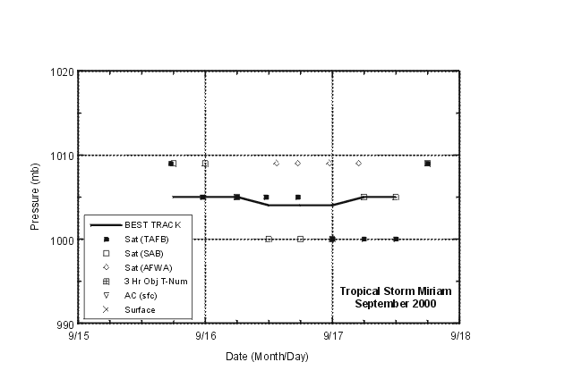
Figure 3.
Best track minimum central pressure curve for Tropical Storm Miriam, 15-17
September 2000, and the observations on which the best track curve is based.
![[NCEP Logo]](graphics/ncep.gif)


