Rosa made landfall near Huatulco, Mexico as a minimal tropical storm.
a. Synoptic History
During the last few days of October, an area of disturbed weather was
located over the southwestern Caribbean Sea. This feature was associated
with a tropical wave that emerged from Africa on 18 October. The system
showed some organization and potential for tropical cyclone development over
the Caribbean. However the opportunity for development in that basin ended
when the disturbed weather moved westward over Central America on 1
November. As the system moved out over the eastern Pacific on the
2nd, it again showed signs of development, with curved cloud
bands and a concentration of deep convection a couple hundred miles
south-southeast of El Salvador. There was no development during the next
day or so as the disturbed weather moved slowly westward. On 3 November
there was a well-defined circulation in the low clouds, and by 1800 UTC deep
convection was close enough to the center to indicate the formation of
Tropical Depression Nineteen-E about 200 n mi south of the El
Salvador/Guatemala border.
With a low- to mid-level ridge to its north, the depression moved westward
over the ensuing couple of days. By 1200 UTC 5 November, the organization
of the system improved slightly and the depression became Tropical Storm
Rosa. The cyclone had turned toward the west-northwest by that time. A
mid-tropospheric trough was located to the northwest of Rosa, along 105-110W
southward to near 15N. This feature eroded the ridge, which induced a
slowing of Rosa's forward speed and a turn toward the north on 6 November.
The storm also reached its peak intensity of 55 kt around 1800 UTC on the
6th. From that point until landfall, Rosa underwent a very slow
weakening. Under the influence of the trough to its northwest, the storm
turned toward the northeast with some increase in forward speed on the
7th. Rosa made landfall early on 8 November, not far from
Huatulco, Mexico with estimated maximum winds of 35 kt, and then quickly
dissipated over mountainous terrain.
b. Meteorological Statistics
Table 1
lists the best track positions and intensities of Rosa at six-hourly
intervals. Figure 1
is a display of this track. Figure 2
and Figure 3 depict the
curves of maximum one-minute average "surface" (10 meters above ground
level) wind speed and minimum central sea-level pressure, respectively, as
functions of time. Also plotted are the observations on which the curves
are based. These consist of measurements by reconnaissance aircraft, and
Dvorak-technique estimates using satellite imagery by the Tropical Analysis
and Forecast Branch (TAFB), the Satellite Analysis Branch (SAB), and the
U.S. Air Force Weather Agency (AFWA). There was one Air Force Hurricane
Hunter aircraft mission into Rosa, while the storm approached the coast on 7
November from about 1500 to 1700 UTC. Interestingly, the Hurricane Hunters
reported a closed eyewall, even though the maximum winds were well below
hurricane strength. A GPS dropsonde deployed in that mission measured a
surface wind of 47 kt at 1658 UTC. The minimum pressure reported from the
aircraft was 1000 mb.
A rainfall total of 103.0 mm associated with Rosa was reported from Puerto
Angel, Mexico.
c. Casualty and Damage Statistics
Rosa was a weakening, minimal tropical storm at landfall, so its impact was
probably not serious. No reports of casualties or damages associated with
Rosa have been received.
d. Forecast and Warning Critique
Rosa was a tropical storm for about 66 h, so there are not many forecasts to
verify. Even for the small number of cases it is interesting to look at the
performance of the numerical guidance as summarized in
Table 2. Track
models such as the GFDL, UKMI, and the consensus numerical forecast, GUNS,
had quite low errors, and these models did very well in capturing the
recurvature of Rosa. The mean official forecast errors were slightly larger
than the most recent ten-year averages.
In general, the intensity of Rosa was over-predicted, by both the official
forecasts and by the SHIPS model. Even though the tropical cyclone was
mostly in a low vertical shear environment, it did not strengthen much
(obviously due to factors other than shear).
Table 3
summarizes the watches and warnings issued for Rosa. The storm made
landfall at the eastern end of the original tropical storm warning area, 22
h after the issuance of this warning.
Table 1.
Best track, Tropical Storm Rosa, 3 - 8 November 2000.
Date/Time
(UTC) | Position |
Pressure
(mb) |
Wind Speed
(kt) | Stage |
| Lat. (°N) | Lon. (°W) |
| 03 / 1800 | 10.3 | 89.8 | 1005 | 25 | tropical depression |
| 04 / 0000 | 10.6 | 90.7 | 1002 | 30 | " |
| 04 / 0600 | 10.7 | 91.8 | 1002 | 30 | " |
| 04 / 1200 | 10.6 | 92.8 | 1003 | 30 | " |
| 04 / 1800 | 10.4 | 94.2 | 1003 | 30 | " |
| 05 / 0000 | 10.4 | 95.2 | 1003 | 30 | " |
| 05 / 0600 | 10.5 | 96.1 | 1003 | 30 | " |
| 05 / 1200 | 10.8 | 97.0 | 1002 | 35 | tropical storm |
| 05 / 1800 | 11.0 | 97.9 | 1001 | 40 | " |
| 06 / 0000 | 11.4 | 98.5 | 997 | 50 | " |
| 06 / 0600 | 11.8 | 98.8 | 994 | 55 | " |
| 06 / 1200 | 12.3 | 98.8 | 994 | 55 | " |
| 06 / 1800 | 12.7 | 98.7 | 993 | 55 | " |
| 07 / 0000 | 13.2 | 98.7 | 995 | 55 | " |
| 07 / 0600 | 13.6 | 98.2 | 997 | 50 | " |
| 07 / 1200 | 14.0 | 97.7 | 998 | 50 | " |
| 07 / 1800 | 14.5 | 97.3 | 1000 | 50 | " |
| 08 / 0000 | 15.0 | 97.0 | 1001 | 45 | " |
| 08 / 0600 | 15.5 | 96.5 | 1002 | 40 | " |
| 08 / 1200 | 16.3 | 95.9 | 1003 | 25 | tropical depression |
| 08 / 1800 | | dissipated |
| |
| 06 / 1800 | 12.7 | 98.7 | 993 | 55 | minimum pressure |
| |
| 08 / 0700 | 15.7 | 96.3 | 1002 | 35 | landfall near Huatulco, Mexico |
Table 2.
Preliminary forecast evaluation of Tropical Storm Rosa Heterogeneous sample
(Errors in nautical miles for tropical storm and hurricane stages with
number of forecasts in parentheses)
| Forecast Technique |
Period (hours) |
| 12 | 24 | 36 | 48 | 72 |
| AVNI | 37 (10) | 88 (8) | 100 (6) | 184 (4) | |
| CLIP | 61 (9) | 136 (7) | 228 (6) | 377 (4) | |
| GFDI | 27 (10) | 38 (8) | 70 (6) | 108 (3) | |
| GUNS | 27 (8) | 31 (7) | 44 (6) | | |
| NGPI | 65 (9) | 79 (8) | 118 (6) | 73 (3) | |
| UKMI | 44 (8) | 55 (7) | 103 (6) | 13 (1) | |
| |
| NHC OFFICIAL | 47 (10) | 88 (8) | 110 (6) | 140 (4) | |
| NHC OFFICIAL 1990-1999 10-year average | 37(2494) | 69(2245) | 101 (1993) | 132 (1760) | 189 (1353) |
Table 3.
Watch and warning summary, Tropical Storm Rosa, November 2000.
Date/Time
(UTC) |
Action |
Location |
| 6/1500 | Hurricane watch issued | Acapulco to Puerto Angel |
| 7/0900 | Tropical storm warning issued | East of Acapulco to Puerto Angel |
| 7/1500 | Hurricane watch and tropical storm warning extended eastward | East of Puerto Angel to Salina Cruz |
| 7/1630 | Tropical storm warning shifted eastward | Punta Maldonaldo eastward to Tonala |
| 7/1630 | Hurricane watch discontinued | Acapulco to Salina Cruz |
| 7/1630 | Tropical storm warning discontinued | West of Punta Maldonaldo |
| 8/0900 | Tropical storm warning discontinued | Punta Maldonaldo eastward to Tonala |

Figure 1.
Best track positions for Tropical Storm Rosa, 3-8 November 2000.

Figure 2.
Best track maximum sustained surface wind speed curve for Tropical Storm
Rosa, 3-8 November 2000, along with selected intensity estimates.
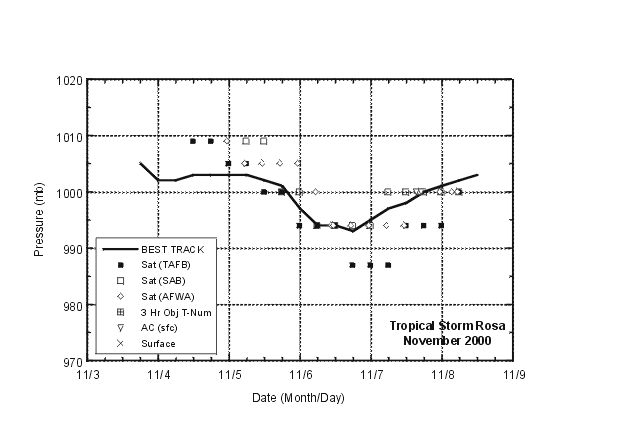
Figure 3.
Best track minimum central pressure curve and central pressure estimates for
Tropical Storm Rosa, 3-8 November 2000.
![[NCEP Logo]](graphics/ncep.gif)


