Aletta was the second-strongest May hurricane on record in the eastern north
Pacific Ocean.
a. Synoptic History
A Hovmöller (longitude vs. time) diagram of satellite images suggests
that Aletta's precursor was a tropical wave that crossed southern Central
America on 18-19 May and produced enhanced cloudiness a few hundred miles to
the south of the Gulf of Tehuantepec on the 20th. There was
sufficient organization of the convective cloud pattern to warrant a Dvorak
classification by 1745 UTC 20 May. Not much further increase in organization
occurred, however, until about 1200 UTC on the 22nd when deep
convection became concentrated near the center of low-cloud rotation. It is
estimated that the season's first tropical depression formed by this time,
centered about 210 n mi south of Acapulco, Mexico. For the next day or so,
additional development was quite slow; by 0600 UTC on the 23rd,
enough of a curved band of cold-topped clouds had formed to classify the
system as Tropical Storm Aletta, centered about 190 n mi south of
Zihuatanejo, Mexico. While strengthening into a tropical storm, Aletta's
direction of motion changed from west-northwestward to westward and its
forward speed decreased from 10-11 kt to 6-7 kt.
High cloud motions and water vapor animations showed a modest amount of
easterly shear over Aletta while it was developing. Slow strengthening
continued on 23 May, but beginning early on the 24th, the shearing seemed to
relax somewhat, and the rate of intensification increased greatly. Aletta
was a hurricane by 1200 UTC on the 24th, and its maximum winds are estimated
to have reached 90 kt by 1800 UTC that day. This was the peak intensity of
the hurricane. By 1200 UTC the following day, easterly shear became more
prominent again, and Aletta began to weaken.
A broad mid-tropospheric trough approaching the Baja California peninsula
eroded the ridge to the north of Aletta, creating a very weak steering
current for the hurricane. For more than two days starting from 0600 UTC on
the 25th, Aletta's center meandered within a 20 n mi radius of 15N 107.5W.
During this time, the combination of easterly, then northeasterly shear, and
the likely upwelling of cooler ocean waters under the quasi-stationary
cyclone promoted continued weakening. Interestingly, by around 0000 UTC on
28 May, the influence of cooled ocean waters may have been the dominant
process. By that time, vertical shear appeared to have become fairly weak
over the area, yet Aletta was dissipating while drifting slowly northward, a
little over 400 n mi south-southeast of Cabo San Lucas. A remnant swirl
of clouds and intermittent showers lingered in that area for several days.
b. Meteorological Statistics
Table 1 lists the best track positions and intensities
of Aletta at six-hourly intervals. Figure 1
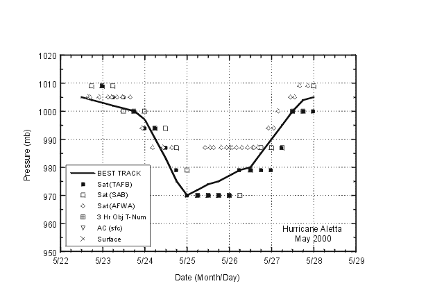
is a display of this track. Figure 2 and
Figure 3 depict the curves of
maximum one-minute average "surface" (10 meters above ground level) wind
speed and minimum central sea-level pressure, respectively, as a function of
time. Also plotted are the observations on which the curves are based.
These consist of Dvorak-technique estimates using satellite imagery from the
Tropical Analysis and Forecast Branch (TAFB), the Satellite Analysis Branch
(SAB), and the U.S. Air Force Weather
Agency (AFWA).
Determining the peak intensity of Aletta was complicated by the satellite
microwave imagery. Special Sensor Microwave Imager (SSM/I) and Tropical
Rainfall Measuring Mission satellite pictures revealed a well-defined,
closed eyewall just before 1800 UTC 24 May, yet Dvorak T-numbers peaked six
to 12 hours after that time, when SSM/I images definitely showed a
less-organized appearance. As a compromise, it is assumed that the
hurricane reached its maximum strength of 90 kt by 1800 UTC on the
24th, somewhat above the Dvorak estimates at that time.
Sea-surface temperature analyses from the U.S. Navy showed a cooling of 1 to
2 degrees C in the area over which Aletta meandered.
c. Casualty and Damage Statistics
Aletta is not known to have caused casualties or damages.
d. Forecast and Warning Critique
It was (correctly) recognized that steering currents were weakening, and
thus the official forecasts never showed Aletta moving very far to the west.
Excluding the tropical depression stage, the mean official forecast errors
for Aletta were 30, 59, 85, 93, and 71 n mi for 12, 24, 36, 48, and 72
hours, respectively. These are lower than the most recent ten-year average
errors. In general, the official forecasts were much better than the track
guidance models except the U.K. Met. Office global model, whose average
track errors were comparable to the official forecasts. Aletta's
strengthening was under-predicted, and it was not forecast to weaken fast
enough by either the official forecast or the Statistical Hurricane
Intensity Prediction Scheme.
Table 1.
Best track, Hurricane Aletta, 22-28 May, 2000.
Date/Time
(UTC) | Position |
Pressure
(mb) |
Wind Speed
(kt) | Stage |
| Lat. (°N) | Lon. (°W) |
| 22 / 1200 | 13.3 | 99.2 | 1005 | 25 | tropical depression |
| 22 / 1800 | 13.9 | 100.2 | 1004 | 30 | " |
| 23 / 0000 | 14.3 | 101.1 | 1003 | 30 | " |
| 23 / 0600 | 14.5 | 101.8 | 1002 | 35 | tropical storm |
| 23 / 1200 | 14.5 | 102.5 | 1001 | 40 | " |
| 23 / 1800 | 14.5 | 103.1 | 1000 | 45 | " |
| 24 / 0000 | 14.6 | 103.7 | 997 | 50 | " |
| 24 / 0600 | 14.6 | 104.3 | 990 | 60 | " |
| 24 / 1200 | 14.7 | 105.1 | 983 | 70 | hurricane |
| 24 / 1800 | 14.8 | 105.9 | 975 | 90 | " |
| 25 / 0000 | 14.9 | 106.6 | 970 | 90 | " |
| 25 / 0600 | 15.0 | 107.3 | 972 | 90 | " |
| 25 / 1200 | 15.1 | 107.7 | 974 | 85 | " |
| 25 / 1800 | 15.0 | 107.7 | 975 | 85 | " |
| 26 / 0000 | 14.8 | 107.7 | 977 | 80 | " |
| 26 / 0600 | 14.8 | 107.6 | 979 | 75 | " |
| 26 / 1200 | 14.8 | 107.5 | 980 | 70 | " |
| 26 / 1800 | 15.0 | 107.8 | 985 | 65 | " |
| 27 / 0000 | 14.8 | 107.8 | 990 | 60 | tropical storm |
| 27 / 0600 | 15.1 | 107.5 | 995 | 55 | " |
| 27 / 1200 | 15.4 | 107.4 | 1000 | 45 | " |
| 27 / 1800 | 15.6 | 107.5 | 1004 | 30 | tropical depression |
| 28 / 0000 | 16.1 | 107.5 | 1005 | 25 | " |
| 28 / 0600 | | dissipated |
| |
| 25 / 0000 | 14.9 | 106.6 | 970 | 90 | minimum pressure |

Figure 1.
Best track positions for Hurricane Aletta, 22-28 May, 2000.
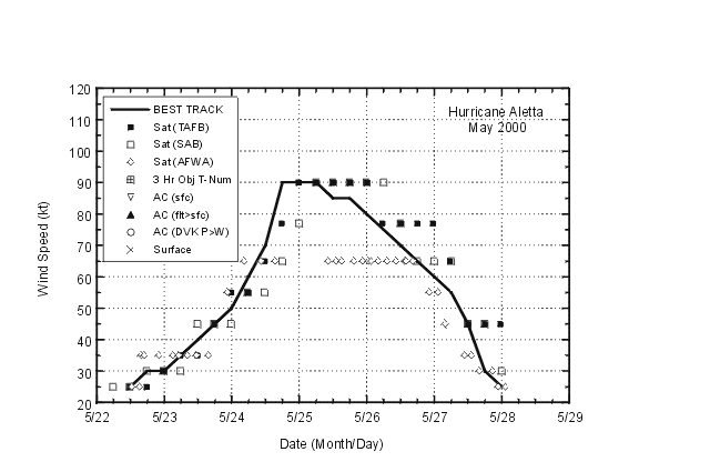
Figure 2.
Best track maximum sustained (one-minute average) wind speed curve for
Hurricane Aletta, May, 2000.

Figure 3.
Best track minimum central pressure curve for Hurricane Aletta, May, 2000.
![[NCEP Logo]](graphics/ncep.gif)