John was a tropical storm for several days and moved from the eastern to the
central Pacific basin. John did not affect land.
a. Synoptic history
John originated as a disturbance in the intertropical convergence zone
(ITCZ). By 25 August, an area of cloudiness in the ITCZ became concentrated
about 1200 n mi southwest of the southern tip of Baja California. A
low-level cloud circulation became apparent from visible satellite imagery
late on the 26th. The twelfth tropical depression of the season in the
eastern Pacific basin formed early on the 28th about 1700 n mi
west-southwest of Baja California, when convection became well organized.
The best track begins at this time and best track positions are plotted in
Figure 1.
Figure 2 and Figure 3
show plots of best-track wind speed and pressure
curves as a function of time, along with the data on which they are based.
Table 1 lists best track position, maximum one-minute
surface wind speed, and minimum central surface pressure at six-hour
intervals.
John strengthened from a depression to an estimated 55-knot tropical storm
in about 18 hours on the 28th, as a small central dense overcast
feature developed. John's motion was slow and northwestward under the
steering of a weak mid-level
ridge to its north on the 28th and 29th and the
intensity remained the same during this time. Early on the 30th,
still moving slowly, John moved across 140W longitude into the central
Pacific basin. John reached its peak intensity of 60 knots on the
30th while its motion became very slow and erratic. It began
moving slowly westward on the 31st and gradually lost convection
and weakened under strong vertical shear and dissipated on 1 September about
750 n mi east-southeast of the Hawaiian Islands.
b. Meteorological statistics
Satellites were the single source of data for determining the best track
given in Table 1
in the eastern Pacific basin. Best-track data west of
140W longitude was provided by the
Central Pacific Hurricane Center
in Honolulu, Hawaii.
c. Casualty and damage statistics
There were no reports of death or damage.
d. Forecast and warning critique
There were six forecasts made in the eastern Pacific basin that verified
while John was a tropical storm and there were only two 72-hour forecasts
verified. The track errors were rather small ranging up to 103 n mi at 72
hours. There was a negative intensity bias during the formative stage and a
slight positive bias thereafter.

Figure 1.
Best track positions for Tropical Storm John, 28 August - 1 September 2000.
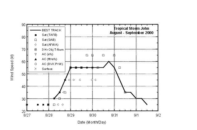
Figure 2.
Best track one-min. wind speed curve, 28 August - 1 September 2000.

Figure 3.
Best track minimum central pressure curve for Tropical Storm John, 28 August
- 1 September 2000.
Table 1.
Best track data for Tropical Storm John, 28 August - 1 September 2000.
Data west of 140W longitude provided by Central Pacific Hurricane Center.
Date/Time
(UTC) | Position |
Pressure
(mb) |
Wind Speed
(kt) | Stage |
| Lat. (°N) | Lon. (°W) |
| 28/0600 | 14.9 | 137.4 | 1007 | 30 | tropical depression |
| 1200 | 15.1 | 137.8 | 1005 | 35 | tropical storm |
| 1800 | 15.4 | 138.2 | 1003 | 45 | " |
| 29/0000 | 15.7 | 138.5 | 1001 | 55 | " |
| 0600 | 16.1 | 138.9 | 1000 | 55 | " |
| 1200 | 16.6 | 139.2 | 999 | 55 | " |
| 1800 | 16.8 | 139.7 | 998 | 55 | " |
| 30/0000 | 16.9 | 140.1 | 997 | 55 | " |
| 0600 | 17.1 | 140.4 | 996 | 55 | " |
| 1200 | 17.2 | 140.5 | 996 | 55 | " |
| 1800 | 17.3 | 140.4 | 994 | 60 | " |
| 31/0000 | 17.4 | 140.3 | 996 | 55 | " |
| 0600 | 17.2 | 140.6 | 999 | 45 | " |
| 1200 | 17.0 | 141.2 | 1004 | 35 | " |
| 1800 | 17.1 | 141.7 | 1006 | 35 | " |
| 01/0000 | 17.3 | 141.9 | 1006 | 30 | tropical depression |
| 0600 | 17.4 | 141.9 | 1008 | 30 | " |
| 1200 | 17.5 | 141.9 | 1008 | 25 | " |
| |
| 30/1800 | 17.3 | 140.4 | 994 | 60 | minimum pressure |
![[NCEP Logo]](graphics/ncep.gif)


