Hurricane Cesar, from the Atlantic basin,
crossed Central America and became Hurricane Douglas in the
eastern North Pacific.
Such a name change for tropical cyclones
crossing from the Atlantic to the eastern North Pacific is based on a
World Meteorological Organization regional agreement.
a. Synoptic History
Hurricane Cesar moved westward over Central
America for about 18 hours and emerged into the Pacific with
tropical storm
strength. It was then designated Tropical Storm Douglas. Once
centered over water, the tropical cyclone intensified rapidly and in about
12 hours reached hurricane
status. Douglas continued moving on a general west and then west-northwest track
around the periphery of a high pressure system over the western United States.
On this track, Douglas reached its estimated maximum intensity of
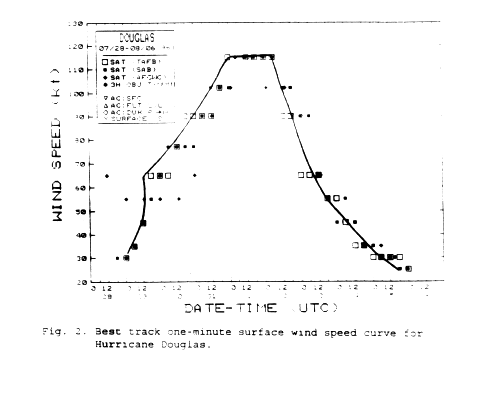
115 knots and minimum pressure of 946 mb at 1200 UTC 1 August
when located about 240 n mi south of the southern tip of Baja
California. Objective T-numbers were oscillating around 6.3 on the
Dvorak scale
during that time. Thereafter, Douglas moved over
cooler waters and a gradual weakening began. It was no longer a
tropical depression
by 0000 UTC 6 August. However, the remnants of Douglas, represented as a swirl
of low clouds, moved westward for several more days.
Douglas's track is shown in Fig. 1 (48K GIF).
Table 1 is a listing, at six-hour intervals, of the
"best-track" position,
estimated minimum central pressure and maximum 1-minute surface wind speed.
b. Meteorological Statistics
The best track pressure and wind curves as a function of time shown in
Figures 2 (14K GIF)
and 3 (16K GIF)
are based on satellite intensity estimates from the
Tropical Analysis and Forecast Branch (TAFB), the
Satellite Analysis Branch (SAB) and the
Air Force Global Weather Central (AFGWC).
Douglas was upgraded to a hurricane based on observations from the vessel Tritonhighway
which reported winds of 69 knots at 1500 UTC 29 July. The vessel was
located just north of the center of the tropical cyclone.
Table 2 contains ships reporting 34-knot
winds or higher associated with Douglas.
c. Casualty and Damage Statistics
The damage associated with this tropical cyclone occurred over
Central America and was attributed to Cesar.
d. Forecast and Warning Critique
Due to the large extent of tropical storm force winds associated
with Douglas and its proximity to the south coast of Mexico,
tropical storm watches and warnings were issued by the government
of Mexico for portions of the coast. These watches and warnings are
listed in Table 3.
The average official track forecast errors for Douglas were 30, 61,
80, 87 and 82 n mi at 12, 24, 36, 48 and 72 hours, respectively.
These errors are much lower than the previous 10-year average
errors at all periods.
Table 3. Watch and warning summary, Hurricane Douglas, July-August 1996.
Date/time
(UTC) | Action | Location |
| 29/0300 | tropical storm watch issued |
South coast of Mexico from Puerto Madero to Acapulco. |
| 29/1500 |
tropical storm watch discontinued |
East of Salina Cruz. |
| tropical storm warning issued |
from Salina Cruz to Acapulco. |
| 30/0300 | tropical storm watch issued |
From just west of Acapulco to Manzanillo. |
| 30/0900 |
tropical storm warning/watch discontinued |
from Salina Cruz to Manzanillo. |
![[NCEP Logo]](graphics/ncep.gif)