

Hydrologic Unit Maps
What are Hydrologic Units?
Adapted from Seaber, P.R., Kapinos, F.P., and Knapp, G.L., 1987, Hydrologic Unit Maps: U.S. Geological Survey Water-Supply Paper 2294, 63 p. Updated information not from this source is enclosed in square brackets below. A copy of USGS Water-Supply Paper 2294 may be ordered from USGS Information Services
The United States is divided and sub-divided into successively smaller hydrologic units which are classified into four levels: regions, sub-regions, accounting units, and cataloging units. The hydrologic units are arranged or nexted within each other, from the smallest (cataloging units) to the largest (regions). Each hydrologic unit is identified by a unique hydrologic unit code (HUC) consisting of two to eight digits based on the four levels of classification in the hydrologic unit system.
 |
| [Figure 1. Map of Water Resources Regions] Click for a larger (13K) image. |
The first level of classification divides the Nation into 21 major geographic areas, or regions. These geographic areas contain either the drainage area of a major river, such as the Missouri region, or the combined drainage areas of a series of rivers, such as the Texas-Gulf region, which includes a number of rivers draining into the Gulf of Mexico. Eighteen of the regions occupy the land area of the conterminous United States. The Alaska is region 19, the Hawaii Islands constitute region 20, and Puerto Rico and other outlying Caribbean areas are region 21. [The regions are shown in figure 1.]
The second level of classification divides the 21 regions into 221 subregions. A subregion includes the area drained by a river system, a reach of a river and its tributaries in that reach, a closed basin(s), or a group of streams forming a coastal drainage area.
The third level of classification subdivides many of the subregions into accounting units. These 378 hydrologic accounting units are nested within, or can be equivalent to the subregions.
The fourth level of classification is the cataloging unit, the smallest element in the hierarchy of hydrologic units. A cataloging unit is a geographic area representing part of all of a surface drainage basin, a combination of drainage basins, or a distinct hydrologic feature. These units subdivide the subregions and accounting units into smaller areas. There are 2264 Cataloging Units in the Nation. Cataloging Units sometimes are called "watersheds.
"The outdated text-formatted list of hydrologic units names and numbers are still available from the 1987 USGS Water-Supply Paper 2294. in either the old original format or in the old tab-delimited format. or old pdf format. The most current and newest list of Hydrologic Units are located and accessible at the bottom of this page under "Newest List of Hydrologic Units Are The Watershed Boundary Dataset (WBD)"
As data gathering practices in remote areas improved over the years, the Alaska 19 region was a remapped in an effort to improve of the HUC's delineation. This renaming and renumbering of the Alaska region 19 are available as a newer_huc_rdb.txt . These Alaskan HUC numbers have changed since publication of WSP 2294. See, for example, the USGS Science in Your Watershed or the EPA Surf Your Watershed site. The most current and newest list of Hydrologic Units are located and accessible at the bottom of this page under "Newest List of Hydrologic Units Are The Watershed Boundary Dataset (WBD)"
Paper Maps
|
A single-sheet hydrologic unit map of the U.S. is available published at a scale of 1:3,500,000 and the map measures 41- by 58-inches. This map is part of The National Atlas of the United States of America series. "Hydrologic Units" is available from USGS at a cost of $7.00 per sheet. Its stock number is TUS5681. The "Hydrologic Units" atlas map supersedes both the "Hydrologic Unit Map of the United States, East" (GHU0057-1T) and the "Hydrologic Unit Map of the United States, West" (GHU0057-2T). Additional information regarding this map is available at: |
Paper maps may be ordered from USGS Information Services
Digital Spatial Data Sets
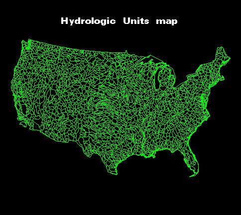 View of huc2m coverage.
The Newest Proper List of the HUC 8-digit, 10-digit, and the 12-digit Codes, Values and Names are in the Watershed Boundary Dataset. |
|
|
1:2,000,000-scale Hydrologic Units (huc2m) 1:250,000-scale Hydrologic Units
(huc250k) The coverage is available on line, at no charge, via links from the file. It may be retrieved as a single file for the lower 48 States. The following is the link to the official Alaska 1:250k HUC coverage:
http://agdc.usgs.gov/data/projects/anwr/metadata/akhuc.html Newest List of Hydrologic Units Are The Watershed Boundary Dataset (WBD)[The newest and most recent HUC delineation efforts have been completed. This dataset named the Watershed Boundary Dataset further divides the huc levels to (5th and 6th levels).see the Watershed Boundary Dataset WBD . The WBD contains the most current 8-digit, 10-digit and 12-digit hucs and are available below. A pdf file which lists the 2-digit, 4-digit, 6-digit and 8-digit hucs for the WBD and their naming convention is available at wbd_huc8.pdf. The Watershed Boundary Dataset (WBD) - is a nationally consistent watershed dataset that is subdivided into 6 levels (12-digit hucs) and is available from the USGS and USDA-NRCS-National Cartographic and Geospatial Center's (NCGC). The new 8-digit WBD (130 megabytes) and the new 12-digit WBD (980 megabytes) are available as geodatabases for download, along with the metadata. The WBD contains the most current, the highest resolution and the most detailed delineation of the watershed boundaries.. |
