NOAA: Heat wave leads to fourth warmest July on record for the U.S.
August 8, 2011
Persistent, scorching heat in the central and eastern regions of the United States shattered long-standing daily and monthly temperature records last month, making it the fourth warmest July on record nationally, according to scientists at NOAA’s National Climatic Data Center. The heat exacerbated drought conditions, resulting in the largest “exceptional” drought footprint in the 12-year history of the U.S. Drought Monitor. “Exceptional” is the most severe category of drought on the drought monitor scale. Drought conditions at several locations in the South region are not as long lived, but are as dry, or drier, than the historic droughts of the 1930s and 1950s.
The average U.S. temperature in July was 77.0 degrees F, which is 2.7 degrees F above the long-term (1901-2000) average. Precipitation, averaged across the nation, was 2.46 inches. This was 0.32 inch below the long-term average, with large variability between regions. This monthly analysis, based on records dating back to 1895, is part of the suite of climate services NOAA provides.
U.S. climate highlights – July-
Oklahoma and Texas had their warmest months ever on record, with average temperatures of 88.9 degrees F and 87.1 degrees F, respectively. Oklahoma's statewide average temperature was the warmest monthly statewide average temperature on record for any state during any month.
-
41 of the lower 48 states had above-normal, much-above-normal, or a record warmest July. Only seven of the lower 48 states – all west of the Rockies – experienced a July average temperature near or below the 20th century average.
-
The South climate region -- Arkansas, Kansas, Louisiana, Mississippi, Oklahoma, and Texas -- had its warmest single calendar month for any climate region on record. The average temperature of 86.1 degrees F, bested the previous all-time record of 85.9 set in July 1980 in the South climate region.
-
Dallas exceeded 100 degrees F on 30 of the 31 days in July. In Oklahoma City, July was the warmest single calendar month, with an average temperature of 89.2, beating the previous record of 88.7 degrees F set in August 1936. Washington, D.C.’s Reagan National Airport had its warmest single calendar month on record, with an average temperature of 84.5 degrees F, breaking the previous record of 83.1 degrees F set in July 2010 and July 1993.
-
The July heat wave was characterized by unusually warm minimum temperatures, during nights and early mornings. This is typical of U.S. heat waves in the last decade, and consistent with increasing warm summer nighttime extremes observed across much of the country since the late 20th century.
-
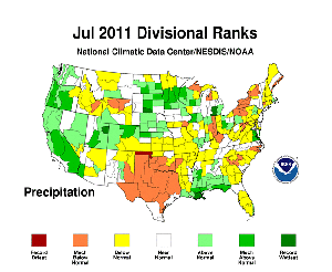
Wetter-than-normal conditions occurred along parts of the Gulf Coast, all of the Pacific Coast, and much of the upper Midwest. California tied for its fifth wettest July. Other states that were abnormally wet in July included: Utah (6th wettest), Wyoming (9th), and South Dakota (10th). At the same time, July offered no relief to the parched soils of Texas and Oklahoma where it was the second (tied) and ninth driest July on record, respectively.
-
Exceptional drought, as defined by the U.S. Drought Monitor, covers more than 75 percent of Texas (201,436 sq mi). Drought conditions are so harsh in some locations that it would take as much as 20 inches of precipitation in one month to end the drought. In Oklahoma, 100 percent of the state is suffering from moderate-exceptional drought compared to the beginning of the water year (9/28/2010), when drought conditions covered only four percent of the state.
-
During the May-July period, a persistent trough/ridge weather pattern set up across the U.S., bringing above normal temperatures to the eastern half of the country and below normal temperatures to the western third. This pattern resulted in Washington State having its coolest May-July period on record, and the Northwest climate region tied with its second coolest. The West climate region had its 10th coolest May-July period.
-
Oklahoma had its warmest May-July period, while 18 other states had a top 10 warmest three months. The South climate region had its second warmest May-July and the Northeast and Southeast both had a top 10 warmest such period.
-
During the same period, a steady flow of moisture from the West coast to the upper Midwest resulted in the fifth wettest May-July for the Northern High Plains area. Meanwhile, it was the second and seventh driest such period for the South and Southeast, respectively.
-
The six-month (February-July) and the year-to-date (January-July) periods were record dry for Texas, New Mexico and the South climate region. Conversely, across the Northern half of the country, most states experienced much above normal precipitation. Three states had record precipitation amounts for the February-July period: Kentucky, Ohio, and Michigan.
- Flooding along the Missouri River Basin is associated with a record amount of precipitation during August 2010-July 2011 in Montana, North Dakota, and Minnesota. The previous records for statewide precipitation during this period were from 1901 and 1907 in North Dakota and Montana, respectively.
NCDC’s monthly reports are based on preliminary data, which are subject to revision. Additional quality control is applied to the data when late reports are received several weeks after the end of the month and as new scientific methods improve NCDC’s processing algorithms.
NOAA’s mission is to understand and predict changes in the Earth's environment, from the depths of the ocean to the surface of the sun, and to conserve and manage our coastal and marine resources. Join us on Facebook, Twitter and our other social media channels.


