Syndicate content

Blog Category: National Weather Service

In Time for Home Opener, NOAA’s National Weather Service Declares Coors Field StormReady®

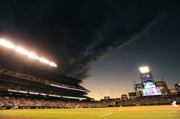
Ominous Clouds Approaching Coors Field (credit: Rich Clarkson and Assoc)

Just in time for their home opener of the 2012 season, fans of Colorado Rockies baseball can feel safer when severe thunderstorms threaten Coors Field now that the park has earned designation as a National Weather Service StormReady® Supporter. Coors Field is the fourth major league baseball park to earn StormReady distinction.

To become StormReady, Rockies officials worked with local emergency management and NOAA’s National Weather Service to adopt a rigorous set of detection and warning criteria to provide protection from severe weather. Warning coordination meteorologist Robert Glancy will present a StormReady plaque and certificates to the Rockies at the April 13 game against the Arizona Diamondbacks.

The nationwide community preparedness program uses a grassroots approach to help communities and organizations develop plans to handle local severe weather and flooding threats. The program is voluntary and provides clear-cut advice from a partnership between local National Weather Service forecast offices, state and local emergency managers and individual organizations. StormReady started in 1999 with seven communities in the Tulsa, Okla. area. There are now nearly 1,900 StormReady sites across the country. StormReady baseball fields include the Minnesota Twins' Target Field, the Cincinnati Reds’ Great American Ballpark, and the St. Louis Cardinals' Busch Stadium.

The National Weather Service in the 1940s

Women hovering over weather maps

Ed. Note: This post is part of a series following the release of the 1940 Census highlighting various Commerce agencies and their hard work on behalf of the American people during the 1940s through today

The 1940s was a pivotal decade for the National Weather Service and the entire field of meteorology. Advancements in technology during the ‘40s, spurred by World War II, provided the scientific foundation for modern day weather forecasting throughout the world.

The agency, founded by Ulysses S. Grant in 1870 and called the Weather Bureau, was originally housed in the War Department. It was later moved to the Department of Agriculture in 1890, and then in 1940 President Roosevelt transferred it to the Department of Commerce. In 1970 the agency was renamed the National Weather Service when it became part of the newly-created National Oceanic and Atmospheric Administration (NOAA) within the Department of Commerce.

In the 1940s, most of the modern technology forecasters rely on today had not yet been invented, such as satellites and super computers. Weather observations were painstakingly logged by hand.

By 1940, the Weather Bureau operated 35 radiosonde stations (weather balloons), allowing for the routine measurement of atmospheric pressure, temperature, humidity, wind direction and speed. In 1942, the Weather Bureau received 25 surplus radars from the military, launching the network of weather surveillance radars.

NOAA Issues Severe Weather Outlook Three Days Ahead of Tragic Tornado Outbreak

NOAA Infographic of Severe Storm and Tornado Watches and Warnings, March 2, 2012

Each year, the United States experiences approximately 1,300 tornadoes. No state is invulnerable to the twisting, destructive winds that emanate from dark thunderstorms–and last week, Nature’s fury was focused on the central and southern states. 

Commerce's National Oceanic and Atmospheric Administration (NOAA) has in place a multifaceted tornado early warning system that includes general area outlooks days in advance and that gives individual cities and towns an average of 14 minutes warning before the potentially deadly tornadoes strike. Through a tremendous investment in research, observing systems and forecasting technology, NOAA’s National Weather Service issues more than 1,000 watches and nearly 30,000 warnings for severe storms and tornadoes each year. 

On February 29, 2012 that investment resulted in an outlook issued by NOAA’s Storm Prediction Center a full three days ahead of the deadly outbreak. This outlook advised forecasters and the emergency management community that conditions would become favorable for severe thunderstorms and tornadoes. 

Advances in research and technology have increased the average warning lead time from only five minutes in the early 1990s to 14 minutes in 2010, thereby giving people and communities more time to seek shelter and reducing loss of life. But technology can only do so much; individuals also need to be prepared for disaster. Visit www.ready.gov to learn more. NOAA Weather Radio webpage  The Weather Channel, "Tornado Outbreak: As It Happened"

Weather By the Numbers: 2011 Remembered as "Year of Severe Weather"

Satellite image of Hurricane Irene

2011 will be remembered as the year of extreme weather. From extreme drought, heat waves and floods to unprecedented tornado outbreaks, hurricanes, wildfires and winter storms, a record 12 weather and climate disasters in 2011 each caused $1 billion or more in damages—and most regrettably, loss of human lives and property. NOAA's National Weather Service has redoubled its efforts to create a "Weather-Ready Nation," where vulnerable communities are better prepared for extreme weather and other natural disasters.  Video of Hurricane Irene approaching the U.S.  |  Severe Weather blog
 
Here are some fast facts for weather by the numbers in 2011:

  • 3 million-plus: the number of residents who lost power during an unseasonably early nor’easter storm that spanned West Virginia to Maine (Oct 29-31)
  • -31 degrees F: the record low temperature reported in Nowata, Oklahoma, on February 10, 2011, which is the coldest temperature on record for the state!
  • 343: the largest outbreak of tornadoes ever recorded (April 25-28), which left a deadly path of destruction from Alabama to Virginia.
  • 199: the number of confirmed tornadoes across the Southeast on April 27, the most on record for any single day in the United States!
  • 1 million-plus: the number of acres burned across just Texas, during a record wildfire season for the Southern Plains states.
  • 3 billion: the potential cost (dollars) to rebuild Joplin, Mo., after it endured the single costliest tornado in U.S. history on May 22. It was the 7th deadliest tornado the U.S. has seen, with 158 lives lost.
  • -7.97: the value of the Palmer Hydrological Drought Index (PHDI) for Texas in September that indicated the most intense drought to affect the state in 117 year period of record.
  • 300 percent: three times the amount of average precipitation (mainly rainfall) in the Ohio Valley that caused historic flooding along the Mississippi river.
  • 19: the number of tropical storms in the Atlantic this year, the 3rd busiest season since record keeping began in 1851

A Year of Extreme Weather

Aerial view of Burlington, North Dakota inundated with flood waters from the Souris River on June 25, 2011

Guest blog post by Assistant Administrator for Weather Services and Director of the National Weather Service Dr. Jack Hayes

As the extreme weather year of 2011 comes to a close, I want to reflect back on this year’s events and look ahead at ways to reduce the devastating impacts of weather on our society.

Crippling snowstorms in the Northeast and Midwest, violent tornadoes in the South, massive river flooding in the Central U.S., Hurricane Irene in the mid-Atlantic, and the epic drought in the Southern Plains accompanied by heat waves and devastating wildfires in some areas have all combined to make this a record-breaking year.

This is the first year since NOAA began keeping records that 12 separate weather events each caused more than $1 billion in damage.   The real story is not the number of events, but the severity of the impacts. Total economic losses from these 12 events have reached nearly $52 billion, and there have been more than 1000 weather-related death this year.

Could some of these deaths have been prevented; could the economic losses be reduced?   I think so and that is why we have launched a new initiative to build a Weather-Ready Nation.  This effort is designed to improve America’s responsiveness to weather events with the ultimate goal of saving more lives and livelihoods.

NOAA and Partners Urge Beach-Goers to 'Break the Grip of the Rip'

Break the Grip of the Rip brochure imageWith summer vacation on the horizon, Commerce's National Oceanic and Atmospheric Administration (NOAA), the United States Lifesaving Association, and the National Park Service are alerting beach-goers to the threat of rip currents and how to prevent drowning from their strong and potentially fatal grip.

Rip currents are the leading near-shore surf hazard, claiming more than 100 lives per year nationally. For that reason, the three organizations are teaming up to sponsor the Rip Current Awareness Campaign from June 6 through 12, with the theme Break the Grip of the Rip®.

NOAA’s National Weather Service forecast offices issue surf zone forecasts, which include rip current information during the summer beach season between Memorial Day and Labor Day. It is important to remember though that rip currents can occur anywhere there is surf.

“Every year, more than 75 million visitors come to swim, fish, snorkel, scuba dive, boat and enjoy the wildlife and majestic scenery in our coastal national parks,” said Jon Jarvis, director of the National Park Service. “To enhance our ability to provide visitors with the latest information on water safety, we are pleased to team up with NOAA and the United States Lifeguarding Association to educate our visitors about water safety.”

Read More
Awareness Week
: June 6-12, 2010

NOAA Expects Busy Atlantic Hurricane Season

Satellite photo of Hurricane Ike, 2008An "active to extremely active" hurricane season is expected for the Atlantic Basin this year according to the seasonal outlook issued today by NOAA’s Climate Prediction Center – a division of the National Weather Service. As with every hurricane season, this outlook underscores the importance of having a hurricane preparedness plan in place.

Across the entire Atlantic Basin for the six-month season, which begins June 1, NOAA is projecting a 70 percent probability of the following ranges:


  • 14 to 23 Named Storms (top winds of 39 mph or higher), including:
  • 8 to 14 Hurricanes (top winds of 74 mph or higher), of which:
  • 3 to 7 could be Major Hurricanes (Category 3, 4 or 5; winds of at least 111 mph)

"If this outlook holds true, this season could be one of the more active on record," said Jane Lubchenco, Ph.D., under secretary of commerce for oceans and atmosphere and NOAA administrator. “The greater likelihood of storms brings an increased risk of a landfall. In short, we urge everyone to be prepared.”

Full NOAA release
Hurricane Preparedness Week site