Vermillion Cliffs--Grand Staircase-Escalante National Monument
BLM
U.S. DEPARTMENT OF THE INTERIOR
BUREAU OF LAND MANAGEMENT
Calf Creek Falls Cedar Mesa Ruin Cleveland Lloyd Gallery Simpson Springs Pony Express Station Cedar Mesa
Utah
BLM>Utah>Vernal
Print Page
Vernal Field Office

In The Spotlight

BLM Approves Uinta Basin Gas Project 

Link to Record of DecisionIn support of President Obama’s all-of-the-above energy strategy to expand safe and responsible domestic energy production, the Bureau of Land Management today approved a natural gas project in Utah’s Uinta Basin that would drill up to approximately 1,300 new wells over 15 years.

The approved plan, which includes a number of measures to minimize impacts on sensitive areas, such as reduced surface disturbance, directional drilling, and extensive environmental protections, will support nearly 200 jobs and guide development of an area that could yield nearly three trillion cubic feet of gas over the next several decades. The Record of Decision (ROD) for the Gasco Uinta Basin Gas Development Environmental Impact Statement (EIS), signed today, will boost America’s energy production and strengthen local economies while responsibly protecting the key landscapes and recreational resources of the project area.

No drilling or infrastructure will be developed in or near Desolation Canyon. The nearest proposed drill site is about four miles northwest of the Desolation Canyon National Historic Landmark and five miles north of the Desolation Canyon Wilderness Study Area. 

News Release  
Gasco EIS Documents and ROD 


Other Environmental Documents

Vernal NEPA Documents
VFO Releases ROD and Approved Resource Management Plan


Green River District, Vernal Field Office
170 South 500 East --  Vernal, UT  84078
Phone: (435) 781-4400  Fax: (435) 781-4410


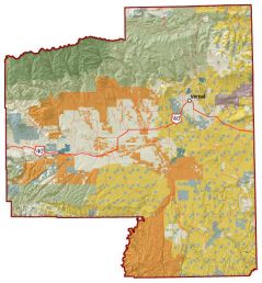
Vernal Field Office Map
Larger Map


 Quick Links


The Vernal Field Office is located in the northeast corner of Utah and administers lands within Daggett, Duchesne and Uintah Counties, plus a small portion of Grand County. The Vernal Field Office also has Native American Trust responsibilities for Northern Ute Tribal and allotted mineral trust lands located within these counties. The area includes the south slope of the Uinta Mountains, the Uinta Basin, and the Book Cliffs region.

The management area in northeastern Utah includes the Uinta Basin, the east and west Tavaputs Plateaus, the Eastern Uinta Mountains (northern boundary), the Book Cliffs (southern boundary), Diamond Mountain, Nine Mile Canyon, and Browns Park. The area is bounded on the west by the Wasatch Mountains and on the east by the Douglas Creek Arch in Colorado.

There are approximately 5,518,859 acres within the boundary of the Vernal Field Office, of which 1,725,500 acres are BLM managed surface lands. The Vernal Field Office administers energy related mineral activities on 3.8 million acres of Federal mineral lands (includes 1.3 million acres of National Forest Service lands) and post lease mineral operations on Indian trust mineral lands. The 1,911,000 acres of BLM managed mineral estate includes the split estate mineral lands within the Hill Creek Extension (comprises 185,500 acres of mineral estate underlying Indian trust surface).

The Vernal Field Office was designated as a Pilot Office under the Energy Policy Act of 2005. The managed lands contain oil and gas along with other unique mineral resources such as Gilsonite, oil shale, and tar sands.