| | |
In The SpotlightIndian Creek Revised Draft Environmental Assessment out for 30 Day Public Review and CommentA copy of the EA is available at the Monticello Field Office
326 North Main, Monticello, Utah Comments on the EA may be mailed to: BLM_UT_MT_Comments@blm.gov or mailed to: Bureau of Land Management Monticello Field Office Attn: Maxine Deeter P.O. Box 7 Monticello, Utah 84535 *Comment Period Ends October 5, 2012*
Fire restrictions were lifted September 7, 2012
Portion of Chocolate Drop Road Added to Monticello Travel PlanThe Travel Management Plan (TMP) in the 2008 Monticello Bureau of Land Management Field Office Area Resource Management Plan (RMP), allowed for modifications to route designations in the Field Area. (See appendix O.13 of the RMP). A route not originally designated in the TMP has been analyzed and a determination made to add it to the TMP. The route is located on map 13 of the 11' x 17' map set and on D2 of the 24' x 36' map set. A map indicating the exact location of the Chocolate Drop Road is linked below. Location Map
Monticello ROD/RMP
|
|
|
New Special Recreation Permit MoratoriumThere is currently a moratorium on accepting/processing most new Special Recreation Permits (SRP) at the Monticello Field Office. The following are exceptions to the moratorium: - Private use permits on Cedar Mesa will continue to be issued.
- Applications for one-time-use permits on Cedar Mesa and in Dark Canyon for organized, non-commercial groups will be considered. Limiting criteria will be applied in determining if such prospective applications proceed to issuance of a permit.
All Requirements for obtaining Special Recreation Permits in the Monticello Field Office apply. The duration of this moratorium is not established. Updates will be posted at this webpage. We regret the inconvenience this may cause prospective permit holders.
Firewood Permit Information | At this time, all wood permits must be bought in person at the Monticello Field Office. *No online or mail permits are being accepted
| Stipulations l Cedar Mesa Map l Alkali Map |
|
|
|
MCloyd Canyon/Moonhouse Recreation
Management Zone Day Use PermitsPublic access will be limited to 20 people per day via a permit system for day visits. Entry into Moonhouse Recreation Management Zone requires a Special Recreation Permit available only at the Kane Gulch Ranger Station during the high use season between 8:00 a.m. and noon. Day, Week, and Annual Permit holders must get their permits validated for Moonhouse hikes at the Kane Gulch Ranger Station prior to their hike. During the off season, permits will be available on a first come first serve basis at the trailhead entry. All commercial and private groups of 8 or more must have an advance reservation, available from the Monticello Field Office permit desk. Maximum group size is 12. There is no overnight camping within the Management Zone, and car camping is limited only to the designated primitive camp and park area south of Snow Flat Road. Pets are not allowed in this management zone. For more information on Moonhouse and Permits click here.
|
| |
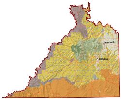
Larger Map
Recreation Permit & General Info | *River 435-587-1544
*Land Based 435-587-1510
*Recreation permits can only be issued through the above numbers (8am-noon only) |
|
The Monticello Field Office is located in the southeast corner of Utah and is part of the Colorado Plateau region. Dominating the landscape near Monticello are the Abajo Mountains, BLM land surrounds this huge monolith.
South of the Abajos is the Comb Ridge Monocline, a major crustal uplift about 80 miles in length. Nearby this major uplift is Grand Gulch, which cuts a serpentine swath through Cedar Mesa.
The Anasazi Indians left a legacy that includes hundreds of cliff dwellings and thousands of pictographs and petroglyphs. Muley Point Overlook sits on a high rim of Cedar Mesa and offers panoramic sweep across Monument Valley and the San Juan River country far below.
Monticello Field Office
365 North Main Street
Monticello, Utah 84535
(435) 587-1500