Photograph of Colorado Mountain Range
BLM
U.S. DEPARTMENT OF THE INTERIOR
BUREAU OF LAND MANAGEMENT
Mesa Autumn Wild Horses oil_rig_OG Boaters Photograph of Ruin
Colorado
BLM>Colorado>Field Offices>Kremmling
Print Page
Kremmling Field Office

In The Spotlight:

  • Competitive Oil and Gas Lease Sale Information
  • Reclamation Plan Template


      ·         Wolford Summer Travel System Active

o   News Release

o   Travel Map

o   Wolford Mountain Area Webpage

o   Target Shooting Information 


·         National Greater Sage-Grouse Planning Strategy

o   Webpage with information including maps and contact information

o   Greater Sage-Grouse Map


·        The Kremmling Draft Resource Management Plan and Draft Environmental Impact Statement are available


·        Special Recreation Permits


·        Volunteer and Job Opportunities

Comments need to be received by October 14, 2012.


Click Here for Maps and Much More!
Maps and Information

Kremmling Weather Link

Walden Weather Link


Rafting


OHV/4x4


Fishing


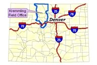
The Kremmling Field Office..

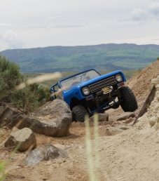
..manages 377,860 acres of land within a boundary four times the size of the State of Rhode Island!  This piece of the BLM extends east to the Continental Divide, west to Steamboat Springs and Vail, south to Interstate-70, and north to the Wyoming border.  The landscape is varied between high mountain peaks and open sage-brush parks.  Our visitors regularly enjoy our vast array of recreation opportunities including rafting, hunting, and off-road use.  Click the map and photos on this page to find out more about the Kremmling Field Office!


Dave Stout,  Field Manager

kfo_webmail@blm.gov

  |  2103 E. Park Avenue    |  P.O. Box 68  |  Kremmling, CO 80459 
(970) 724-3000  |  FAX:(970) 724-3066