A seagull flies over the California Coastal National Monument which stretches along the entire coast of California and extends 12 miles into the Pacific Ocean.  The Monument includes 20,000 rocks, islands, pinnacles and reefs.
BLM
U.S. DEPARTMENT OF THE INTERIOR
BUREAU OF LAND MANAGEMENT
Fort Ord Public Lands Mountain Bike Event San Benito Mountain Conifer detail Prescribed Fire and a Valley Oak Blunt Nosed Leopard Lizard detail California Poppies
California
BLM>California>Hollister
Print Page
Hollister Field Office

Hollister Field Office

The Bureau of Land Management Hollister Field Office administers approximately 284,000 acres of public land in Central California.  Bounded by the Pacific Ocean to the west and the San Joaquin Valley to the east, elevations range from sea level to over 5,000 feet and major landforms include the Diablo Mountain Range, Salinas Valley, and San Joaquin Valley.  Within the lands managed by the Hollister Field Office are three Areas of Critical Environmental Concern, two Research Natural Areas, two National Monuments, a National Historic Trail, and a National Recreation Trail.

Coast live oaks dot a ridgeline over Salinas Valley.  Photo by Bob Wick

Coast Live Oaks dot a ridgeline over the Salinas Valley, Fort Ord National Monument


In the Spotlight
Fort Ord National Monument

Wildflowers on Fort Ord National Monument, photo by B. Wick BLM

On Friday, April 20, 2012, President Obama signed a Proclamation to designate federal lands within the former Fort Ord as a National Monument.

The Fort Ord National Monument holds some of the last undeveloped natural wildlands on the Monterey Peninsula.  The area plays a vital part in the protection of rare species of plants and animals.  World class non-motorized recreational opportunities are available as well.  People can visit three trail access points and the Juan Bautista de Anza National Historic Trail.  Eighty-six miles of trails are open every day from dawn to dusk. Visitors can walk or ride the trails over grassland hills, oak woodlands and coastal chaparral.

Download the new Fort Ord National Monument Trail Map & Brochure!


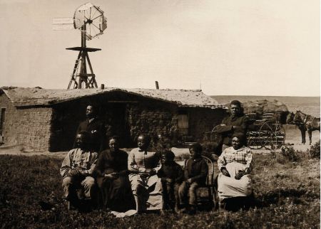
Celebrating the 150th Anniversary of the Homestead Act of 1862

Image of homesteaders in Nebraska, image courtesy Nebraska Historical Society

The Homestead Act of 1862 signed by President Abraham Lincoln helped create the modern West.  Learn more about the Act and its impact on our Nation.


BLM California: Connect 

Facebook linkTwitter linkFlickr linkYouTube linkRSS link


What's Happening Now

Share the Experience: Official Federal Recreation Lands 2012 Photo Contest

FIRE RESTRICTIONS IN EFFECT FOR THE SAN JOAQUIN MANAGEMENT AREA

Wildfires!!  Check INCIWEB for the latest information


Frequently Requested
Clear Creek, photo by BLMClear Creek
Fort Ord Public Lands LogoFort Ord
Hunting iconHunting
Map graphic, image by BLMMaps
BLM National System of Public Lands logoNEPA
Panoche Creek, photo by BLMPanoche Hills
Picnic site, photo by BLMRecreation
Tumey Hills, photo by BLMTumey Hills
Hollister Field Office sign, photo by BLMWeb Directory

A Sound Investment

The BLM: A Sound Investment for America

Public Land in California

Public Land Statistics (BLM Annual Reports)


Rick Cooper, Field Manager
Bureau of Land Management
Hollister Field Office
20 Hamilton Court
Hollister, CA 95023
Phone: (831) 630-5000
Fax: (831) 630-5055
Office Hours: 7:30 a.m. - 4:00 p.m., M-F
Contact us by Email