Beryl was a weak tropical storm that moved over the southwest Gulf of Mexico
and across the northeast coast of Mexico, and eventually dissipated inland
over the mountains of northern Mexico.
a. Synoptic history
Tropical Storm Beryl originated from a tropical wave that emerged from the
coast of Africa with a closed circulation on 3 August. The wave tracked
westward across the tropical North Atlantic and fractured into two separate
entities - the northern portion of wave, which became major Hurricane
Alberto, tracked northwestward, and the southern portion that tracked
westward and eventually became Beryl. The southern portion of the wave
produced little or no deep convection as it tracked across the Atlantic and
into the Caribbean Sea. Not until the wave reached the Yucatan Peninsula of
Mexico on 12 August did deep convection redevelop, mainly due to local
diurnal heating. However, convergence of the afternoon coastal seabreeze
fronts may have helped to concentrate the low-level vorticity of the wave
and produce a closed circulation over the western Yucatan Peninsula. The
wave emerged over the southern Gulf of Mexico and Bay of Campeche early on
the 13th as a broad area of low pressure with a large closed
circulation. Later that day, the wave was upgraded to Tropical Depression
Five based on satellite intensity estimates and an Air Force Reserve
reconnaissance aircraft observation of a broad closed circulation and surface
winds of 30 kt.
Tropical Depression Five tracked northwestward across the southwest Gulf of
Mexico and reconnaissance aircraft found 1000 ft flight level winds of 53 kt
at 1356 UTC on the 14th. Surface winds were estimated to be 45 kt
based on an adjustment factor of 85% and the depression was upgraded to
Tropical Storm Beryl at 1500 UTC. Beryl maintained this intensity and
continued to track northwest toward the Rio Grande Valley area of south
Texas and northeast Mexico. Landfall eventually occurred around 0700 UTC, 15
August, along the Mexican coast about 90 n mi south of Brownsville, TX or
about 30 n mi north of La Pesca, Mexico. Beryl was downgraded to a tropical
depression shortly after landfall at1200 UTC and eventually dissipated over
the mountains of northern Mexico near Monterrey at 1800 UTC, 15 August.
Beryl's lack of significant intensification may have been due to moderate
upper-level northerly shear and entrainment of dry mid-level air located over
the Gulf of Mexico.
b. Meteorological statistics
The "best track" of Beryl is given in Table 1
and Figure 1. Figure 2
and Figure 3
show the best track maximum sustained (1 min average) surface (10 m
elevation) wind speed and minimum central pressure, as well as the
associated observations. These include Dvorak satellite technique position
and intensity estimates from the Tropical Analysis and Forecast Branch
(TAFB), the NOAA/NESDIS Satellite Analysis Branch (SAB), and the Air Force
Weather Agency (AFWA). Since Beryl made landfall along a sparsely populated
coastal region of northeast Mexico, no official land reports of tropical
storm force winds were received. However, at 0500 UTC, 15 August, ship 9VBL
(Koeln Express) reported a southeast wind of 35 kt and a pressure
of 1010.5 mb about 70 n mi southeast of the center. Also, Air Force Reserve
reconnaissance personnel visually estimated surface winds of 40, 45, and 55
kt (twice) on 14 August.
c. Casualty and Damage Statistics
There was one reported drowning death in northeast Mexico caused by the
extensive flooding caused by Beryl's heavy rains and relatively slow
movement. No reports of U.S. damage or casualties
were received by the National Hurricane Center.
d. Forecast and Warning Critique
Since Beryl was a tropical storm for barely 24 h, no meaningful statistics
are available. However, Beryl was incorrectly forecast to reach hurricane
strength just before landfall. Official intensity forecasts at all time
periods for the 36-hour interval prior to landfall were too high
(overforecast), as were the SHIPS model intensity forecasts.
Table 2 lists the watches and warnings associated
with Beryl. Hurricane
warnings were issued portions of the coastal sections of South Texas and
Northeast Mexico on 14 August, but were later canceled or downgraded to
tropical storm warnings when it became apparent that Beryl was not going
to reach hurricane strength.
Table 1.
Best track, Tropical Storm Beryl, 13-15 August 2000.
Date/Time
(UTC) | Position |
Pressure
(mb) |
Wind Speed
(kt) | Stage |
| Lat. (°N) | Lon. (°W) |
| 13 / 1800 | 22.5 | 93.5 | 1008 | 30 | tropical depression |
| 14 / 0000 | 22.7 | 93.8 | 1008 | 30 | " |
| 14 / 0600 | 23.1 | 94.6 | 1007 | 35 | tropical storm |
| 14 / 1200 | 23.5 | 95.4 | 1009 | 40 | " |
| 14 / 1800 | 23.9 | 96.3 | 1009 | 45 | " |
| 15 / 0000 | 24.1 | 97.0 | 1007 | 45 | " |
| 15 / 0600 | 24.5 | 97.7 | 1009 | 45 | " |
| 15 / 1200 | 24.9 | 98.6 | 1010 | 30 | tropical depression |
| 15 / 1800 | 25.2 | 99.8 | 1012 | 25 | " |
| |
| 15 / 0000 | 24.1 | 97.0 | 1007 | 45 | minimum pressure |

Figure 1.
Best track for Tropical Storm Beryl, 13-15 August 2000.

Figure 2.
Best track maximum sustained surface wind speed curve for Tropical Storm
Beryl, 13-15 August 2000.
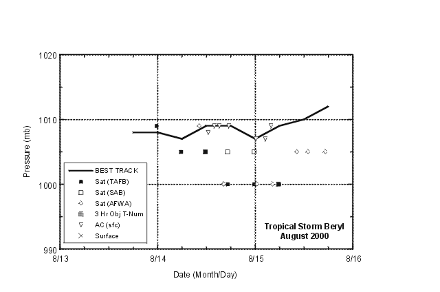
Figure 2b.
Best track minimum central pressure curve and central pressure curve
for Tropical Storm Beryl, 13-15 August 2000.
Table 2.
Watch and warning summary for Tropical Storm Beryl, 13-15 August 2000.
Date/Time
(UTC) |
Action |
Location |
| 14 / 1500 | Hurricane Warning issued | Baffin Bay, Texas south to La Pesca, Mexico |
| 14 / 1500 | Tropical Storm Warning | south of La Pesca to north of Tampico, Mexico |
| 15 / 0300 | Hurricane Warning canceled | north of Port Mansfield, Texas |
| 15 / 0300 | Hurricane Warning downgraded to a Tropical Storm Warning | Port Mansfield, Texas south to Tampico, Mexico |
| 15 / 0900 | Tropical Storm Warning canceled | all of Texas coast |
| 15 / 0900 | Tropical Storm Warning continued | Tampico, Mexico northward to U.S./Mexico border |
| 15 / 1500 | Tropical Storm Warning canceled | all of northeast coast of Mexico |
![[NCEP Logo]](graphics/ncep.gif)


