Science Features

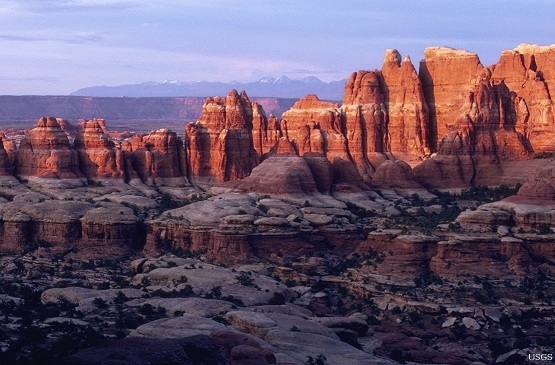
USGS scientists have worked closely with Afghan geologists, both to verify old Soviet and Afghan mineral research and to expand and enhance the total knowledge of Afghanistan's mineral wealth.
It’s not just the U.S. military working to bring a better future to Afghanistan. For Afghanistan to recover and prosper, it needs a sound understanding of its land and resources.
That’s where the USGS comes in, bringing its full range of scientific expertise to bear. From water, energy, and mineral resource assessments to geologic and climate-based hazard evaluations, the USGS has worked closely with the Government of Afghanistan to provide objective science to inform the decisions of land and resource managers in Afghanistan.
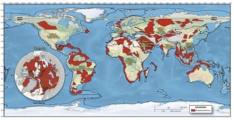
Now, after two years of exhaustive research, the USGS, Afghan Geological Survey, and the Task Force for Business and Stability Operations have released the results for 24 areas of prime mineral development in Afghanistan.
Many of these areas are world-class formations, with large deposits of critical and strategic minerals such as rare earths, gold, copper, and iron.
As the Government of Afghanistan moves forward with its plans to develop its mineral resources, the data collected by the USGS and the task force will play an important part in reducing the risk of investment for companies interested in mining these minerals.
The 24 areas studied are those with the best chance to yield high-grade mineral resources. Using geologic and airborne geospatial techniques, geochemical analysis of ground samples from each of the areas, and a cutting-edge tool called hyperspectral imaging, USGS scientists were able to create information data packets to help the Government of Afghanistan attract mineral development companies.
Mineral production and development involves considerable investment. For companies interested in developing mineral deposits, the more that is known about a deposit, the lower the risk of investment. By providing detailed analyses of these 24 areas of high mineral potential, the USGS has helped provide the Government of Afghanistan with some of the tools it needs to hold transparent, competitive bidding to develop Afghanistan’s mineral resources.
“The USGS has a long and storied history in Afghanistan,” said Marcia McNutt, Director of the USGS. “We hope our neutral and unbiased analysis of the location, supply, and flow of these strategic minerals will help the Afghans understand the true extent of their mineral wealth.”
The USGS has worked with Afghan scientists and collaborated on research projects there since the 1970s. Most recently, the USGS has partnered with other U.S. government agencies and the Afghan Geological Survey to do several resource and hazard assessments.
Working with the Afghan Geological Survey and the U.S. Agency for International Development (USAID), in 2010 the USGS released an assessment of water resource availability and needs for Kabul and surrounding areas. In the next 50 years, it is estimated that drinking water needs in the Kabul Basin of Afghanistan may increase sixfold due to population increases resulting from returning refugees. It is also likely that future water resources in the Kabul Basin will be reduced as a result of increasing air temperatures associated with global climate change.
(News Release: Kabul Basin Faces Major Water Challenges; Report: Water Resources in the Kabul Basin)
In 2009, with assistance from the Afghan Geological Survey and the U.S. Trade and Development Agency, the USGS released the first-ever assessment of undiscovered oil and gas resources, estimating a mean of 1.596 billion barrels of oil and a mean of 36.462 trillion cubic feet of natural gas. Much of the petroleum resource potential of Afghanistan and all of the known crude oil and natural gas reserves are in northern Afghanistan.
(News Release: USGS Assessment Significantly Increases Afghanistan Petroleum Resource Base; Assessment: Undiscovered Petroleum Resources of Northern Afghanistan.)
To aid in Afghanistan’s reconstruction efforts, USAID and the Afghan Geological Survey asked the USGS to help create a seismic hazard map for Afghanistan. In 2007, the map, along with an assessment of total seismic hazards, was released. The map showed that Afghanistan is located in a geologically active part of the world and without planning for the potential devastation that earthquakes can wreak years of investment in restoring Afghanistan infrastructure could be undermined in a matter of seconds.
(News Release: How Earthquakes Pose Risks to Afghanistan; Report: Earthquakes Pose a Serious Hazard in Afghanistan)
This latest mineral research is not the first time the USGS has done mineral work for Afghanistan. Back in 2007, at the request of the Afghan Geological Survey and Task Force for Business and Stability Operations, the USGS analyzed old, unpublished Soviet-era data and historical information collected by the Afghan Geological Survey and did some initial ground research to verify existing mineral deposit knowledge. The USGS was able to validate much of the data and predicted significant mineral deposits throughout Afghanistan. The latest published work confirms these predictions.
(News Release: Undiscovered Resources in Afghanistan)
USGS research in Afghanistan fulfills more than simply diplomatic relations and development of Afghanistan’s infrastructure. It also gives the USGS a chance to test cutting edge techniques and tools. One of them, hyperspectral imaging, was used to a greater extent than ever before, with USGS scientists covering an unprecedented 96 percent of the country with the tool, a higher percentage than any other country in the world.
(Science Pick: What does hyperspectral imaging mean for the future of mineral research?)
“The potential that these findings have for the future wellbeing of the Afghan people is significant,” said Ambassador Marc Grossman, U.S. Special Representative for Afghanistan and Pakistan. “The United States will continue to support the Government of Afghanistan’s efforts to develop these resources through private-sector investment in a responsible, transparent, and sustainable manner that benefits the Afghan people, expands markets, and promotes regional prosperity.”

While Curiosity investigates the Red Planet, USGS expertise will help protect the rover from hazards and analyze the data it transmits to Earth. Read more

These 3 young scientists have forged ahead with innovative research at the frontiers of science. Learn more
Maximizing alternative energy’s potential – how science can help grow the nation’s energy portfolio. Read more

Please comment on the USGS’ draft science strategies! Read more

Minerals are elementary to your everyday life, come find out how! Read more
The USGS released a new world estimate for conventional oil and gas resources.

Science or Soundbite? Is the recent increase in midcontinent earthquakes natural or man-made? Find out here.

Timing is everything! Consider helping track changes in spring’s arrival

Flood Safety Awareness Week is March. 12-16. What can you do to prepare?
National Groundwater Awareness Week is Mar. 11-17, 2012. See how USGS science is connecting groundwater and surface water.

Five USGS employees honored with Distinguished Service Awards for their service to the nation

For the first time, the USGS has estimated the potential of undiscovered, technically recoverable oil and gas resources in source rocks of the Alaska North Slope.

The proposed USGS budget reflects research priorities to respond to nationally relevant issues, including water quantity and quality, ecosystem restoration, hydraulic fracturing, natural disasters such as floods and earthquakes, and support for the National Ocean Policy, and has a large R&D component.

As the team of responders struggled to end the worst oil spill in our Nation’s history, USGS scientist Paul Hsieh provided the critical scientific information needed to make a crucial decision.

On September 11, 2001, as the twin towers of the World Trade Center exploded and collapsed, clouds of dust billowed into the sky and across the city.
Now that field work has wrapped up at the Ice Age "Snowmastodon" fossil site near Snowmass Village, Colo., USGS and other scientists will begin work on unraveling the climate and environmental history of the area.
USGS crews continue to measure streamflow and collect water quality and sediment samples in the Ohio and Mississippi River basins using state-of-art instruments.
For over 120 years, USGS has studied and mapped the National Capital region revealing a rich and diverse geologic past. Join us July 6 in Reston, Va., and learn the story of the formation and destruction of continents and oceans, the eruption of ancient volcanoes, climatic and sea level changes, as well as the hazards of modern landslides, earthquakes and karst.
Magnetic storms can cause loss of radio communication, affect global-positioning systems, damage satellite electronics and cause electrical blackouts. USGS scientists are constantly collecting geomagnetic data, and you can view new updates in near-real time.

The most recent earthquake in Japan affected water levels in groundwater wells all over the country. Water level fluctuations were recorded as far away as Illinois, Virginia, Missouri and Florida.

Soluble rock layers called “Karst” exist throughout the nation. While Karst aquifers produce half the nation’s drinking water, rock layers underneath karst dissolve easily sometimes creating sinkholes that threaten life and property. Join us May 4th to learn more about this unseen world beneath our feet.

Early maps of America, documents establishing the provenance of the Hope Diamond and documentation of explorations of the American West-- Join us in discovering the many treasures of the USGS Library.

Please answer questions about USGS Energy & Minerals science.
The need for multiple sources of energy, including the increasing demand for renewable energy, leads USGS scientists to study geothermal energy resources.
Demand for alternative energy sources leads scientists to consider microbes as potential sources of power.
Looking for information on natural resources, natural hazards, geospatial data, and more? The USGS Education site provides great resources, including lessons, data, maps, and more, to support teaching, learning, K-12 education, and university-level inquiry and research.
The USGS PAGER system (Prompt Assessment of Global Earthquakes for Response) will now include estimated economic loss and casualty information. This system is used by emergency responders, government and aid officials, and the public to understand the scope of the disaster to develop the best response.
USGS is playing a critical role in the federal government's coordinated Deepwater Horizon response efforts.
The USGS Science Strategy is a comprehensive report to critically examine the USGS's major science goals and priorities for the coming decade. The USGS is moving forward with these strategic science directions in response to the challenges that our Nation's future faces and for the stewards of our Federal lands.

7 p.m.—Public lecture (also live-streamed over the Internet)

The U.S. Geological Survey had a very busy 2011 — below are a few of our highlights from last year.

Despite news articles warning of large-scale releases of methane due to climate change, recent research indicates that most of the world’s gas hydrate deposits should remain stable for the next few thousand years.

Although no one is quite sure where the coal for naughty kids custom came from, the truth is that coal has long been a very important part of our daily lives, let alone our holiday traditions. USGS has studied coal for much of our more than 130-year existence.
USGS scientists will join thousands of scientists, managers, and decision makers in Boston this week to present new findings on toxics at the Society for Environmental Toxicology and Chemistry (SETAC) conference in the Hynes Convention Center, Nov. 13-17.

In research released September 29, 2011, USGS announced that it had mapped more than 96 percent ofAfghanistanwith hyperspectral imaging (also referred to as imaging spectroscopy data). That’s more than any other country in the world, including the U.S. Using a WB-57 aircraft as well as ground-based tools, USGS scientists directed a campaign to collect andContinue Reading

Join us on October 5th to learn more about the minerals we use on a daily basis, where these resources come from, and the steps involved from mineral discovery to mineral use.

USGS scientists are assessing the potential to remove CO2 from the atmosphere for storage in other Earth systems through a process called carbon sequestration.

![]() U.S. Department of the Interior |
U.S. Geological Survey
U.S. Department of the Interior |
U.S. Geological Survey
URL: www.usgs.gov/blogs/features/usgs_top_story/assessing-afghanistan/
Page Contact Information: Ask USGS
Page Last Modified: September 14, 2011


