Science Features
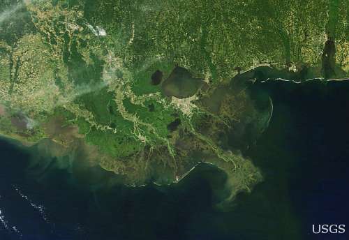
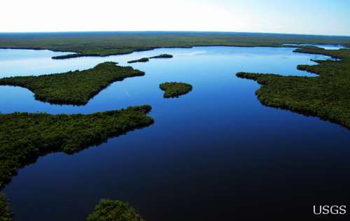
A satellite image of the Gulf of Mexico and coastline.
Every summer for the past several decades, a large dead zone has threatened the economic and ecological health of the Gulf of Mexico, the nation’s largest and most productive fishery.
This dead zone occurs because of excessive nutrients entering the rivers, lakes, and estuaries that feed into or make up the Gulf of Mexico. Nitrogen and phosphorus are essential nutrients for plant growth, but too much of them can stimulate algal growth. And as algae die, they sink to the bottom of the water and decompose, all the while robbing the water body of the oxygen needed for aquatic life to thrive.
The result? Oxygen levels can drop too low to support most life in bottom and near bottom waters, creating a hypoxic or dead zone.
The size of each year’s hypoxic zone is primarily determined by the amount of nutrients flowing from the Mississippi-Atchafalaya River Basin into the northern Gulf of Mexico – particularly the nutrient flow during April and May. Agricultural inputs are the largest source of these nutrients, though inputs from atmospheric deposition, urban areas, and wastewater treatment plants also contribute.
The largest Gulf hypoxic zone on record was in 2002, when the dead zone encompassed more than 8,400 square miles. Over the past five years, however, the size of the zone has shrunk to about 6,700 square miles — an area roughly the size of the states of Connecticut and Rhode Island combined. The size of the hypoxic zone varies each year depending on stream flows and nutrient inputs from the Mississippi-Atchafalaya River, as well as the climate, weather, and circulation patterns in the Gulf of Mexico.
Each June, a team of NOAA-supported researchers develops forecast models to predict the size of the mid-summer Gulf hypoxic zone. The forecast is based on Mississippi River nutrient inputs compiled annually by the USGS to help monitor the amount of excess nutrients flowing into the Gulf and causing hypoxia in the water.
This year, USGS scientists estimate that 58,100 metric tons of nitrogen were transported down the Mississippi and Atchafalaya rivers into the Gulf of Mexico during May, which is about 56 percent below average conditions. Stream flows were nearly half that of normal conditions for this period, resulting in less nutrient transport to the Gulf.
A team of NOAA-supported scientists from the Louisiana Universities Marine Consortium, Louisiana State University and the University of Michigan is predicting that this year’s Gulf of Mexico hypoxic zone could range from approximately 1,200 square miles to as much as about 6,200 square miles. The wide range is the result of using two different forecast models.
The smaller dead zone forecast, covering an area slightly larger than the state of Rhode Island, comes from the University of Michigan researchers. Their predicted size is based solely on the current year’s spring nutrient inputs from the Mississippi River which are significantly lower than average due to drought conditions throughout much of the river watershed.
The larger dead zone forecast, the equivalent of an area the size of the state of Connecticut, is from Louisiana Universities Marine Consortium and Louisiana State University scientists. The Louisiana forecast model includes prior year’s nutrient inputs which can remain in bottom sediments and be recycled the following year. Last year’s flood, followed by this year’s low flows, increased the influence of this “carryover effect” on the second model’s prediction.
These predictions and a scientific understanding of hypoxia are important because a more severe dead zone could lead to the decline of ecologically and commercially important species.
In 2009, for example, commercial fisheries in the Gulf were worth $629 million. In addition, three million recreational fishermen took 22 million fishing trips to the Gulf and contributed more than $1 billion to the Gulf economy.
The Gulf of Mexico/Mississippi River Watershed Nutrient Task Force is striving to reduce the size of the five-year average hypoxic zone to about 1,930 square miles. The task force’s 2008 Action Plan lists several possible steps that would help reach this goal.
USGS continues to be at the forefront of research that contributes to our understanding of the factors that determine the size of the hypoxic zone in the Gulf of Mexico and other impaired waters. This research is critical to keeping the nation’s water bodies healthy because, as a 2010 interagency report documented, the incidents of hypoxia in U.S. coastal waters has increased over the last decades, with more than 300 U.S. coastal water bodies affected.
The USGS has been monitoring nutrient transport across the nation for several decades, and recently released an online, interactive decision support system that provides easy access to six newly developed regional models describing how rivers receive and transport nutrients from natural and human sources to sensitive waters, such as the Gulf of Mexico. This online tool can be used to evaluate alternative nutrient reduction scenarios and develop science-based estimates of how changes in nutrient sources affect the transport of nutrients to local streams, as well as downstream reservoirs and estuaries.

The majority of the nation is still experiencing abnormally dry conditions, even after soaking rains from Isaac. Read more

While Hurricane Isaac has passed, scientific work to understand the storm’s impact on Gulf Coast states continues. Read more

Real-time map showing the extent of flooding (black dots) and drought (red dots) in the U.S. Read more

USGS scientists, engineers, and technicians are working along the Gulf coast in response to Hurricane Isaac. Read more

The U.S. Geological Survey is keeping careful watch as Tropical Storm Isaac continues to track northwest toward the west coast of Florida and the Gulf of Mexico. Read more

Fifteen years of data illuminate complex interactions driving land change in Puerto Rico. Read more

USGS scientists look to see if water quality is improving. Read more

The majority of the nation is facing dry conditions; in most areas drought conditions are expected to persist or intensify. Read more
Kati is a USGS student employee studying water and traveling the California coast. Read more

Please comment on the USGS’ draft science strategies! Read more

Are you surprised the water bubbles look so small? Read more

USGS Details how climate change could affect water availability in 14 U.S. Basins. Read more
Travis Gibson shares insight into the life a USGS hydrologic technician for one of the USGS water science centers out west. Read more

The USGS plays an integral role in the new U.S. Water Partnership, which will bring together public and private resources to address water challenges around the world.

Timing is everything! Consider helping track changes in spring’s arrival

Meet one of the next generation of USGS physical scientists.

Flood Safety Awareness Week is March. 12-16. What can you do to prepare?
National Groundwater Awareness Week is Mar. 11-17, 2012. See how USGS science is connecting groundwater and surface water.

Since Japan’s March 11, 2011, Tohoku earthquake and subsequent tsunami, scientists at the USGS have learned much to help better prepare for a large earthquake in the United States.

Five USGS employees honored with Distinguished Service Awards for their service to the nation

Meet a member of the next generation of USGS hydrologic technicians.
Meet a member of the next generation of USGS hydrologic technicians.

It’s National Invasive Species Awareness Week. Did you know invasive species cost our country more than 100 billion dollars each year? Get to know America’s ten top invaders this week.

Groundwater in aquifers on the East Coast and in the Central U.S. has the highest risk of contamination from radium, a naturally occurring radioactive element and known carcinogen.
The proposed USGS budget reflects research priorities to respond to nationally relevant issues, including water quantity and quality, ecosystem restoration, hydraulic fracturing, natural disasters such as floods and earthquakes, and support for the National Ocean Policy, and has a large R&D component.

Four new reports examine the contaminants polycyclic aromatic hydrocarbons (PAHs) found in house dust, streams, lakes, soil, and air.
Exploding lakes in Cameroon, Africa, have killed people and livestock. Find out how USGS science is helping prevent such an event from occurring again.
A summer intern turned permanent employee discusses his career path. Most memorable moment

Oct. 9-15, 2011, is Earth Science Week, themed "Our-Ever Changing Earth," and Oct. 12, 2011, is International Day for Natural Disaster Reduction. Answers to questions posed by a changing world
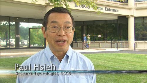
As the team of responders struggled to end the worst oil spill in our Nation’s history, USGS scientist Paul Hsieh provided the critical scientific information needed to make a crucial decision.

After years of planning, the Department of the Interior has begun removing two dams on the Elwha River in Washington. But how will the removal of these dams impact the river’s sediments, waters, and fish?

As a nation, we use more than 75 billion gallons of groundwater each day. September 13 is the National Groundwater Association’s “Protect Your Groundwater Day.” What we can do to ensure we continue to have enough of it?
USGS scientists are working to characterize the contaminants and habitats for a number of aquatic species along the lower Columbia River.
The effects of drought are felt throughout the United States and the world, and USGS science has a prominent role in understanding the causes and consequences of this hydrological phenomenon.
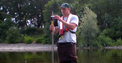
USGS crews continue to measure streamflow and collect water quality and sediment samples in the Ohio and Mississippi River basins using state-of-art instruments.
Many communities in South Dakota, North Dakota, Montana, Colorado, Wyoming and Iowa are dealing with record floodwaters and bracing for more flooding in the upcoming weeks.

The most recent earthquake in Japan affected water levels in groundwater wells all over the country. Water level fluctuations were recorded as far away as Illinois, Virginia, Missouri and Florida.

Groundwater is one of our most vital natural resources. The USGS studies the quantity and quality of the nation's groundwater. Learn about USGS research in an aquifer near you.
Learn how 3-D modeling is used to examine groundwater and how this cutting edge science is used to solve tomorrow's problems today.
The Great Lakes are the largest freshwater system on Earth. However the basin has the potential for local shortages, according to a new basin-wide water availability assessment by the USGS.
The Department of the Interior has established a new website to find and share websites that provide water conservation and sustainability information.
The USGS is providing information on arsenic levels at the town level in Maine to protect human health and further promote citizen participation in State well-testing programs.
Water Security is the protection of adequate water supplies for food, fiber, industrial, and residential needs for expanding populations, which requires maximizing water-use efficiency, developing new supplies, and protecting water reserves in event of scarcity due to natural, manmade, or technological hazards.
Decreases in stream flow, which are often caused by human activities, affect the integrity of aquatic life in streams, according to a new USGS study.
The USGS and the National Weather Service have developed a new flood inundation map tool that enables management officials and residents to see where the potential threat of flooding is the highest along the Flint River near Albany, Georgia.
Looking for information on natural resources, natural hazards, geospatial data, and more? The USGS Education site provides great resources, including lessons, data, maps, and more, to support teaching, learning, K-12 education, and university-level inquiry and research.
The Chesapeake Bay has long been an R&R destination for DC residents. However, the watershed’s overpopulation contributes to its decline. Join us when USGS’s Scott Phillips and Peter Claggett discuss new science efforts applied to restoring the Nation's largest estuary on October 6th.
The "Flood and high flow" map shows the location of streamgages where the water level is currently above or near flood stage. Find out what rivers and creeks near you are doing.
Nutrient sources in both agricultural and urban areas contribute to elevated nutrient concentrations in streams and groundwater across the Nation.
USGS is playing a critical role in the federal government's coordinated Deepwater Horizon response efforts.
Population growth in the Kabul Basin, Afghanistan, due in part to returning refugees, is estimated to lead to a six-fold increase in drinking water needs by 2057. The USGS has worked in partnership with the Afghanistan Geological Survey to address questions of future water availability.
Flash flooding is one of the major causes of natural hazard-related deaths in the United States and is hard to predict, but data collected by the USGS is crucial to formulating better predictive models.
Did you know that contaminant-ridden dust from Africa may be harming coral reefs in the Caribbean? Scientists at the USGS are examining the air in Africa and in the Caribbean to determine what kinds of nutrients, microbes, and contaminants are traveling across the ocean.
Pharmaceutical manufacturing facilities can be a significant source of pharmaceuticals in surface water. The USGS is working with water utilities to try to reduce the release of pharmaceuticals and other emerging contaminants to the environment.
The United States Group on Earth Observations (USGEO) is working to connect Earth observations with public health, agriculture, climate, and data management and dissemination.
The USGS Science Strategy is a comprehensive report to critically examine the USGS's major science goals and priorities for the coming decade. The USGS is moving forward with these strategic science directions in response to the challenges that our Nation's future faces and for the stewards of our Federal lands.

In response to Hurricane Isaac, USGS has deployed several hundred storm surge sensors to collect information about the effects of Isaac on the Gulf Coast.

7 p.m.—Public lecture (also live-streamed over the Internet)

Join us on August 1 to learn more about the anatomy of flooding: What are the different causes of these extreme events, and how is USGS science helping prepare residents for future foods.

Join us in Menlo Park for our Evening Lecture on Scanning the Seafloor with Sound!

Stressed agricultural lands may be releasing less of the moisture needed to protect the breadbasket of a continent.

The U.S. Geological Survey had a very busy 2011 — below are a few of our highlights from last year.

Over the next 10 years, the USGS plans to conduct a new assessment of water availability and use. This national Water Census will address critical aspects of recent Federal legislation, including the need to establish a national water assessment program.

Recent USGS research shows that climate, vegetation, groundwater recharge rate, and proximity of the contaminants to the water table can all affect and control natural removal rates.
USGS scientists will join thousands of scientists, managers, and decision makers in Boston this week to present new findings on toxics at the Society for Environmental Toxicology and Chemistry (SETAC) conference in the Hynes Convention Center, Nov. 13-17.

On Nov. 3, USGS scientists Patrick Barnard and William Ellsworth will present a public lecture in Menlo Park, CA, providing Bay Area residents information about USGS research in the San Francisco Bay Area, including recent discoveries beneath San Francisco Bay and ongoing studies to better understand earthquake probabilities and the potential hazards associated with strong ground shaking.

Rivers and streams in the United States are releasing substantially more carbon dioxide into the atmosphere than previously thought.

Meet the R/V Muskie and the R/V Kaho, the USGS Great Lakes Science Center's two newest additions to its Great Lakes research fleet!

![]() U.S. Department of the Interior |
U.S. Geological Survey
U.S. Department of the Interior |
U.S. Geological Survey
URL: www.usgs.gov/blogs/features/usgs_top_story/dead-zone-the-source-of-the-gulf-of-mexicos-hypoxia/?from=textlink
Page Contact Information: Ask USGS
Page Last Modified: September 14, 2011


