
Office of Planning, Environment, & Realty (HEP)
Planning

Notes on AMERICAN FACTFINDER 2: http://factfinder2.census.gov courtesy of Linda Clark, US Census Bureau and modified by Elaine Murakami, FHWA (August 18, 2011) for Summary File 1
Table P28 is Household type and Household Size (16 cells).
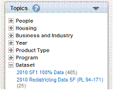
Open Topics in left navigation bar by clicking right facing arrow head.
![]()
Expand Dataset by clicking on the "+" sign. Select "2010 SF1 100% Data" by clicking on it.

Open Geographies in left navigation bar. The Geography selection pane will open in the middle of your screen.
![]()
Expand Within State by clicking on the "+" sign Then click on Texas.
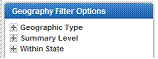
Expand Within County by clicking on the "+" sign and click on Galveston below the Geography Filter Options.
Make sure the radio button "Groups of geographies"1 is checked.
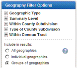
In the Geography Results pane (right box) find and check the box "All census tracts within Galveston County" and click ADD (to move this selection up into Your Selections box).

IMPORTANT! If you don't click "ADD", Tracts won't be selected.
Close Geographies by clicking on "X" in upper right of Select Geographies frame).
Then, Select P28 in the table list. Scroll to Page 6 to find P28. Then select "view" (OR, type in "P28" in the search within results box and select "go").
Once you see the table, if you prefer to see the geographic units as rows, then select Actions: "Modify Table", then select "Transpose Rows and Columns".
Another choice in the list of Actions is "Download" You can choose a comma-delimited .csv; .xls, or .pdf. Save the .zip file to your computer, and then unzip it.
Before starting Example 2, you need to clear up all "Your Selections" (upper left corner of page ) from Example 1.

The H12 table is Average Household size by Tenure.
Open Topics in left navigation bar by clicking right facing arrow head.
![]()
Expand Dataset by clicking on the "+" sign. Select "2010 SF1 100% Data" by clicking on it.
Open Geographies in left navigation bar.
![]()
The Geography selection pane will open in the middle of your screen .

Expand Within State by clicking on the "+" sign tThen click on Oregon (from the choices immediately underneath, not from the Geography Results pane).
Expand Within County by clicking on the "+" sign and Click on Multnomah.
Below the Geography Filter Options Make sure the radio button "Groups of geographies"1 is checked.

In the Geography Results pane (right box) fFind and check the box"All Blocks within Multnomah County, Oregon" and click ADD (to move this selection up into Your Selections box).

IMPORTANT! If you don't click "ADD", Blocks won't be selected. Close Geographies by clicking on "X" in upper right of Select Geographies frame.
TIP: Never close the geography overlay (or the population groups overlay or the industry code overlay) until you make sure your final choice has been moved to the "Your Selections" box. Once you close any of the overlays, your selections in the overlay are erased.
Look at the table list and put a check in checkbox next to H12 (OR, type in "H12" in the search within results box and select "go").
Then select "view" (if there are a lot of blocks, you will not be able to view it online. So instead, go to download.) In the Action list, you can select "download" the file, and select the file format you want.

1A note on the "Groups of geographies" selection. This creates "pseudo" geographies, like "All blocks within Galveston County, Texas" that are considered by AFF2 to be ONE geography.