
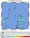
Magnitude 6.6 - MOLUCCA SEA
This webpage is being phased out and is no longer maintained. Please use the new Real-time Earthquake Map instead and update your bookmark. See Quick Tips & User Guide.
2012 August 26 15:05:37 UTC
Earthquake Details
- This event has been reviewed by a seismologist.
| Magnitude | 6.6 |
|---|---|
| Date-Time |
|
| Location | 2.197°N, 126.835°E |
| Depth | 91.9 km (57.1 miles) |
| Region | MOLUCCA SEA |
| Distances | 138 km (85 miles) WNW of Tobelo, Indonesia 168 km (104 miles) NNW of Ternate, Indonesia 169 km (105 miles) NNW of Kota Ternate, Indonesia 206 km (128 miles) ENE of Bitung, Indonesia |
| Location Uncertainty | horizontal +/- 3 km (1.9 miles); depth +/- 5.6 km (3.5 miles) |
| Parameters | NST=442, Nph=442, Dmin=168.3 km, Rmss=0.86 sec, Gp= 14°, M-type=centroid moment magnitude (Mw), Version=C |
| Source |
|
| Event ID | usc000c76x |
- Did you feel it? Report shaking and damage at your location. You can also view a map displaying accumulated data from your report and others.


Earthquake Maps


Scientific & Technical Information

 Tsunami Information
The earthquake locations and magnitudes cited in NOAA tsunami statements and bulletins are preliminary and are superseded by USGS locations and magnitudes computed using more extensive data sets.
General Tsunami Information
- Preliminary Earthquake Report
- U.S. Geological Survey, National Earthquake Information Center:
World Data Center for Seismology, Denver
