
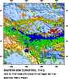
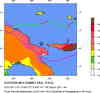
Magnitude 6.8 - EASTERN NEW GUINEA REG, PAPUA NEW GUINEA
This webpage has been replaced by a new version and will be phased out in the future. Please use our new Real-time Earthquake Map to access the latest earthquake information and event details. The links to the World, US, and CA/NV maps that were in the navigation on the left side of the page have been replaced by the links at the top of the new Map. The Real-time Earthquake Map User Guide describes how to use the map and all its features.
2012 April 17 07:13:50 UTC
Earthquake Details
- This event has been reviewed by a seismologist.
| Magnitude | 6.8 |
|---|---|
| Date-Time |
|
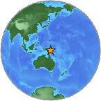
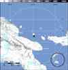
| Location | 5.474°S, 147.097°E |
| Depth | 208.2 km (129.4 miles) |
| Region | EASTERN NEW GUINEA REG, PAPUA NEW GUINEA |
| Distances | 139 km (86 miles) N of Lae, New Guinea, PNG 146 km (90 miles) ESE of Madang, New Guinea, PNG 440 km (273 miles) N of PORT MORESBY, Papua New Guinea 2516 km (1563 miles) NNW of BRISBANE, Queensland, Australia |
| Location Uncertainty | horizontal +/- 11.8 km (7.3 miles); depth +/- 5.8 km (3.6 miles) |
| Parameters | NST=584, Nph=609, Dmin=380.7 km, Rmss=0.88 sec, Gp= 11°, M-type="moment" magnitude from initial P wave (tsuboi method) (Mi/Mwp), Version=B |
| Source |
|
| Event ID | usc00095c9 |
- Did you feel it? Report shaking and damage at your location. You can also view a map displaying accumulated data from your report and others.

Earthquake Maps


Scientific & Technical Information

 Tsunami Information
The earthquake locations and magnitudes cited in NOAA tsunami statements and bulletins are preliminary and are superseded by USGS locations and magnitudes computed using more extensive data sets.
General Tsunami Information
- Preliminary Earthquake Report
- U.S. Geological Survey, National Earthquake Information Center:
World Data Center for Seismology, Denver
