Current U.S. Drought Monitor
|
The data cutoff for Drought Monitor maps is Tuesday at 7 a.m. Eastern Standard Time. The maps, which are based on analysis of the data, are released each Thursday at 8:30 a.m. Eastern Time. NOTE: To view regional drought conditions, click on map below. State maps can be accessed from regional maps. |

The U.S. Drought Monitor is produced in partnership between the National Drought Mitigation Center at the University of Nebraska-Lincoln, the United States Department of Agriculture, and the National Oceanic and Atmospheric Administration.
UPDATE: The links have been moved into the menu bars below.
NDMC's Drought Impact Reporter |
6-week animation |
12-week animation |
Custom DM animation |
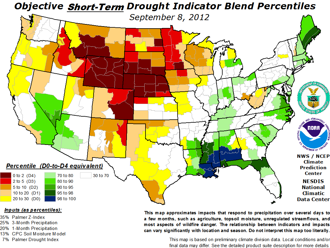
short-term drought indicator blends |
long-term drought indicator blends |
 |
 |
 |
 |
 |
 |
For local details and impacts, please contact your State Climatologist or Regional Climate Center.
| The discussion in the Looking Ahead section is simply a description of what the official national guidance from the National Weather Service (NWS) National Centers for Environmental Prediction is depicting for current areas of dryness and drought. The NWS forecast products utilized include the HPC 5-day QPF and 5-day Mean Temperature progs, the 6-10 Day Outlooks of Temperature and Precipitation Probability, and the 8-14 Day Outlooks of Temperature and Precipitation Probability, valid as of late Wednesday afternoon of the USDM release week. The NWS forecast web page used for this section is: http://www.cpc.ncep.noaa.gov/products/forecasts/. This U.S. Drought Monitor week saw some minor improvements in parts of the Mid-Atlantic, Midwest, and Northeast associated with the passage of a strong cold front during the weekend. In the Southwest, southerly flows continued to deliver monsoonal rains helping to ease drought conditions over portions of Arizona and the Great Basin. Some worsening of drought conditions continued in the Plains and Texas associated with hot, dry conditions in the region. The Northeast and parts of the Mid-Atlantic continued to benefit from recent rainfall leading to improvements in New York, Vermont, Maine, Delaware, and Maryland. The National Climatic Data Center’s “State of the Climate” report for August 2012 indicated that the contiguous U.S. experienced the third hottest summer on record. The Northeast: Widespread rains throughout the region led to improvements from Abnormally Dry (D0) to normal conditions in northeastern New York and northern Vermont while the Mohawk Valley and Finger Lakes regions improved from Moderate Drought (D1) to Abnormally Dry (D0). Long-term deficits remain in Massachusetts and Connecticut, however, and this area remained unchanged. Mid-Atlantic: Recent rains helped to improve conditions in parts of the Delmarva Peninsula which were upgraded from Severe Drought (D2) to Moderate Drought (D1). Rainfall totals ranged from two to five inches this week in Dorchester and Worcester Counties, Maryland as well as Accomack County, Virginia. The Southeast: Some locally heavy rainfall during the last week helped to improve a small area of Abnormally Dry (D0) in south-central Alabama. Otherwise, the region was generally unchanged. The South and Southern Plains: Persistence of hot and dry conditions led to expansion of Extreme Drought (D3) and Exceptional Drought (D4) in southeastern Oklahoma as well as southeastern Texas. Temperatures soared near 100 degrees, as very windy conditions exacerbated drought in the Oklahoma panhandle. Rainfall in the Texas’ Hill Country totaled no more than 50 percent of normal during the last one to two months. Northeastern Arkansas continued to receive rainfall reducing drought intensity from Extreme Drought (D3) to Severe Drought (D2). Midwest: With the passage of a strong cold front during the weekend, significant rains led to widespread one-category improvements across southeastern Missouri, Kentucky, western Tennessee, eastern Illinois, central Indiana, and southwestern Ohio. Local rains in western Kentucky ranged from 1.5 to 3.5 inches. Upward of five inches of rain fell locally this week in southeastern Missouri and western Indiana. A one-category improvement was depicted in northern Ohio, as consistent rainfall during the last two weeks provided some short-term improvement. In the northern tier, above average temperatures combined with below average precipitation during the last 30 to 45 days led to the expansion of Moderate Drought (D1) and Abnormal Dryness (D0) in Minnesota and Wisconsin. Severe drought grew to include Beltrami, Clearwater, and Mahnomen Counties in northwestern Minnesota as well. The Central and Northern Plains: The region continued to experience below normal precipitation and slightly above normal temperatures with the exception of parts of central and eastern Kansas. In the Dakotas, there was widespread expansion of Severe Drought (D2) in western North Dakota. Within the last month, the percent of normal precipitation was below 50 percent throughout most of the Northern Plains. Growing precipitation deficits in central North Dakota led to a widespread one-category degradation. A small expansion in Extreme Drought (D3) was depicted in central South Dakota as agricultural field conditions worsened. The West: In the West, Colorado and Wyoming experienced the warmest summer in 118 years while Wyoming had the driest summer on record. For August, the West experienced above average temperatures and below normal precipitation in the northwestern and northern Rockies. Overall, precipitation in August was above normal in Arizona, California, and parts of the Great Basin. During the past seven days, continued monsoonal moisture led to one-category improvements across southern Arizona, southeastern California, southwestern Colorado, southern Nevada, and southwestern Utah. Areas of Arizona, Nevada, and Utah have experienced more than 200 percent of normal precipitation during the last thirty days. A small expansion of Exceptional Drought (D4) was depicted in this week’s map as pasture and crop conditions continued to deteriorate in northeastern Colorado. Hawaii, Alaska, and Puerto Rico: These regions remained unchanged for the week. Looking Ahead: In the short-term, the HPC 5-Day forecast is predicting rainfall totals in excess of two inches throughout large portions of Texas and Oklahoma and amounts more than three inches along the Gulf Coast regions of Texas and Louisiana. Portions of drought stricken Colorado, Kansas, and Iowa are expected to receive some modest relief. The CPC 6-10 Day Outlook is projecting above average precipitation in Alaska excluding the southeastern portions. Below normal precipitation is forecasted for most of West, while above average precipitation is forecasted for the upper Great Lakes states, Northeast, and Mid-Atlantic. Temperatures around most of the West, except coastal California, will remain above average while most of the Plains and Midwest will see below average conditions. In the Northeast, above average temperatures are predicted for much of the region. |
| Dryness Categories |
| D0 ... Abnormally Dry ... used for areas showing dryness but not yet in drought, or for areas recovering from drought.
Updated September 13, 2012 |


)