Deadly Lahars from Nevado del Ruiz, Colombia
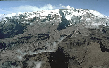
Nevado del Ruiz volcano
Located in the Andes mountains of South America, Nevado del Ruiz is the northernmost and highest Colombian volcano with historical activity. With a summit elevation of 5,389 m, the volcano is covered with 25 km2 of snow and ice even though it's located only 500 km from Earth's equator. View is from the northeast.
Beginning in November 1984, the volcano began showing clear signs of unrest, including earthquakes, increased fumarolic activity from the summit crater, and small phreatic explosions.
Explosive Eruption at Summit Crater
Broad summit of Nevado del Ruiz.
An explosive eruption from Ruiz's summit crater on November 13, 1985, at 9:08 p.m. generated an eruption column and sent a series of pyroclastic flows and surges across the volcano's broad ice-covered summit. Within minutes, pumice and ash began to fall to the northeast along with heavy rain that had started earlier in the day. The crater was enlarged slightly by the eruption, and the summit area was quickly covered with layers of pyroclastic flow deposits as thick as 8 m. This eruption was preceded by a strong phreatic (steam) explosion from the crater at 3:05 p.m. In this view, the dark pyroclastic-flow deposits are partly covered with fresh snow.
Pyroclastic Flows Melt Snow and Ice
Headwaters of Azufrado River.
Hot rock fragments of the pyroclastic flows and surges quickly eroded and mixed with Ruiz's snow and ice, melting about ten percent of the volcano's ice cover. In places, channels 100 m wide and 2-4 m deep were eroded into the icecap. Flowing mixtures of water, ice, pumice and other rock debris then poured from the summit and sides of the volcano into rivers draining the volcano. In one river, scientists found a piece of ice 2 m across about 3 km from the crater. This view of Ruiz is from the northeast.Lahars Merge at Base of Volcano
Headwaters of Gualí River.
Pumice and meltwater produced by the hot pyroclastic flows and surges swept into gullies and channels on the slopes of Ruiz as a series of small lahars. After descending several thousand meters and eroding loose rock debris from the sides of the volcano, the lahars were funneled into all six major river valleys leading from Ruiz. Here in the headwaters of the Gualí River on the north side of Ruiz, a lahar took several paths on its journey downstream.Lahars Grow in Size Through Erosion
Gualí River valley.
Flowing downstream from Ruiz at an average speed of 60 km per hour, lahars eroded soil, loose rock debris and stripped vegetation from river channels. By incorporating water and debris from along river channels, the lahars grew in size as they moved away from the volcano--some lahars increased up to 4 times their initial volumes. In some of the narrow canyons downstream from the volcano, as shown here in the Gualí River, lahars were as thick as 50 m!High Ground Means Safety
Gualí River.
Houses and towns located high enough above river channels escaped damage from the lahars. In the Gualí River valley, at least two lahar pulses were reported by eyewitnesses, separated by 5 to 15 minutes depending on distance from the volcano. Eyewitnesses reported that the noise created by the passage of each pulse made their houses and the ground shake and that conversation, even by shouting, was impossible.Towns in River Valley Destroyed
Río Lagunillas, former location of Armero.
Within four hours of the beginning of the eruption, lahars had traveled 100 km and left behind a wake of destruction: more than 23,000 people killed, about 5,000 injured, and more than 5,000 homes destroyed along the Chinchiná, Gualí, and Lagunillas rivers. Hardest hit was the town of Armero at the mouth of the Río Lagunillas canyon, which was located in the center of this photograph. Three quarters of its 28,700 inhabitants perished.Armero Destroyed
Accounts from survivors indicate Armero was inundated with several pulses of flowing material. The first arrived at 11:25 p.m. and consisted of a flood of cold relatively clean water that overflowed the Río Lagunillas channel, sweeping into downtown Armero. Only a few centimeters deep in town, this water was from a lake located just upstream that had been displaced when lahars entered the lake.
The second pulse arrived at 11:35 p.m. This was the largest pulse and within 10 to 20 minutes, destroyed most of the buildings and swept away most of the people in Armero. Flow depths of the lahar ranged from 2 to 5 m.
The third pulse arrived at 11:50 p.m. with a velocity of about half of the second one. Then, in the next hour or so, a series of smaller pulses (6 to 8) was experienced by survivors trapped in the mud. These pulses lifted people floating in the mud and pushed them a few meters ahead.
One last pulse struck Armero a short time after 1 a.m. on November 14.
Lahar generation: key lessons
For the generation of lahars on ice- and snow-covered volcanoes, the deadly 1985 eruption of Nevado del Ruiz offers several key lessons for scientists, emergency-response professionals, and communities located downstream of such volcanoes:
- catastrophic lahars can be generated on ice- and snow-capped volcanoes by relatively small eruptions
- the surface area of snow on an ice cap can be more critical than total ice volume when considereing lahar potential
- placement of hot rock debris on snow is insufficient to generate lahars -- the two materials must be mechanically mixed together for rapid heat transfer
- lahars can increase their volumes significantly by entrainment of water and eroded sediment
- valley-confined lahars can maintain relatively high velocities and can have catastrophic impacts as far as 100 km downstream


