
Magnitude 7.6 - COSTA RICA
This webpage is being phased out and is no longer maintained. Please use the new Real-time Earthquake Map instead and update your bookmark. See Quick Tips & User Guide.
2012 September 05 14:42:08 UTC
Earthquake Details
- This event has been reviewed by a seismologist.
| Magnitude | 7.6 |
|---|---|
| Date-Time |
|
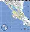
| Location | 10.086°N, 85.305°W |
| Depth | 40 km (24.9 miles) set by location program |
| Region | COSTA RICA |
| Distances | 10 km (6 miles) NE of Hojancha, Costa Rica 11 km (6 miles) ESE of Nicoya, Costa Rica 30 km (18 miles) ESE of Santa Cruz, Costa Rica 44 km (27 miles) SW of Canas, Costa Rica |
| Location Uncertainty | horizontal +/- 3.8 km (2.4 miles); depth fixed by location program |
| Parameters | NST=681, Nph=681, Dmin=44.8 km, Rmss=1.18 sec, Gp= 47°, M-type=centroid moment magnitude (Mw), Version=H |
| Source |
|
| Event ID | usc000cfsd |
- Did you feel it? Report shaking and damage at your location. You can also view a map displaying accumulated data from your report and others.
Earthquake Summary


Felt Reports
One person killed and one died of a heart attack. Some houses collapsed, one bridge damaged and landslides occurred in the epicentral area. Power and communications outages occurred. Felt strongly at San Jose and throughout much of Costa Rica. Also felt in parts of Belize, El Salvador, Guatemala, Honduras, Nicaragua and Panama.
Earthquake Maps


- Preliminary Earthquake Report
- U.S. Geological Survey, National Earthquake Information Center:
World Data Center for Seismology, Denver
