
Magnitude 8.2 - OFF THE WEST COAST OF NORTHERN SUMATRA
2012 April 11 10:43:09 UTC
Earthquake Details
- This event has been reviewed by a seismologist.
| Magnitude | 8.2 |
|---|---|
| Date-Time |
|
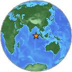
| Location | 0.773°N, 92.452°E |
| Depth | 16.4 km (10.2 miles) |
| Region | OFF THE WEST COAST OF NORTHERN SUMATRA |
| Distances | 618 km (384 miles) SSW of Banda Aceh, Sumatra, Indonesia 712 km (442 miles) W of Sibolga, Sumatra, Indonesia 1062 km (659 miles) WSW of KUALA LUMPUR, Malaysia 1773 km (1101 miles) WNW of JAKARTA, Java, Indonesia |
| Location Uncertainty | horizontal +/- 14.2 km (8.8 miles); depth +/- 6.4 km (4.0 miles) |
| Parameters | NST= 99, Nph=101, Dmin=573.3 km, Rmss=0.95 sec, Gp= 40°, M-type=regional moment magnitude (Mw), Version=7 |
| Source |
|
| Event ID | usc00090da |
- Did you feel it? Report shaking and damage at your location. You can also view a map displaying accumulated data from your report and others.
Earthquake Summary

Felt Reports
Felt (V) at Sibolga. Also felt at Banda Aceh, Bukit Tinggi, Duri, Jakarta and Padang, Indonesia. Felt (III) at Bangalore and Madras, India. Felt (V) at Ayer Itam; (IV) at Georgetown, Petaling Jaya and Sungai Ara; (III) at Butterworth, Gelugor and Kuala Lumpur, Malaysia. Felt (IV) at Colombo, Sri Lanka. Felt (II) at Phuket, Thailand. Also felt in Bangladesh, Brunei, Maldives, Singapore and Vietnam. A local tsunami was generated that resulted in wave heights of 0.2 meters at Pulau Enggano.
Tectonic Summary
The April 11, 2012, M8.6 and M8.2 earthquakes off the west coast of northern Sumatra, Indonesia, occurred as a result of strike-slip faulting within the oceanic lithosphere of the Indo-Australia plate. The quakes were located respectively 100 km and 200 km to the southwest of the major subduction zone that defines the plate boundary between the India/Australia and Sunda plates offshore Sumatra. At this location, the India/Australia plates move north-northeast with respect to the Sunda plate at a velocity of approximately 52 mm/yr.
Large strike-slip earthquakes are not unprecedented in the diffuse boundary region separating the India and Australia plates, southwest of the Sumatra subduction zone. Since the massive M 9.1 earthquake that ruptured a 1300 km long segment of the Sumatran megathrust plate boundary in December of 2004, three earlier large strike-slip events had occurred within 50 km of the first large April 11, 2012 event. These earthquakes occurred on April 19 2006 (Mw6.2), October 4 2007 (Mw6.2) and January 10, 2012 (Mw7.2). The focal-mechanisms of the three earlier earthquakes and the two great earthquakes of April 11, 2012, are consistent in implying that each earthquake could have occurred as the result of left-lateral slip on a north-northeast striking fault or right-lateral slip on a west-northwest striking fault. The two different orientations of strike-slip faulting are both possible under the same tectonic stress field; perpendicular strike-slip faults that are both compatible with the same stress field are called "conjugate faults". Possibly faults of both orientation have been involved in the recent earthquake activity.
Earthquake Maps


- Preliminary Earthquake Report
- U.S. Geological Survey, National Earthquake Information Center:
World Data Center for Seismology, Denver
