
|
Lava covers Kalapana, April 1990- January 1991 |
|
|
 | med | large | |
Lava erupts from new Kupaianaha vent Lava reaches the sea and touches Kalapana Pauses disrupt tubes; lava claims Kalapana Into the heart of Kalapana |
|
Lava erupted by Kilauea Volcano between 1983 and 1990 repeatedly invaded communities along its southern coast, destroying more than 180 homes, a visitor center in Hawai`i Volcanoes National Park, highways, and treasured historical and archaeological sites. Flows entered Kalapana briefly in November 1986, then moved through the entire community in 1990. |
|
 | med | large | |
 | med | large | |
 | med | large | |
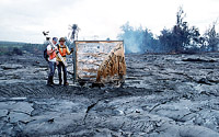
| Walter's Kalapana Store and Drive Inn (sign in photo above) was burned and covered by lava in early June as flows moved relentlessly through the Kalapana area. During this difficult period, scientists of the USGS Hawaiian Volcano Observatory provided detailed information on lava movement to the Hawai`i County Civil Defense, which made decisions regarding evacuation, road closures, and safe vantage points for residents and visitors. | ||
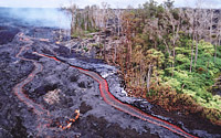
| Kalapana was covered with lava that erupted from the Kupaianaha vent (right), 3 km east of Pu`u `O`o. The eruption shifted from Pu`u `O`o to Kupaianaha in July 1986, and the style of eruption changed from intermittent episodes of high lava fountains to continuous extrusion of lava. Within weeks, a lava pond formed atop the vent and a low shield grew as lava repeatedly spilled over the rim of the pond. |  | med | large | |
|
After weeks of continuous eruption, the main lava channel leading from the Kupaianaha pond gradually roofed over to form a tube. Lava flowing through the tube system soon reached the sea in November 1986, adding new land to Hawai`i. Lava also made its way into the Kalapana area, covering roads and burning 17 homes. |
|
 | med | large | |
 | med | large | |
 | med | large | |
 | med | large | |
|
Left: Over the Thanksgiving holidays, eight residences were overrun in the community of Kapa`ahu, 3 km west of Kalapana. Lava approaches a house in Kapa`ahu as people wait to see which way the lava will move. Right: Smoke rising from burning vegetation marks the location of an active lava flow in the Kalapana area. Pu`u `O`o cone is visible on skyline. Hakuma Point and canoe landing are in the left foreground, and Walter's Kalapana Store and Drive Inn is the red-roofed building near the bay. |
|
|
In 1990, the eruption at Kupaianaha was interrupted 12 times by pauses in the supply of lava to the vent. The pauses lasted between 1 and 4 days. When each pause ended, lava was not always able to re-occupy the full length of the pre-existing tube system. During some pauses, blockages developed as the walls or roof of the main tube collapsed. When lava encountered such a blockage, it spilled onto the surface, blazed a new path downslope, and formed a new tube. |
 | med | large | |
The first pause, in early February, resulted in a new lava tube that delivered lava to Kalapana's doorstep a few weeks later. When the 4-day pause ended on February 9, the main tube was blocked only 2 km from Kupaianaha. Lava leaked onto the surface and flowed downslope along the east margin of the flow field. `A`a flows developed briefly on the steep Pulama pali and, as the channels roofed over, a new tube system developed. |
Lava nears Kalapana
 | med | large | |
By the end of February, lava moving through the new tube system entered the sea less than 2 km west of Kalapana, uncomfortably close for residents wondering whether lava would enter their community again. The 1986 flow that claimed 17 houses is visible on the right-hand side of the image (dark patch in middle). |
|
The second pause lasted 3 days. Lava entering the new tube flowed for about 8
km, then broke out of the tube and fed a new flow that spilled into the ocean
and also sent lava toward Kalapana. Within 10 days, lava entered the village for the
first time since 1986.
After the third pause on April 3-6, lava reoccupied the first 9.3 km of the main tube, then poured from the tube to feed flows that reached the heart of Kalapana 10 days later. The flows were diverted east by a 20-m-high fault block (the Hakuma horst) along the south edge of the community. This pattern was repeated during the next 7 pauses. After each pause, lava moved through the Kalapana area, eventually reaching Kaimu Bay nearly 2 km farther northeast in late August and early September. |
| Lava moved slowly through Kalapana between April and June 1990. Between Kalapana and the sea, the Hakuma horst directed the advancing flow east, right into the heart of the community (+ symbol marks the east end of the fault scarp). Hakuma Point is in the lower left. Click on an image to get a larger-sized version and additional information. | ||
 |
 |
 |
|
Lava flows first moved into Kalapana in November-December 1986 and later covered
the village in April-December 1990; maps modified from Mattox et. al. (1993)
|
||
 | med | large | |
 | med | large | |
 | med | large | |
| Slow-moving pahoehoe lava gradually spread through the community, burning homes and covering parks, roads, and gardens. This experience was extremely difficult for people who had to leave their homes and land to advancing lava. The experience was also grim for scientists monitoring the volcano and Civil Defense officials providing up-to-date information to residents. It wasn't easy to watch families abandon their community as it was slowly flooded by lava. | ||
 | med | large | |
The pahoehoe flow fronts were typically only 10-20 cm thick as they moved through the area. However, the thin leading edges of the flows quickly crusted over and stagnated. As lava continued to push beneath the crust, the cooled surface was lifted up until eventually lava again broke out of the sides and front of the inflated flows. In this way, many of the initially thin flows inflated to a thickness of more than 10 m in the Kalapana area. As the flows inflated, some road signs were pulled from the ground and raised several m above the original ground surface. |
 | med | large | |
 | med | large | |
 | med | large | |
 | med | large | |
These vertical aerial photographs record the invasion of lava into Kalapana between May and December 1990. Left: In this view, the former shoreline is shown in blue and roads in Kalapana Gardens subdivision and Highway 130 are shown in white. |
|
In late 1990, lava began leaking from the tube system near the base of Kupaianaha. Within a few months, new flows along the western edge of the flow field created a tube that was delivering lava to the sea several km west of the Kalapana area. By February 1991, the tube to Kalapana was no longer active. |
|
Kauahikaua, J., Cashman, K.V., Mattox, T.N., Heliker, C.C., Hon, K.A., Mangan, M.T., and Thornber, C.R., 1998, Observations of basaltic lava streams in tubes from Kilauea Volcano, island of Hawai`i: Journal of Geophysical Research, v. 103, no. B11, p. 27,303-27,323. Mattox, T.N., Heliker, C., Kauahikaua, Hon, K., 1993, Development of the 1990 Kalapana flow field, Kilauea Volcano, Hawaii: Bulletin of Volcanology, v. 55, p. 407-413. Heliker, C., and Wright, T.L., 1991, Lava-flow hazards from Kilauea: Geotimes, v. 36, no. 5, p. 5-19. |
|
|
