|
ADDS - METARs Help Page (2 of 5)
Back to METARs Page OR METARs help
page 3 |
Weather stations all over the world report weather
conditions every hour using a data format referred to as METAR (this is
a French acronym with a loose English translation to "routine
aviation weather observation"). These data are collected centrally
by the U.S. National Weather Service (and other country's
equivalents) and distributed. The METARs page provides a
FORM interface so that you can retrieve these data in their raw format
or you may choose to translate them to a more human-friendly
format. See the accompanying stations.txt
file for a list of airports around the world that report METARs. For
example, knowing that Denver, Colorado's airport identifier is KDEN,
you can simply retrieve the latest 24 hours worth of METARs by
entering that string into the text FORM field. You may enter as many
stations as you like and simply separate them using a space and/or
comma but you must use the full 4-letter ICAO abbreviation.
Alternatively, you may mix with state abbreviations of the form @CO
(upper and/or lower case are both valid). So, for example, you can
enter the following: KDEN KAKO KSNY KBFF @WY.
  Meteorologists in the U.S. are accustomed to
viewing the surface station data in a format like that shown here.
Unfortunately Fahrenheit is still commonly used in the U.S. for
temperature and dewpoint information. Standard practice is to plot the
mean sea level pressure (MSLP) to the upper right but with the
onslaught of fully automated weather stations, MSLP is not reported by
many stations. Instead, we choose to plot the altimeter setting in
inches of mercury while continuing the standard meteorological practice
of dropping the first digit of 2 or 3. In other words, an altimeter
setting of 30.05 is plotted as 005 while 29.83 is plotted as
983. The graphic here is self-descriptive but for aviation purposes
the cloud coverage amount is color-coded
for flight category.
Meteorologists in the U.S. are accustomed to
viewing the surface station data in a format like that shown here.
Unfortunately Fahrenheit is still commonly used in the U.S. for
temperature and dewpoint information. Standard practice is to plot the
mean sea level pressure (MSLP) to the upper right but with the
onslaught of fully automated weather stations, MSLP is not reported by
many stations. Instead, we choose to plot the altimeter setting in
inches of mercury while continuing the standard meteorological practice
of dropping the first digit of 2 or 3. In other words, an altimeter
setting of 30.05 is plotted as 005 while 29.83 is plotted as
983. The graphic here is self-descriptive but for aviation purposes
the cloud coverage amount is color-coded
for flight category.
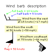
The graphic above and to the right shows how to
read wind barbs to determine the wind speed and direction. Furthermore,
the weather symbols used by meteorologists are quite cryptic (and in
bad need of modernizing by the World Meteorlogical Organization) and a
full
table of these graphics is obtained by clicking the Present Weather
label on the graphic.
|
|
This Qualified Internet
Communication Provider's (QICP) servers and communication interfaces are
approved by the FAA as secure, reliable, and accessible in accordance
with AC 00-62.
1) This QICP does not ensure the quality and
currency of the information transmitted to you.
2) The user assumes the entire risk related to
the information and its use.
|

