National Oceanic and Atmospheric Administration (NOAA)97,507 likes · 3,171 talking about this
97,507 likes · 3,171 talking about this

- AboutNOAA understands and predicts changes in the Earth's environment, from the depths of the ocean to the surface of the sun, and conserves and manages our coastal and marine resources. Visit www.noaa.gov and follow us on Twitter via @NOAA.

- Also On
- LikesSee All
- NOAA Satellite and Information ServiceGovernment Organization
- Jane LubchencoGovernment Official
- National Ocean ServiceGovernment Organization
- NOAA Fisheries ServiceGovernment Organization
- U.S. National Weather ServiceGovernment Organization
- SAVE THE DATE: SEPTEMBER 15 is INTERNATIONAL COASTAL CLEANUP 2012
Next week, people from all over the globe will come together to collect marine debris in the largest one-day volunteer event on behalf of clean oceans and waterways! Join NOA...A and "Sign Up to Clean Up" here: http://bit.ly/PZcAvr. To learn more about other ICC events, visit http://go.usa.gov/rmWm.See More
Photo: NOAA Marine Debris Program; http://www.marinedebris.noaa.gov/
- Speaking of estuaries...Take a view of your national estuarine research reserves in a whole, new way:

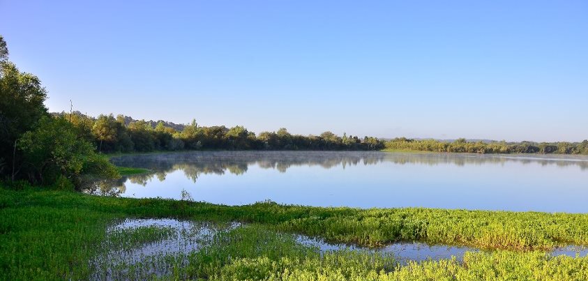
- It's Estuary Wednesday at NOAA! Here's a great photo of the Guana Tolomato Matanzas National Estuarine Research Reserve in Florida. It encompasses approximately 73,352 acres of salt marsh and mangrove tidal wetlands, oyster bars, estuarine lagoons, upland habitat and offshore seas in Northeast Florida. The GTM Reserve is located in the East Florida subregion, south of Jacksonville and sandwiching St. Augustine. It contains the northernmost extent of mangrove habitat on the East Coast of the United States, some of the highest dunes in Florida, measuring 30-40 feet, and one of the few remaining "inlets" in northeast Florida not protected by a jetty. Thus, the estuary presents an easy study of what an inlet might have looked like in the past. The coastal waters of the GTM Reserve are also important calving grounds for the endangered right whale. Learn more about NOAA's National Estuarine Research Reserves at: http://www.nerrs.noaa.gov/.
- Hey there, rock fans: Linkin Park becomes 1st band in nation to receive designation by NOAA's U.S. National Weather Service as a "StormReady Supporter" -- What does that mean exactly? See below for more:

- September 11 is a day of remembrance of lives lost and lives altered, and one of reflection for Americans in every part of our great nation. Hawaiians also remember another disaster of a different sort – a natural disaster – that devastated their state on this day 20 years ago in 1992: Hurricane Iniki. Iniki, which made landfall as a powerful Category 4 hurricane, killed six people and was to be the costliest and most powerful hurricane to strike the Hawaiian Islands. The hurricane caused close to $3 billion in damage as its eye passed directly over the island of Kauai and was one of the costliest storms in the history of the United States. Today, more than ever, we realize the importance of being prepared for any disaster that might strike -- and that means having an emergency plan for yourself and your family. Take a few moments to learn more about emergency preparedness at http://www.ready.gov/.
Image: NOAA. (September 11, 1992).
- NEW VIDEO: "Baking the Breadbasket: Persistent Drought in the Heartland"
Watch NOAA’s Deke Arndt, Chief of the Climate Monitoring Branch at the National Climatic Data Center, as he gives us a recap of Summer 2012 climate conditions across the United States -- from scorching July heat to well-below-average summer rainfall: http://1.usa.gov/RyerZE
- This. Is. So. Cool.

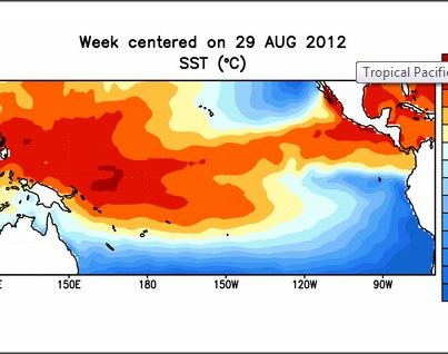
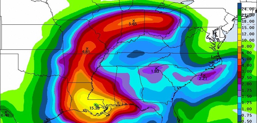
- How much did Hurricane Isaac do to relieve the U.S. drought? Not as much as you might think ... http://1.usa.gov/TCbOGV
*About the map image: A comparison of drought maps from August 28 (left) and September 4 (right) show how little relief Hurricane Isaac (track shown by blue line) brought to parched states in the central United States. A handful of states in the Lower Mississippi and Lower Ohio Valleys saw modest improvements. (Maps by NOAA Climate.gov team, based on U.S. Drought Monitor Data.)
- THIS JUST IN: According to NOAA's National Climatic Data Center, a scorching July 2012 contributed to the 3rd hottest summer on record for the contiguous United States: http://www.ncdc.noaa.gov/sotc/. Most of the United States was also drier than average. Rains from Isaac did little to relieve drought.
MORE: Get the full story about our Summer 2012 climate recap at http://www.climatewatch.noaa.gov/article/2012/summer-2012-recap
*About this image: Reds show June-August temperatures up to 8°F warmer than average. Blues show temperatures up to 2° F cooler than average — the darker the color, the larger the difference. Map by NOAA's climate.gov team and is based on U.S. Climate Division Data from NOAA's NCDC, http://www.ncdc.noaa.gov/sotc/.
- Today's turtle-themed Moment of Zen -- courtesy of NOAA Office of National Marine Sanctuaries and Papahānaumokuākea Marine National Monument

- Heads up, Twitter fans: NOAA's National Ocean Service Twitter account name is now @noaaocean.
If you were following them at @usoceangov, the switchover was automatic -- you are still following them, but you will notice their name has cha...nged. If you've never followed NOAA's National Ocean Service on Twitter, consider doing so -- they've got great articles, ocean facts, cool videos, engaging podcasts, stunning photos and more!See More - A stunning view of Hurricane Michael, the first Cat. 3 hurricane of the 2012 Atlantic hurricane season. Note: There are no coastal watches or warnings in effect, and Michael is not expected to impact the United States. See image information below, as well as more details at: http://www.nhc.noaa.gov/#MICHAEL

- Welcome back, science teachers! NOAA has new educational resources to help you and your students understand how space weather from the sun can affect us here on Earth. Check out the videos, activity suggestions, career profiles and more here: http://1.usa.gov/NuTX0a.

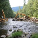
- Are you a vet looking for a job? NOAA Administrator Dr. Jane Lubchenco has posted about a NOAA/partner program in California seeking veterans to help restore critical habitat:

- This Labor Day week, NOAA Fisheries Service has good news for fish habitat and job seekers alike -- restoration projects create immediate jobs and benefit the economy in the long term. On average, restoration projects create 17 jobs per mil...lion dollars spent, which is much higher than other traditional industries including coal, gas, and nuclear energy generation. And, of course, restored fish habitat promises to increase sport and commercial fishing opportunities in the coming years. This YouTube video shows how it works: http://youtu.be/uMvM0yZbQSASee More
- For many across the country this post-Labor Day holiday, it's back to "school". Good luck on a new education year!
Photo: In the Florida Keys National Marine Sanctuary. Credit: NOAA FKNMS.
- YOUR MOMENT OF ZEN: No matter where you are or what kind of weather, NOAA wishes you a peaceful and rainbow-inspired Labor Day holiday.
Photo: Labor Day, 2005. Credit: NOAA NWS CRH.
- Learn more about this restoration project that created an oasis for wildlife out of a landfill and produced 100+ jobs: http://www.habitat.noaa.gov/highlights/landfillturnedurbanoasis.html


- NOAA's Hydrometeorological Prediction Center issued its 5-day rainfall forecast. Isaac is bringing significant rain inland - be prepared and stay informed to your local weather forecast. http://www.hpc.ncep.noaa.gov/tropical/qpf/tcqpf.php

- Satellite Captures Incredibly Detailed Image of Isaac
At 1:35pm CDT on August 28, 2012, the NOAA/NASA Suomi NPP satellite flew over Isaac, capturing this image of the storm with the true color capability of the VIIRS sensor. Image: NOAA/NASA.
Data courtesy of the NOAA/NASA Suomi NPP satellite
- ARCTIC SEA ICE BREAKS RECORD 2007 LOW: See this important news from our colleagues at NOAA Climate.gov: http://1.usa.gov/U7PsuT
[*This image shows the Arctic sea ice extent (areas with 15% or more ice cover) on August 26, 2012, based on sa...tellite data from the National Snow and Ice Data Center. The orange line shows the boundary of the previous record low sea ice extent. The dark hole in the center is an area where, historically, satellites' orbits didn't go far enough north to observe the actual pole. ]See More
- A VIRTUAL FLIGHT INTO ISAAC: Speaking of The NOAA Hurricane Hunters, take a look at this great video story shot by a television news crew from First Coast News in Jacksonville, Fla.: http://www.firstcoastnews.com/video/default.aspx?bctid=1811319594001
- Want to see what it's like to be onboard a NOAA P-3 "Hurricane Hunter" aircraft during one of its missions? NOAA Administrator Dr. Jane Lubchenco posted today about her experience during Sunday's flight (8/26) into Isaac:


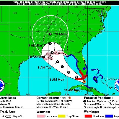
- Hurricane Isaac is still churning away... See the recent update below from NOAA NWS National Hurricane Center with important information for those in the hurricane's path:

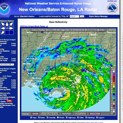
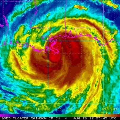
- With sunlight fading, NOAA's GOES-13 satellite captured this visible image of Hurricane Isaac last evening as the storm made landfall in Plaquemines Parish, which is about 95 miles east of New Orleans.

- The center of Hurricane Isaac made a second landfall near Port Fourchon, LA and is beginning to move inland over southeast Louisiana. Dangerous storm surge is a significant concern. Stay informed, stay alert & follow instructions from your local emergency management officials. Get the latest updates on http://www.nhc.noaa.gov/#isaac and on Twitter at @NHC_Atlantic and @usNWSgov.
- HURRICANE ISAAC PRODUCING DANGEROUS STORM SURGE: If you're within range of Isaac, remember: Stay informed, stay alert & follow instructions from your local emergency management officials. Get the latest updates on http://www.nhc.noaa.gov/#isaac and on Twitter at @NHC_Atlantic and @usNWSgov.
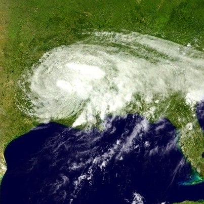
- Image of Hurricane Isaac (as a Category 1) at 7:45 EDT/6:45 p.m. CDT from NOAA's GOES-East satellite, August 28, 2012.

- HURRICANE ISAAC MAKES LANDFALL along southeast Louisiana coastline as of 6:45 p.m. CDT, according to the 8 pm EDT/7 pm CDT update from the NOAA NWS National Hurricane Center. **If you live in the affected region, be safe: Pay attention to instructions from your local emergency management officials. Keep informed on Isaac at http://www.nhc.noaa.gov/#ISAAC and on Twitter at @NHC_Atlantic.
- ISAAC UPDATE: The NOAA NWS National Hurricane Center 5:00 pm EDT advisory says Hurricane Isaac is getting better organized as it nears southeastern Louisiana. Be prepared and stay informed: Visit http://www.nhc.noaa.gov/ and @NHC_Atlantic o...n Twitter for the latest updates and warnings.See More
*This image below is from NOAA's GOES East satellite.
*You can also view the evolution of Isaac in this high-speed imagery provided by the NOAA GOES-14 satellite: http://www.nnvl.noaa.gov/MediaDetail2.php?MediaID=1166&MediaTypeID=1
- Isaac Still Just Below Hurricane Strength As It Continues Northwestward
Tropical Storm Isaac continues to move northwestward at just below hurricane strength, about 165 miles southeast of New Orleans. Isaac should reach the coastline of so...utheastern Louisiana as early as Tuesday evening, and is expected to become a hurricane before making landfall — and slowly weaken after that. A Hurricane Warning is in effect east of Morgan City, La., to the Miss.-Ala. Border. Details...http://www.nhc.noaa.gov/#ISAACSee More
Stay tuned to NOAA Weather Radio, your local NWS forecast office and local news media for impacts affecting your area. If you're on Twitter, follow the NOAA NWS National Hurricane Center updates at @NHC_Atlantic
- NOAA's Hydrometeorological Prediction Center has issued its 5-day rainfall forecast associated with Tropical Storm Isaac. Dangerous inland flooding is a concern - stay tuned to your local forecast. http://www.hpc.ncep.noaa.gov/tropical/qpf/tcqpf.php?sname=Isaac

- NOAA’s National Hurricane Center 8:00 pm EDT advisory indicates Tropical Storm Isaac is expected to become a hurricane soon. Significant storm surge and flooding from rainfall is expected along the northern Gulf coast. Be prepared and stay informed – http://www.nhc.noaa.gov/

- NOAA's National Hurricane Center says Tropical Storm Isaac poses a significant storm surge threat to the northern Gulf coast. Learn more about storm surge at http://www.nhc.noaa.gov/surge/
- Don't forget Isaac may bring heavy rain and dangerous inland flooding to your area. Stay tuned to your local NOAA National Weather Service forecast and learn more about inland flooding at http://www.noaa.gov/features/02_monitoring/inland_flooding.html
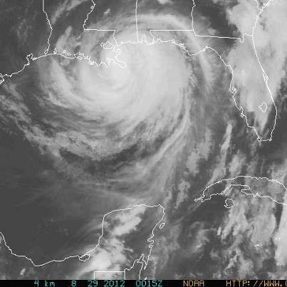
- NOAA's National Hurricane Center 5:00 p.m. advisory says the center of Tropical Storm Isaac is passing south of Key West. This image is from NOAA's GOES East satellite. Be prepared and stay informed - http://www.nhc.noaa.gov/

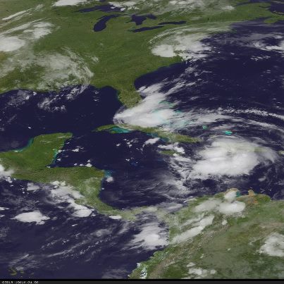
- NOAA's National Hurricane Center 11:00 a.m. advisory says Tropical Storm Isaac is lashing South Florida and the Florida Keys. Be prepared and stay informed - http://www.nhc.noaa.gov/
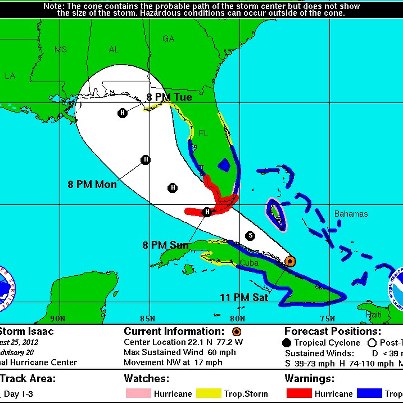
- NOAA's National Hurricane Center 11:00 p.m. advisory says Tropical Storm Isaac is heading toward the Straits of Florida and is expected to strengthen. Be prepared and stay informed - http://www.nhc.noaa.gov/
- NOAA Hurricane Hunter aircraft (4 photos)NOAA pilots, aircrew and scientists are preparing to launch a series of flights to learn more about Tropical Storm Isaac on Sunday. NOAA’s Hurricane Hunter aircraft are flying laboratories that help us unlock the mysteries of tropical cyclo...nes. Did you know that our aircraft are named after the famous Jim Henson characters Kermit, Miss Piggy and Gonzo? Kermit (one of our two WP-3D turboprop aircraft) and Gonzo (our high flying jet) will be gathering vital information about Isaac.See More