

Feature
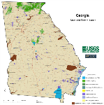
GAP Supports America’s Great Outdoors Initiative
From April through July 2011, Secretary Salazar and senior DOI officials visited governors and other high-ranking state resource staff throughout the nation to discuss President Obama's Americas Great Outdoors (AGO) Initiative. The... Learn more >>
NPScape helps National Parks understand their conservation context using PAD-US
NPScape is a landscape dynamics monitoring project that produces and delivers to US National Parks a suite of landscape-scale datasets, maps, reports, and other products to inform natural resource management and planning... Learn more >>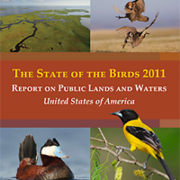
GAP data contribute to 2011 State of the Birds report
Managers use GAP data to determine how well plants and animals are being protected across the country by using three datasets: land cover, species distributions, and protected areas. ... Learn more >>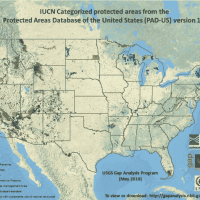
Department of Interior Strategic Plan
GAP's Protected Areas Database was featured in the Department of Interior's Strategic Plan for 2011-2016. GAP maps and data play a role in helping the Department of Interior meet its 4th mission... Learn more >>
Effects of Climate Change on the Distribution of Pika (Ochotona princeps) in the Western United States
In this analysis, two vegetation type layers, GAP and LANDFIRE, were analyzed to match the occurrence of Pika (Ochotona princeps) with vegetation types. A final suitable habitat map was produced for each... Learn more >>Get GAP Data
Review GAP data through our interactive mapping system and download land cover, species, or protected areas data sets for any area you choose. More >>
