Featured Topic
 Free Land Cover Map of North America Free Land Cover Map of North America
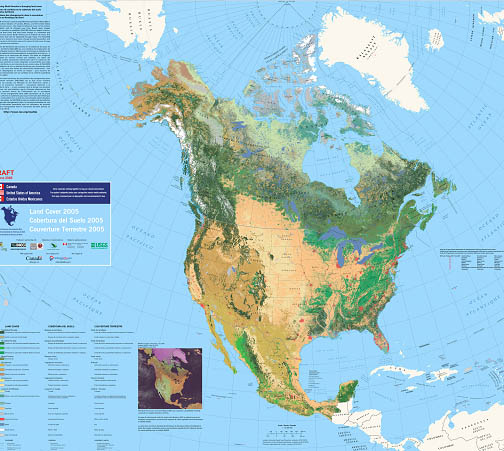
Pre-order up to five free copies of a new map showing North American Land Cover. The printed wall map (42" x 36") shows 19 land cover (vegetation) categories based on 2005 satellite data. There are no shipping or handling charges. The USGS was a primary contributor to this map.
Go here to learn how the USGS studies land cover.
Featured Topics Archive
|
USGS Educational Resources For Primary Grades Grades K-6
USGS Educational Resources For Secondary Grades Grades 7-12
USGS Educational Resources For Undergraduate Education Community Colleges and Universities
USGS Resources For California's Education Standards (K-12)
This Web site links selected online resources to an established list of Science and History-Social Science content standards for California.
Schoolyard Geology
Activities and examples of ways to turn a "field trip" through your own schoolyard into a rich geologic experience.
Handout about USGS Education Resources
Incorporate USGS science in lesson-planning with help from this convenient handout.
USGS Teacher Packets
Originally created as printed products, each teacher packet contains a teacher guide, materials, and activities covering volcanoes, maps, geologic age, fossils, caves, or ecosystems. Suitable for K-12, as indicated.
The "GPS Class"
Lessons and information about using Global Positioning Systems (GPS) in education.
USGS Publications
Search database of over 69,000 USGS maps, books, and other publications.
USGS Store
Use the USGS Store to browse and purchase paper maps and other products that are popular with educators. Just enter the Store and click on "Education Products" (teacher discounts are available). Also download free digital topographic maps by clicking on "Map Locator".
USGS Photo and Image Collections
To view a comprehensive list of USGS photos and images for public use, try theUSGS Multimedia Gallery and a list of links to our other collections.
Ask USGS
Can't find the information you need? Send your question to Ask USGS or call 1-888-ASK-USGS (1-888-275-8747). For questions related to geology only, receive a personal response from a USGS scientist by contacting Ask-A-Geologist.
|
 USGS Podcast Series USGS Podcast Series
USGS CoreCast audio files (4-15 minutes long) address topics ranging from natural hazards to human health and wildlife disease. Short on time but big on science? Listen to very brief audio files at USGS CoreFacts.
Educational Videos and Animations
A collection of USGS videos and animations covering a wide range of science.
Videotaped Lectures
A compilation of USGS videotaped lectures.
Find A Map!
Links to popular USGS map resources and map databases, including the: The National Map, and The National Atlas.
Our Changing Planet
Think that geography is just memorizing state capitals? With these USGS resources and lessons, you'll be investigating our changing planet!
Careers in Science
Web resources and videos about USGS Science and Careers.
Internships, Employment Opportunities, and Research Grants
See what opportunities are available for undergraduate and graduate students, and faculty to participate in USGS science.
NAGT-USGS Cooperative Field Training Program
Thirty-seven student interns have been placed in the 2009 National Association of Geoscience Teachers (NAGT)-USGS Cooperative Summer Field Training Program. Take a look at the exciting projects in which these students will be participating.
|
|
Predict an Eruption!
This highly interactive site uses animations, illustrations, activities, and quizzes to show how eruptions at Mount St. Helens were accurately predicted by USGS scientists, then allows students to predict an actual eruption using real data.
New Madrid Seismic Zone
A new USGS fact sheet summarizes recent developments related to seismic activity in the central Mississippi River Valley. Learn more at the USGS Web site for the New Madrid Seismic Zone.
Newly declassified images of Arctic seas
Images derived from classified materials are now available to the public through the USGS Global Fiducials Library to support environmental analysis of global climate-related science. The collection features more than 700 Arctic images that document changes in the extent of Arctic seas.
New Microbiology Web site
A new USGS Interdisciplinary Microbiology Web site is your gateway to information about the role of microbes in fish and wildlife disease, human health, bioremediation, energy resources, ecosystem function, climate change, and water quality. Includes an image gallery of bacteria and microbes.
Mineral Resource of the Month
How is a specific mineral used in the United States? How much of that mineral is produced? These questions are answered in a series of 2-page articles written for over sixty different minerals.
|

