|
|
|
Metadata
|
|
ID
|
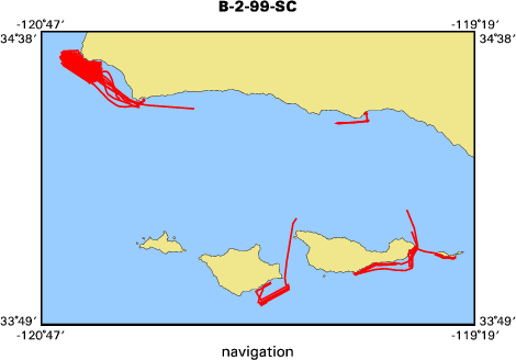
B-2-99-SC
|
|
Abstract
|
United States Geological Survey, Menlo Park, California.
Chief Scientist: Guy Cochrane. Geophysical data
(Kleinsidescan, 4khz) of field activity B-2-99-SC in Off
Vandenberg AFB, California from 10/13/1999 to 10/29/1999
|
|
Organization
|
United States Geological Survey, Menlo Park, California
|
|
Chief Scientist
|
Guy Cochrane
|
|
Activity Type
|
Geophysical
|
|
Platform
|
Ballena
|
|
Area of Operation
|
Off Vandenberg AFB, California
|
|
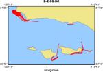
Location map
|
|
|
Bounding Coordinates
|
34.58195
-120.71859 -119.38498
33.86790
|
|
Dates
|
10/13/1999 (JD 286) to 10/29/1999 (JD 302)
|
|
Analog Materials
|
list
|
|
Index map
|
|
|
Crew
|
|
Guy Cochrane
|
Chief Scientist, USGS Western Region
|
|
Fred Payne
|
Electrical Technician, USGS Western Region
|
|
Larry Kooker
|
Electrical Technician, USGS Western Region
|
|
Marcus Lebek
|
Captain, Contractee
|
|
Adam Petusky
|
Mate, NOAA
|
|
Sarah Fangman
|
Science Coordinator, NOAA
|
|
|
Equipment Used
|
|
|
Notes
|
|
Associated cruises in southern California:
|
|
|
B-1-98-SC
|
|
B-1-99-SC
|
|
B-2-99-SC
|
|
M-1-99-SC
|
|
M-1-00-SC
|
|
J-1-02-SC
|
|
M-1-02-SC
|
|
M-1-03-SC
|
|
S-5-04-SC
|
|
|
The October Ballena cruise objective was to sidescan the NMFS study area
|
|
which encompasses the proposed Calif. State fish reserve off Vandenberg
|
|
AFB. Guy Cochrane and Fred Payne (Elec. Tech.) were the USGS crew. The
|
|
NOAA crew consisted of Marcus Lebek (Capt.), Adam Petusky, and Sarah
|
|
Fangman. The Ballena was mobilized with the Klein 2000 system on Oct. 13.
|
|
Data was collected off Pt. Arguello from Oct. 16-18. and Oct. 20-21. Use
|
|
of the Vandenberg AFB pier for a night anchorage was not possible because
|
|
the sand has filled in the embayment; we anchored off Government Point. We
|
|
were able to acquire about 200 trackline km of data which will produce
|
|
about 70 square km of coverage, 60% of the data required to map benthic
|
|
habitat in the NMFS study area. There was evidence of recent oil seepage
|
|
on the sea surface in an area where pock marks were observed on the
|
|
seafloor. We were driven out of the area by high swells and had to spend
|
|
the remainder of the cruise filling in data gaps in the areas southeast of
|
|
Santa Cruz and Santa Rosa Islands, and southwest of Anacapa Island. The
|
|
data were collected with 275 m line spacing and 200 m range. The 4KHz
|
|
subbottom profiler was used throughout. The R/V Ballena was demobilized
|
|
Oct. 29. Our next mapping cruise will be off the R/V MacArthur in May/June
|
|
in conjunction with year two Sustainable Seas operations.
|
|
|
Publications
|
|
Cochrane, G.R., Nasby, N.M., Reid, J.A., Waltenberger, B., and Lee, K.M., 2003, Nearshore
|
|
Benthic Habitat GIS for the Channel Islands National Marine Sanctuary and Southern California State
|
Fisheries Reserves Volume 1, U.S. Geological Survey Open File Report 2003-85:
|
|
http://pubs.er.usgs.gov/usgspubs/ofr/ofr0385
|
|
|
Got Help?
|
For B-2-99-SC, we would appreciate any information on -- contract, days at sea, dive count, funding, information specialist, information to be derived, kms of navigation, national plan, NGDC Info, owner, ports, project, project number, purpose, scanned materials, seismic description, station count, station description, submersible, summary, tabulated info.
|
|


