|
|
|
Metadata
|
|
ID
|
K-2-73-SC
|
|
Also Known As
|
KEL273SC
|
|
Abstract
|
Chief Scientist: Holly Wagner. Geological and Geophysical
data (uniboom, gravity, magnetics, bathymetry, airgunarcer,
samples) of field activity K-2-73-SC in Southern California
from 05/03/1973 to 05/21/1973
|
|
Chief Scientist
|
Holly Wagner
|
|
Activity Type
|
Geological and Geophysical
|
|
Platform
|
Kelez
|
|
Area of Operation
|
Southern California
|
|
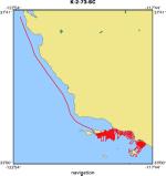
Location map
|
|
|
Bounding Coordinates
|
37.47332
-122.64660 -117.98660
33.22380
|
|
Ports
|
leave Pt. Hueneme, CA
arrive Pt. Hueneme, CA
|
|
Dates
|
05/03/1973 (JD 123) to 05/21/1973 (JD 141)
|
|
Analog Materials
|
list
|
|
Index map

|
|
|
Crew
|
|
Holly Wagner
|
Chief Scientist, USGS Western Region
|
|
|
Equipment Used
|
|
uniboom
|
|
gravity
|
|
magnetics
|
|
bathymetry
|
|
airgunarcer
|
|
samples
|
|
|
NGDC Overview
|
|
! Converted to time format with year at start.
|
|
!
|
|
DATA COLLECTION OVERVIEW (use NGDC GEODAS CD to retrieve data)
|
|
|
|
MCG Data Collection ID --- K273SC
|
|
Institution Data Collection ID --- K273SC
|
|
NGDC ID --- 06210002
|
|
Funding --- (unspecified)
|
|
Project, Cruise & Leg --- KEL273SC
|
|
Study region --- +38.00000,+33.00000,-123.00000,-117.00000
|
|
Chief Scientist(s) --- Holly Wagner
|
|
Name of vessel --- Kelez (surface ship)
|
|
Date field data collection started --- 05/03/73 (unspecified)
|
|
Date field data collection ended --- 05/17/73 (unspecified)
|
|
Parameters surveyed ---
|
|
Bathymetry: (unspecified)
|
|
Magnetics: surveyed, contained in data file
|
|
Gravity: surveyed, contained in data file
|
|
High-resolution seismics: (unspecified)
|
|
Deep penetration seismics: (unspecified)
|
|
Format --- (I1,A8,F5.2,4I2,F5.3,F8.5,F9.5,I1,F6.4,F6.1,I2,i1,3F6.1,I1,F5.1,F6.0,F7.1,F6.1,F5.1,A8,4I1)
|
|
Date of data input to NGDC --- 04/09/87
|
|
Contributing institution --- USGS Branch of Pacific Marine Geology
|
|
Country --- United States
|
|
|
|
Navigation instrumentation --- (unspecified)
|
|
Position determination method --- (unspecified)
|
|
|
|
Bathymetry instrumentation --- (unspecified)
|
|
Additional forms of bathymetric data --- (unspecified)
|
|
General rate of bathymetry in file --- (unspecified)
|
|
General collection rate of bathymetry --- (unspecified)
|
|
Assumed sound velocity --- (unspecified)
|
|
Bathymetric datum code --- No correction applied (sea level)
|
|
Bathmetry interpolation scheme --- (unspecified)
|
|
|
|
Magnetics instrumentation --- (unspecified)
|
|
Additional forms of magnetics data --- (unspecified)
|
|
General rate of magnetics in file --- 1.5 minutes
|
|
General collection rate of magnetics --- (unspecified)
|
|
Magnetic sensor tow distance --- (unspecified)
|
|
Magnetic sensor depth --- (unspecified)
|
|
Two sensor horizontal separation --- (unspecified)
|
|
Residual magnetics reference field --- (unspecified)
|
|
Method of applying residual field --- (unspecified)
|
|
|
|
Gravity instrumentation --- (unspecified)
|
|
Additional forms of gravity data --- (unspecified)
|
|
General rate of gravity in file --- 1.5 minutes
|
|
General collection rate of gravity --- (unspecified)
|
|
Theoretical gravity formula --- (unspecified)
|
|
Reference system --- (unspecified)
|
|
Corrections applied --- (unspecified)
|
|
Starting land tie --- (unspecified)
|
|
Ending land tie --- (unspecified)
|
|
|
|
Seismic instrumentation --- (unspecified)
|
|
Formats of seismic data --- (unspecified)
|
|
|
Publications
|
|
Vedder, J.G., Beyer, L.A., Junger, Arne, Moore, G.W., Roberts, A.E., Taylor, J.C.,
|
|
and Wagner, H.C., 1974, Preliminary report on the geology of the continental borderland
|
|
of Southern California: U.S. Geological Survey Miscellaneous Field Studies Map, MF-0624,
|
p. 34.
|
|
|
Arnal, R.E., and Vedder, J.G., 1976, Changes in Miocene paleobathymetry of California
|
|
continental borderland north of 32 degrees: American Association of Petroleum Geologists
|
|
Bulletin, v. 60, no. 4, American Association of Petroleum Geologists-Society For Sedimentary
|
Geology annual meeting, p. 646.
|
|
|
Arnal, R.E., and Vedder, J.G., 1976, Late Miocene paleobathymetry of California
|
|
continental borderland north of 32 degrees: American Association of Petroleum
|
|
Geologists Bulletin, v. 60, no. 12, American Association of Petroleum Geologists-
|
Society For Sedimentary Geology-SEG Pacific sections meeting, p. 2174.
|
|
|
Vedder, J.G., Taylor, J.C., Arnal, R.E., and Bukry, D., 1976, Map showing location of
|
|
selected pre-Quaternary rock samples from the California continental borderland: U.S.
|
Geological Survey Miscellaneous Field Studies Map MF-737.
|
|
|
Vedder, J.G., and Howell, D.G., 1979, Geologic framework of the southern California borderland: U.S.
|
Geological Survey Professional Paper 1150, p. 146-147.
|
|
|
Vedder, J.G., Crouch, J.K., Scott, E.W., Greene, H.G., Cranmer, D., Ibrahim, M., Tudor, R.B., and
|
|
Vinning, G., 1980, A summary report of the regional geology, petroleum potential, environmental
|
|
geology, and operational considerations in the area of proposed lease sale no. 68, offshore southern
|
California: U.S. Geological Survey Open-File Report 80-198, 64 p.
|
|
|
Campbell, R.H., Wolf, S.C., Hunter, R.E., Wagner, H.C., Junger, Arne, and Vedder, J.G.,
|
|
1975, Geologic map and sections, Santa Barbara Channel region, California: U.S. Geological
|
Survey Open-File Report 75-0123, 1 sheet.
|
|
|
Vedder, J.G., 1990, Maps of California continental borderland showing compositions and ages
|
|
of bottom samples acquired between 1968 and 1979: U.S. Geological Survey Miscellaneous
|
Field Studies Map MF-2122, 3 sheets.
|
|
Wagner, Holly C., 1975, Seismic reflection profiles, R/V/ Kelez, May 1973, Leg 2, offshore southern California, Open-File Report 75-205
|
|
|
Got Help?
|
For K-2-73-SC, we would appreciate any information on -- contract, days at sea, dive count, funding, information specialist, information to be derived, kms of navigation, national plan, notes, organization, owner, project, project number, purpose, scanned materials, seismic description, station count, station description, submersible, summary, tabulated info.
|
|


