 |
|
 |
|
|
|
|
|
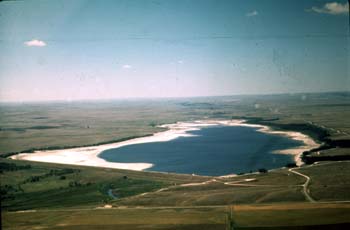
The Mirage Flats Project is in northwestern Nebraska on the Niobrara River. It includes Box Butte Dam and Reservoir, Dunlap Diversion Dam, Mirage Flats Canal, and distribution and drainage systems. Water is diverted from the Niobrara River to irrigate approximately 11,670 acres of fertile land on the north bank of the Niobrara River about 12 miles south of Hay Springs. No power is developed on the project. Water is stored in Box Butte Reservoir on the Niobrara River about 10 miles north of Hemingford. The reservoir also controls the flood flows of the river. About 8 miles downstream of Box Butte Dam, Dunlap Diversion Dam diverts water into the Mirage Flats Canal for irrigation. Water flows by gravity to project lands about 12 miles east of the diversion dam. Unit descriptions and facilities Box Butte Dam, a rock-faced zoned earthfill structure, is 87 feet high and contains 1,422,000 cubic yards of material. The spillway, located at the left abutment, is a reinforced concrete structure with a capacity of 2,700 cubic feet per second. The total capacity of the reservoir is 31,060 acre-feet. Dunlap Diversion Dam is located on the Niobrara River 8 miles downstream from Box Butte Dam. This structure has a reinforced concrete weir with a crest 80 feet long and a structural height of 12.6 feet. Mirage Flats Canal, Distribution, and Drainage System The Mirage Flats Canal extends from the diversion dam to the beginning of the irrigable land, a distance of about 13 miles, where the first large lateral, the Sturgeon, diverts water from the canal. Design capacity of the first 12 miles of the canal is 220 cubic feet per second. Major structures on the canal include five concrete siphons, a Parshall flume, spillway structures, bridges, and turnouts. There are four main laterals in the distribution system, totaling about 47 miles in length. Three drains, totaling 14 miles in length, carry floodwater and farm wastewater from the project area; the longest is 6.5 miles and has a capacity of 400 cubic feet per second. Operating agency The Mirage Flats Irrigation District operates and maintains the project. History The Dakota Indians were in possession of the area until 1877. At that time, the gold rush to the Black Hills began and the Federal Government placed the Indians on the Pine Ridge Reserve in South Dakota. Cattlemen started establishing large ranches on the open range in 1878. Operations of the early cattlemen were reduced by settlers seeking homesteads in 1883. The early homesteaders experienced a few years of good crops and immigration was greatly stimulated. By 1885, there was a homesteader on nearly every quarter section. The period of rapid settlement and good crops was followed by a severe drought, culminating in extremely dry years in 1893-94. Total failure of all crops resulted and there was a general abandonment of homesteads and decline of population. Until 1920, the Mirage Flats area was almost entirely in one ownership. About 1920, the owners began a campaign to bring settlers into the area and to divide the land into small farm units. The Farm Security Administration purchased 14,785 acres of land in the area, of which 11,200 acres were irrigable. Land development, including resubdivision of the land into farm units, land leveling, and construction of farm irrigation systems were initially done through the Farm Security Administration and later through the Soil Conservation Service. The last farm unit was sold March 1, 1950. Investigations The 1930-36 drought resulted in crop failures and a revival of interest in irrigation. The Bureau of Reclamation was requested to investigate the area to determine the feasibility of constructing an irrigation project. Detailed investigations were conducted and a report issued in 1939, which served as the basis for authorization of the project. Authorization The project was authorized by the President on April 26, 1940, under the terms of the Water Conservation and Utilization Program (act of May 10, 1939, 53 Stat. 685). Completion of the project under the act of August 11, Construction Construction of the dam and reservoir was started in January 1941, using Works Projects Administration labor. All construction was suspended by the War Production Board order of December 1942. Construction was resumed in 1944 by approval of the President and was completed in 1946. Construction of the distribution system was completed in late 1948. Irrigation Development of the project has stabilized the agricultural economy of the area, resulting in larger farm populations and increased employment in related industries. Recreation The lake created by the Box Butte Dam is ideal for aquatic and outdoor sports. The high temperatures that prevail during summer, and the cleanliness of the fresh water in the reservoir combine to make the lake an attractive spot for swimming, boating, aquaplaning, and similar water sports. Many varieties of game fish abound in the lake, such as large-mouth bass, Great Northern pike, rainbow trout, walleyed pike, and crappie. There are locations suitable for picnicking around the lakeshore. Recreation at Box Butte Reservoir, Mirage Flats Project, is managed for the Bureau of Reclamation by the Nebraska Game and Parks. Water is stored in Box Butte Reservoir, Mirage Flats Project, on the Niobrara River about 10 miles north of Hemingford, Nebraska. The reservoir lies in the arid western Niobrara River Valley in the northwestern section of the Nebraska Panhandle. The reservoir is surrounded by dense cottonwood and willow trees. It is easily one of the best birding areas in the Panhandle. Sightings since 1973 have produced a list of over 200 species. Fishing season at Box Butte Reservoir is year round. Available species include northern pike, walleye, largemouth bass, yellow perch, and channel catfish. This is an irrigation supply reservoir experiencing minor water level fluctuations. Reservoir peaks at 1,600 surface acres with 14 miles of shoreline. There are locations suitable for picnicking around the lakeshore. For specific information about Box Butte Reservoir Recreation click on the name below.
|
|
|
||
|
Dams | Projects | Powerplants | Contact Us | Maps | Glossary | FAQ´s | Links |
||