|
! Converted to time format with year at start.
|
|
!
|
|
DATA COLLECTION OVERVIEW (use NGDC GEODAS CD to retrieve data)
|
|
|
|
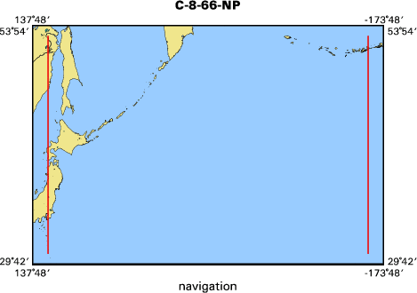
MCG Data Collection ID --- C866NP
|
|
Institution Data Collection ID --- C1008
|
|
NGDC ID --- 01010039
|
|
Funding --- (unspecified)
|
|
Project, Cruise & Leg --- CRUISE 10, LEG 8
|
|
Study region --- +53.00000,+31.00000,+139.00000,-175.00000
|
|
Chief Scientist(s) --- W. LUDWIG
|
|
Name of vessel --- ROBERT D. CONRAD (surface ship)
|
|
Date field data collection started --- 06/09/66 TOKYO, JAPAN
|
|
Date field data collection ended --- 06/28/66 ADAK, ALASKA
|
|
Parameters surveyed ---
|
|
Bathymetry: surveyed, contained in data file
|
|
Magnetics: surveyed, contained in data file
|
|
Gravity: surveyed, contained in data file
|
|
High-resolution seismics: (unspecified)
|
|
Deep penetration seismics: (unspecified)
|
|
Format --- (I1,A8,F5.2,4I2,F5.3,F8.5,F9.5,I1,F6.4,F6.1,I2,i1,3F6.1,I1,F5.1,F6.0,F7.1,F6.1,F5.1,A8,4I1)
|
|
Date of data input to NGDC --- 07/06/89
|
|
Contributing institution --- LAMONT-DOHERTY GEOLOGICAL OBSERVATORY
|
|
Country --- USA
|
|
|
|
Navigation instrumentation --- (unspecified)
|
|
Position determination method --- (unspecified)
|
|
|
|
Bathymetry instrumentation --- 06-3.5 AND 12 KHZ, WIDE BEAM (60 DEG)
|
|
Additional forms of bathymetric data --- ANALOG RECORDS
|
|
General rate of bathymetry in file --- 4.2 minutes
|
|
General collection rate of bathymetry --- ONE SECOND
|
|
Assumed sound velocity --- (unspecified)
|
|
Bathymetric datum code --- No correction applied (sea level)
|
|
Bathmetry interpolation scheme --- (unspecified)
|
|
|
|
Magnetics instrumentation --- L-DGO MFG PRORN PRECESSION
|
|
Additional forms of magnetics data --- ANALOG RECORDS
|
|
General rate of magnetics in file --- 4.2 minutes
|
|
General collection rate of magnetics --- (unspecified)
|
|
Magnetic sensor tow distance --- (unspecified)
|
|
Magnetic sensor depth --- (unspecified)
|
|
Two sensor horizontal separation --- (unspecified)
|
|
Residual magnetics reference field --- (unspecified)
|
|
Method of applying residual field --- (unspecified)
|
|
|
|
Gravity instrumentation --- ANSCHUTZ ELECTRITABLE, ASKANIA GSS2-6
|
|
Additional forms of gravity data --- ANALOG RECORDS
|
|
General rate of gravity in file --- 4.2 minutes
|
|
General collection rate of gravity --- (unspecified)
|
|
Theoretical gravity formula --- (unspecified)
|
|
Reference system --- (unspecified)
|
|
Corrections applied --- (unspecified)
|
|
Starting land tie --- (unspecified)
|
|
Ending land tie --- (unspecified)
|
|
|
|
Seismic instrumentation --- L-DGO 25CU-IN-AIRGUN,EEL, DRUM RECORDER
|
|
Formats of seismic data --- TWO, 2-CHANNEL SHEET RECORDS
|
|
|
|
Notes ---
|