
 Feeds & Data
Magnitude 6.5 - OFF THE EAST COAST OF HONSHU, JAPAN
2004 May 29 20:56:12 UTC


Earthquake Details
| Magnitude | 6.5 (Strong) |
|---|---|
| Date-Time |
= Coordinated Universal Time = local time at epicenter |
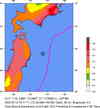
| Location | 34.256°N, 141.385°E |
| Depth | 38.1 km (23.7 miles) |
| Region | OFF THE EAST COAST OF HONSHU, JAPAN |
| Distances | 195 km (120 miles) NE of Hachijo-jima, Izu Islands, Japan 225 km (140 miles) SE of TOKYO, Japan 255 km (160 miles) SSE of Mito, Honshu, Japan 290 km (180 miles) ESE of Shizuoka, Honshu, Japan |
| Location Uncertainty | horizontal +/- 4.8 km (3.0 miles); depth +/- 7.2 km (4.5 miles) |
| Parameters | Nst=254, Nph=254, Dmin=384.7 km, Rmss=0.93 sec, Gp= 86°, M-type=teleseismic moment magnitude (Mw), Version=R |
| Source | USGS NEIC (WDCS-D) |
| Event ID | usjbbh |
- This event has been reviewed by a seismologist.
Did you feel it?
Report shaking and damage at your location. You can also view a map displaying accumulated data from your report and others.


- Preliminary Earthquake Report
- U.S. Geological Survey, National Earthquake Information Center
World Data Center for Seismology, Denver
