|
|
|
Metadata
|
|
ID
|
L-4-80-WG
|
|
Abstract
|
Chief Scientist: Monty Hampton. Geological and Geophysical
data (gravitycore, Soutargrab, airgun, uniboom, 3dot5khz,
12khz, sidescansonar, dopplersonar, integratednavigation,
RhoRho, miniranger, transitsatellite) of field activity
L-4-80-WG in Kodiak Shelf and Shelikof Straits, Western Gulf
of Alaska from 06/06/1980 to 06/20/1980
|
|
Chief Scientist
|
Monty Hampton
|
|
Activity Type
|
Geological and Geophysical
|
|
Platform
|
Samuel Phillips Lee
|
|
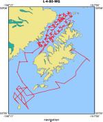
Area of Operation
|
Kodiak Shelf and Shelikof Straits, Western Gulf of Alaska
|
|
Location map
|
|
|
Bounding Coordinates
|
58.98127
-155.99190 -151.30402
55.75804
|
|
Ports
|
leave Kodiak, AK
arrive Kodiak, AK
|
|
Dates
|
06/06/1980 (JD 158) to 06/20/1980 (JD 172)
|
|
Analog Materials
|
list
|
|
Index map

|
|
|
Information Specialist
|
|
|
Crew
|
|
Aaron Dunwald
|
Chief Engineer
|
|
Bob Goodfellow
|
Watchstander
|
|
Bob Orlando
|
Geologist
|
|
Dave Hogg
|
Electronics Technician
|
|
Ernie Coleman
|
Chief Mate
|
|
Guy Cochrane
|
Watchstander
|
|
Jason Rubin
|
Watchstander
|
|
Jeff Rupert
|
Mechanical Technician
|
|
Jon Erickson
|
Mechanical Technician
|
|
Kaye Kinoshita
|
Navigator
|
|
Kris Johnson
|
Geologist
|
|
Margaret Goud
|
Navigator
|
|
Merid Dates
|
Watchstander
|
|
Mike Boyle
|
Electronics Technician
|
|
Mike Torresan
|
Geologist
|
|
Monty Hampton
|
Chief Scientist
|
|
Terry Ruff
|
Ship Captain
|
|
Tim Vogel
|
Geologist
|
|
|
Equipment Used
|
|
gravitycore
|
|
Soutargrab
|
|
airgun
|
|
uniboom
|
|
3dot5khz
|
|
12khz
|
|
sidescansonar
|
|
dopplersonar
|
|
integratednavigation
|
|
RhoRho
|
|
miniranger
|
|
transitsatellite
|
|
|
NGDC Overview
|
|
! Converted to time format with year at start.
|
|
!
|
|
DATA COLLECTION OVERVIEW (use NGDC GEODAS CD to retrieve data)
|
|
|
|
MCG Data Collection ID --- L480WG
|
|
Institution Data Collection ID --- L480WG
|
|
NGDC ID --- 06050034
|
|
Funding --- (unspecified)
|
|
Project, Cruise & Leg --- (unspecified)
|
|
Study region --- +59.00000,+55.00000,-156.00000,-151.00000
|
|
Chief Scientist(s) --- Monty Hampton
|
|
Name of vessel --- Lee (surface ship)
|
|
Date field data collection started --- 06/06/80 LV KODIAK
|
|
Date field data collection ended --- 06/20/80 AR KODIAK
|
|
Parameters surveyed ---
|
|
Bathymetry: surveyed, but not contained in data file
|
|
Magnetics: surveyed, contained in data file
|
|
Gravity: surveyed, contained in data file
|
|
High-resolution seismics: surveyed, but not contained in data file
|
|
Deep penetration seismics: not surveyed
|
|
Format --- (I1,A8,F5.2,4I2,F5.3,F8.5,F9.5,I1,F6.4,F6.1,I2,i1,3F6.1,I1,F5.1,F6.0,F7.1,F6.1,F5.1,A8,4I1)
|
|
Date of data input to NGDC --- 06/12/87
|
|
Contributing institution --- USGS Branch of Pacific Marine Geology
|
|
Country --- United States
|
|
|
|
Navigation instrumentation --- MINIRANGER,SATNAV
|
|
Position determination method --- PRIM-MINIRANGER SEC-INTEGRATED NAV
|
|
|
|
Bathymetry instrumentation --- 12KHZ NARROW 1 SEC
|
|
Additional forms of bathymetric data --- RECORDER ROLLS
|
|
General rate of bathymetry in file --- (unspecified)
|
|
General collection rate of bathymetry --- 20/SECONDS
|
|
Assumed sound velocity --- 1463.0 m/sec
|
|
Bathymetric datum code --- No correction applied (sea level)
|
|
Bathmetry interpolation scheme --- (unspecified)
|
|
|
|
Magnetics instrumentation --- (unspecified)
|
|
Additional forms of magnetics data --- (unspecified)
|
|
General rate of magnetics in file --- 1.0 minutes
|
|
General collection rate of magnetics --- (unspecified)
|
|
Magnetic sensor tow distance --- (unspecified)
|
|
Magnetic sensor depth --- (unspecified)
|
|
Two sensor horizontal separation --- (unspecified)
|
|
Residual magnetics reference field --- (unspecified)
|
|
Method of applying residual field --- (unspecified)
|
|
|
|
Gravity instrumentation --- (unspecified)
|
|
Additional forms of gravity data --- (unspecified)
|
|
General rate of gravity in file --- 1.1 minutes
|
|
General collection rate of gravity --- (unspecified)
|
|
Theoretical gravity formula --- (unspecified)
|
|
Reference system --- (unspecified)
|
|
Corrections applied --- (unspecified)
|
|
Starting land tie --- (unspecified)
|
|
Ending land tie --- (unspecified)
|
|
|
|
Seismic instrumentation --- UNIBOOM,SINGLE CHANNEL/3.5KHZ WIDE 1 SEC
|
|
Formats of seismic data --- RECORDER ROLLS
|
|
|
Publications
|
|
Hampton, M.A., Johnson, K.H., Torresan, M.E., and Winters, W.J., 1981, Description of
|
|
seafloor sediment and preliminary geo-environmental report, Shelikof Strait, Alaska: U.S.
|
Geological Survey Open-File Report 81-1133, 87 p.
|
|
|
Hampton, Monty A., and Kvenvolden, Keith A., 1981, Geology and geochemistry of gas-charged
|
sediment on Kodiak Shelf, Alaska: Geo-Marine Letters, v. 1, no. 2, p. 141-147.
|
|
|
Hampton, M.A., 1982, Synthesis report; environmental geology of Kodiak Shelf, Alaska: U.S.
|
Geological Survey Open-File Report 82-0059, 76 p.
|
|
|
Hampton, Monty A., 1982, Shelikof Strait environmental geology, in Bruns, T. R., ed.,
|
|
Hydrocarbon resource report for proposed OCS lease sale 88; southeastern Alaska, northern
|
|
Gulf of Alaska, Cook Inlet, and Shelikof Strait, Alaska: U.S. Geological Survey Open-File
|
Report 82-0928, p. 106-114.
|
|
|
Hampton, M.A., 1983, Geotechnical framework study of the Kodiak Shelf, Alaska: U.S. Geological
|
Survey Open-File Report 83-0171, 87 p.
|
|
|
Hampton, M.A., 1983, Geotechnical framework study of Shelikof Strait, Alaska: U.S.
|
Geological Survey Open-File Report 83-0200, 123 p.
|
|
|
Hampton, Monty A., 1985, Quaternary sedimentation in Shelikof Strait, Alaska:
|
Marine Geology, v. 62, no. 3-4, p. 213-253.
|
|
|
Hampton, M.A., 1983, Geology of the Kodiak Shelf, Alaska; environmental considerations
|
for resource development: Continental Shelf Research, v. 1, no. 3, p. 253-281.
|
|
|
Fisher, Michael A., von Huene, Roland, and Hampton, Monty A., 1984, Summary geologic
|
|
report for petroleum lease sale 0, Kodiak Shelf, Alaska: U.S. Geological Survey Open-File
|
Report 84-0024, 49 p.
|
|
|
Torresan, Michael E., 1984, Fabric and its relation to sedimentological and
|
|
geotechnical properties of near-surface sediment in Shelikof Strait, Alaska:
|
San Jose, CA, San Jose State University Masters Thesis.
|
|
|
Got Help?
|
For L-4-80-WG, we would appreciate any information on -- contract, days at sea, dive count, funding, information to be derived, kms of navigation, national plan, notes, organization, owner, project, project number, purpose, scanned materials, seismic description, station count, station description, submersible, summary, tabulated info.
|
|


