|
|
|
|
Metadata
|
|
ID
|
96GFP01
|
|
Also Known As
|
G-1-96-LA
96GFP01
|
|
Abstract
|
University of New Orleans,United States Geological Survey,
St. Petersburg, Florida,Lake Pontchartrain Basin
Foundation,National Oceanic and Atmospheric
Administration,Coalition to Restore Louisiana,United States
Army Corps of Engineers,Environmental Protection
Agency,University of Georgia. Chief Scientist: Jim Flocks.
Bathymetric and Vibracoring data (bathymetry, vibratingcore,
boomer, GPS) of field activity 96GFP01 (G-1-96-LA) in Lake
Pontchartrain, Louisiana (Rigotets and Chef Manter Pass, LA
and Lake Borgne, LA) from 09/13/1996 to 10/11/1996
|
|
Organization
|
University of New Orleans
United States Geological Survey, St. Petersburg, Florida
Lake Pontchartrain Basin Foundation
National Oceanic and Atmospheric Administration
Coalition to Restore Louisiana
United States Army Corps of Engineers
Environmental Protection Agency
University of Georgia
|
|
Project/Theme
|
Lake Pontchartrain Geologic Framework and Coastal Processes Study
|
|
Chief Scientist
|
Jim Flocks
|
|
Activity Type
|
Bathymetric and Vibracoring
|
|
Platform
|
Gilbert
|
|
Area of Operation
|
Lake Pontchartrain, Louisiana (Rigotets and Chef Manter Pass, LA and Lake Borgne, LA)
|
|
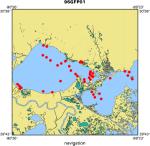
Location map
|
|
|
Bounding Coordinates
|
30.37130
-90.38875 -89.42842
29.98282
|
|
Ports
|
leave New Orleans
arrive New Orleans
|
|
Dates
|
09/13/1996 (JD 257) to 10/11/1996 (JD 285)
|
|
Analog Materials
|
list
|
|
Index map

|
|
|
Information Specialist
|
|
Kate Ciembronowicz
|
|
Chandra Dreher
|
|
Karynna Calderon
|
|
|
Crew
|
|
Jim Flocks
|
Chief Scientist, USGS St. Petersburg
|
|
Paul Conner
|
Geologist, UNO New Orleans
|
|
Kevin Geraghty
|
Boat Captain, USGS St. Petersburg
|
|
Dana Wiese
|
Electronics Technician, USGS St. Petersburg
|
|
Shea Penland
|
Geologist, University of New Orleans
|
|
Richard Young
|
Boat Captain, USGS St. Petersburg
|
|
|
Equipment Used
|
|
bathymetry
|
|
vibratingcore
|
|
boomer
|
|
GPS
|
|
|
Purpose
|
|
Lake Pontchartrain Geologic Framework and Coastal Processes study was to
|
|
analyze environmental change focusing on evaluating environmental conditions,
|
|
sediment quality, coastal processes and geomorphology.
|
|
|
Information to be Derived
|
|
Bathymetry interpretation for geologic shoreline changes. Vibracores
|
|
used to derive high-resolution sedimentation patterns post Pleistocene geologic
|
|
framework.
|
|
|
Summary
|
|
Bathymetry, boomer (24 lines), vibracore.
|
|
|
Notes
|
|
G-1-96-LA - These FACS logs were generated by Chandra Dreher in June of
|
|
2003, using the handwritten logbooks and personal accounts of the scientist and
|
|
crew members. Contains Vibracore samples with three different sample names
|
|
consisting of PON96-#, RIG96-#, LB96-#. These samples are stored at the
|
|
University of New Orleans, New Orleans, LA (for further information, contact
|
|
Phil McCarty pmccarty@uno.edu).
|
|
|
Publications
|
|
Flocks, J.G., New Field Sampling Techniques and Data Description, 1998, U.S. Geological Survey Open-File Report 98-805, available on-line at:
|
http://pubs.usgs.gov/of/of98-805/html/flocks.htm
|
|
|
Calderon, Karynna, Dadisman, Shawn V., Kindinger, Jack L., Williams, S.
|
|
Jeffress, Flocks, James G., Penland, Shea, and Wiese, Dana S., 2003, Archive
|
|
of digital boomer seismic reflection data collected during USGS cruises
|
|
94GFP01, 95GFP01, 96GFP01, 97GFP01, and 98GFP02 in lakes Pontchartrain, Borgne,
|
|
and Maurepas, Louisiana, 1994-1998: U.S. Geological Survey Open-File Report
|
03-497, CD-ROM.
|
|
http://coastal.er.usgs.gov/pontchartrain/
|
|
|
Got Help?
|
For 96GFP01, we would appreciate any information on -- contract, days at sea, dive count, funding, kms of navigation, national plan, NGDC Info, owner, project number, scanned materials, seismic description, station count, station description, submersible, tabulated info.
|
|