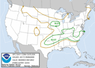
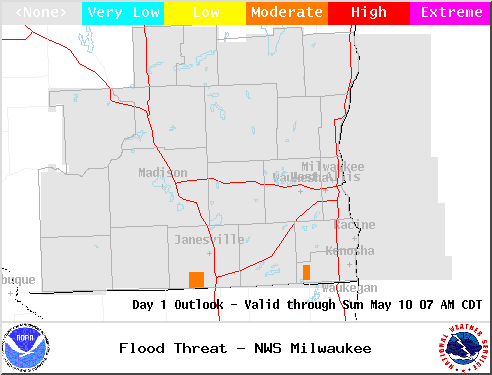
Hazardous Weather Outlook Page 000 FLUS43 KMKX 090856 HWOMKX HAZARDOUS WEATHER OUTLOOK NATIONAL WEATHER SERVICE MILWAUKEE/SULLIVAN WI 356 AM CDT SAT MAY 9 2009 WIZ046-047-051-052-056>060-062>072-100900- MARQUETTE-GREEN LAKE-FOND DU LAC-SHEBOYGAN-SAUK-COLUMBIA-DODGE- WASHINGTON-OZAUKEE-IOWA-DANE-JEFFERSON-WAUKESHA-MILWAUKEE- LAFAYETTE-GREEN-ROCK-WALWORTH-RACINE-KENOSHA- 356 AM CDT SAT MAY 9 2009 THIS HAZARDOUS WEATHER OUTLOOK IS FOR PORTIONS OF EAST CENTRAL WISCONSIN...SOUTH CENTRAL WISCONSIN AND SOUTHEAST WISCONSIN. .DAY ONE...TODAY AND TONIGHT EARLY MORNING HEAVY RAINFALL OF 1 TO 2 INCHES IN SOME LOCATIONS NORTH OF A LINE FROM MADISON TO MILWAUKEE INCLUDING THE BEAVER DAM...DEFOREST AND COLUMBUS AREAS WILL TAPER OFF QUICKLY. THE HEAVY RAINFALL WILL RESULT IN PONDING OF WATER ON ROADWAYS. A PERIOD OF STRONG NORTHWEST WINDS OF 20 TO 30 MPH WITH GUSTS TO 35 MPH IS EXPECTED THIS MORNING. .DAYS TWO THROUGH SEVEN...SUNDAY THROUGH FRIDAY PATCHY FROST IS POSSIBLE IN LOW LYING AREAS LATE SUNDAY NIGHT. THERE IS A CHANCE OF THUNDERSTORMS TUESDAY NIGHT THROUGH WEDNESDAY NIGHT. .SPOTTER INFORMATION STATEMENT... SPOTTER ACTIVATION WILL NOT BE NEEDED BUT RAINFALL REPORTS ARE APPRECIATED. $$ LMZ643>646-100900- SHEBOYGAN TO PORT WASHINGTON WI- PORT WASHINGTON TO NORTH POINT LIGHT WI- NORTH POINT LIGHT TO WIND POINT WI- WIND POINT WI TO WINTHROP HARBOR IL- 356 AM CDT SAT MAY 9 2009 THIS HAZARDOUS WEATHER OUTLOOK IS FOR PORTIONS OF LAKE MICHIGAN. .DAY ONE...TODAY AND TONIGHT A SMALL CRAFT ADVISORY IS IN EFFECT THROUGH MID AFTERNOON. WINDS WILL APPROACH GALE WARNING CRITERIA THIS MORNING. .DAYS TWO THROUGH SEVEN...SUNDAY THROUGH FRIDAY THERE IS A CHANCE OF THUNDERSTORMS TUESDAY NIGHT THROUGH WEDNESDAY NIGHT. $$ WWW.WEATHER.GOV/MKX MBK