|
Print Page | ||||||
| Folsom Field Office | |||||||
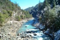
South Yuba River
General Information The South Yuba River is a combination of history, scenic beauty, and whitewater excitement. This Gold Country river flashes and dances through an intricate minefield of boulders on its downstream journey. The region once drew hordes of prospectors whose hydraulic mining activity left its mark on cliffs and hillsides. You can learn about this water-powered mining at Malakoff Diggins State Historic park only minutes from the river. Gold still sparks a fever of excitement here and weekends see the Yuba transformed into an upriver playground for swimming , fishing, and nugget panning. Another riverside attraction is BLM's South Yuba Campground, complete with miles of trails, and developed campsites nestled in thick conifer forest. When to go: Spring-early summer Getting there: Highway 49 North of Nevada City to North Bloomfield Road. Put-in: Washington Bridge, Edwards Crossing. Take-out: Edwards Crossing, Purdon Road Bridge. Portages: Twelve (12) foot waterfall below Humbug Creek; Diversion dam before Purdon Road. |
|||||||