
 Feeds & Data
Magnitude 6.2 - TAIWAN REGION
2007 September 06 17:51:26 UTC
Earthquake Details
| Magnitude | 6.2 |
|---|---|
| Date-Time |
|
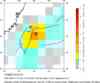
| Location | 24.313°N, 122.255°E |
| Depth | 53 km (32.9 miles) set by location program |
| Region | TAIWAN REGION |
| Distances | 50 km (30 miles) SE of Su-ao, Taiwan 80 km (50 miles) ENE of Hua-lien, Taiwan 110 km (70 miles) SE of T'AI-PEI, Taiwan 140 km (85 miles) ESE of Hsin-chu, Taiwan |
| Location Uncertainty | horizontal +/- 4.1 km (2.5 miles); depth fixed by location program |
| Parameters | NST=219, Nph=219, Dmin=69.1 km, Rmss=0.92 sec, Gp= 32°, M-type=body wave magnitude (Mb), Version=V |
| Source |
|
| Event ID | us2007gybt |
- This event has been reviewed by a seismologist.
- Did you feel it? Report shaking and damage at your location. You can also view a map displaying accumulated data from your report and others.
Earthquake Summary


The following is a release by the United States Geological Survey, National Earthquake Information Center: An earthquake occurred about 50 km (30 miles) ESE of Su-ao or about 110 km (70 miles) SE of T'AI-PEI, Taiwan at 11:51 AM MDT, Sep 6, 2007 (Sep 07 at 1:51 AM local time in Taiwan). The magnitude and location may be revised when additional data and further analysis results are available. Felt throughout Taiwan.
Felt Reports
One building damaged at Lo-tung. Felt at Hua-lien, I-lan and T'ai-tung. Recorded (5 TAP) in Hua- lien, T'ai-tung and I-lan; (4 TAP) in Chang-hua, Nan-t'ou and T'ai-chung; (3 TAP) in Chia-i, Hsin- chu, Kao-hsiung, Miao-i, T'ai-pei, T'ao-yuan and Yun-lin; (2 TAP) in Peng-hu, P'ing-tung and T'ai- nan; (1 TAP) in Lien-chiang Counties. Recorded (3 JMA) on Yonaguni-jima; (2 JMA) on Iriomote-jima and Ishigaki-jima; (1 JMA) on Miyako-jima and Tarama-shima.
Earthquake Maps


Scientific & Technical Information

- Preliminary Earthquake Report
- U.S. Geological Survey, National Earthquake Information Center:
World Data Center for Seismology, Denver
